
Report of the Inter-Departmental
Group on National Coastal Change
Management Strategy
Prepared Jointly by the Department of
Housing, Local Government and Heritage
& the Office of Public Works
gov.ie

Table of Contents
Joint Ministerial Foreword ...................................................................................................................... 1
Executive Summary ................................................................................................................................. 3
Introduction ........................................................................................................................................ 3
Structure of Scoping report ................................................................................................................ 3
Chapter One - Introduction ................................................................................................................. 4
Chapter Two - Approaches to Coastal Change in other Jurisdictions ................................................. 4
Chapter Three - Current Irish Regulatory Context .............................................................................. 6
Chapter Four - Building the evidence base ......................................................................................... 6
Chapter Five - Key elements of an Irish Coastal Change Management Strategy ............................... 7
Strategic Pillar 1 – Enhancing Governance and Capacity Building ...................................................... 7
Strategic Pillar 2 - Understanding the Risk and Identifying Potential Technical Risk Management
Options ................................................................................................................................................ 8
Strategic Pillar 3 - Developing Management Responses to Coastal Change ...................................... 8
Summary of Recommendations ............................................................................................................ 10
Strategic Pillar ................................................................................................................................... 10
Recommendation .............................................................................................................................. 10
Strategic Pillar 1 ................................................................................................................................ 10
Strategic Pillar 2 ................................................................................................................................ 11
Strategic Pillar 3 ................................................................................................................................ 13
Glossary of Terms / Acronyms .......................................................................................................... 16
1. Introduction ...................................................................................................................................... 21
2. Approaches to Coastal Change in Other Jurisdictions ...................................................................... 29
3. Current Irish Regulatory Context .................................................................................................. 35
4.0 Building the Evidence Base – Informing Strategic Coastal Management ................................. 43
5. Key elements of an Irish Coastal Change Strategy .......................................................................... 58
1
Joint Ministerial Foreword
It is clear that climate change is causing significant challenges for the entire planet. Many areas
around the world are already experiencing the impacts of climate change through more frequent
extreme weather events, changes in rainfall patterns and changes in temperature norms. Ireland is not
immune from these challenges and as temperatures are predicted to continue to rise due to the impact
of greenhouse gas emissions during this century the predictions for increases in sea levels will
exacerbate the problems that we will face, including in relation to our coastal areas.
Human activities are estimated to have already caused approximately 1.0°C of global warming above
pre-industrial levels, and global mean sea level has risen about 20 cm since the beginning of the 20th
century, and is rising at approximately 3.5 cm per decade at present. The Intergovernmental Panel on
Climate Change has reported that for a 1.5°C rise in temperature, the global mean sea level could rise
by up to approximately 1m by 2100, and projections of more intense Atlantic storms could potentially
increase surge events and wave heights. This will further and significantly change our coastline and
could adversely impact on our coastal economy, society, heritage, culture and environment, if such
change is not managed appropriately.
In response to these challenges, the Government established the IDG Coastal Change to provide a
framework for key decisions to be taken on how Ireland can best manage its coast, being aware of the
future risks and the associated planning requirements. This report puts in place a road map for
responding to these challenges in a structured and planned way to provide the basis for a long-term
strategy for an integrated and co-ordinated approach to coastal change management.
Tackling coastal change management in response to climate change will be complex, multi-faceted
and dynamic demanding a range of research, policy and consequent management responses. This
report contains a range of recommendations, structured across three strategic pillars, for the
Government to consider. They are centred on developing management responses to coastal change
over the short, medium and longer terms and providing a comprehensive whole of Government
approach to the development of the range of policy responses that the challenge of coastal change
encompasses.


3
Executive Summary
Introduction
Ireland’s coastline is a valuable natural resource, which needs careful and sensitive management.
However, Ireland’s coast faces many challenges. The Climate Action Plan 2021 (DECC, 2021) identifies
that increases in sea levels and storm surge will result in increased frequency of coastal flooding and
erosion, with significant impacts for coastal and heritage sites situated in proximity to the coast and
on estuaries. The current evidence points to a gradual sea level rise of up to 1 metre to the year 2100
due to climate change. This will further and significantly change our coastline and could adversely
impact on our coastal economy, society, heritage, culture and environment, if such change is not
managed appropriately.
The Government has adopted a policy to assess and manage coastal flood risk with regard to both
existing risk and the potential impacts of climate change. However, managing Ireland’s coastal flood
risk addresses only part of the wider coastal change issues, and is not a strategy to manage all of
Ireland’s coastal hazards, nor does it provide a baseline assessment of the other hazards, including
from coastal erosion. This position is complicated by the fact that multiple investment projects along
the coast are typically planned and led by individual sectors and decisions are taken within Local
Authority (LA) boundaries.
Based on international best practice, ensuring best outcomes for the coastal area would be better
informed by an integrated coastal change management strategy. This would provide a framework to
determine the key decisions to be taken on how Ireland could best manage its coast, being aware of
the future risks and the associated planning requirements. An integrated coastal change management
strategy approach would also provide the framework to best inform both where and how decisions
regarding appropriate development/projects along the coast should be taken in the future, in
coordination with investment in flood risk management. The projected impact from climate change
reinforces the need to adopt such a strategic approach, with much more urgent attention required
with regards to coastal resilience (Climate Change Advisory Council, 2022).
In this context, an inter-departmental group was established by the Government to consider the
scoping of a National Coastal Change Management Strategy having regard to these issues. In so
doing it is recognised that there are current and urgent coastal change issues to be addressed in
parallel to the implementation of a medium to long-term framework. This group was tasked with
initially scoping out an approach for the development of an integrated, whole of Government,
strategy for managing our changing coast and to report back to Government with initial findings and
recommendations.
Structure of Scoping report
This scoping report is divided into five interrelated chapters:
Key elements
of an Irish
Coastal Change
Management
Strategy
Building the
evidence base
Current Irish
Regulatory
Context
Approaches to
Coastal Change
in other
Jurisdictions
Introduction
4
A summary of these chapters follows:-
Chapter One - Introduction
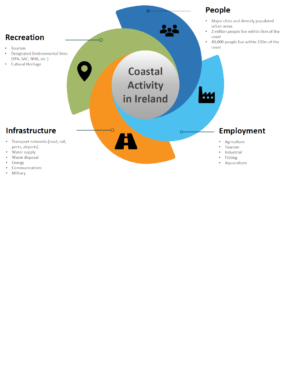
About 40% of people in Ireland live within 5km of the coast and about 40,000 live within 100 metres
of the coast (CSO, 2017). Ireland’s coastline is relatively long compared to other European countries
spanning approximately 5,800km.
Ireland’s coastal zone is characterised by considerable diversity, both in natural terms and in the range
and extent of human activity, including:
urban, rural and island coastal communities,
all of our major cities and the most densely populated parts of the country,
much of the country's industry is concentrated on or near the coast,
infrastructural and utility services including transport networks of road, rail, ports and
harbours; water supply and waste disposal; power, energy and communications; and
military infrastructures,
important economic resources for many sectors, e.g. the agricultural and tourism
sectors,
many areas of conservation value, due in part to the high ratio of coast to land area,
including designated areas of special conservation, geology and structures and sites
of cultural heritage significance,
access to a vast marine resource including fisheries, aquaculture and energy.
Coastal change management in the context of this report relates to the management of hazards and
risks at the coast associated with coastal erosion, accretion and the displacement of the inter-tidal
zone due to sea level rise, and in particular the potential increase in these hazards and risks
associated with the impacts of climate change. Existing arrangements are already in place with
regards to the risks of coastal flooding, and so this is not within the remit of the group or this
report.
Currently, there is no ongoing monitoring of Ireland’s changing coast that encompasses all of the
various risks. However, a range of work, already undertaken or ongoing, provides a certain level of
information and some indicators of the extent of the issue.
Tackling coastal change management in response to climate change will be complex, multi-faceted
and dynamic, demanding a range of policy and consequent operational responses.
A key objective of this report is to put in place a road map for responding to these challenges in a
structured and planned way to provide the basis for a long-term strategy for integrated coastal
change management.
Chapter Two - Approaches to Coastal Change in other Jurisdictions
An important task in preparing this report, was to consider lessons which could be learned from
other jurisdictions based on a range of EU and UK research projects. In addition, a desktop survey
was carried out to elicit policy development in a number of relevant European Countries with
geographic similarities, i.e. those European countries bordering the Atlantic seaboard and the North
Sea.
Since 1996, the European Commission has been working to identify and promote measures to
remedy the deterioration of Europe's coastal zones and to improve the overall situation. For over
two decades, the EU approach has promoted Integrated Coastal Zone Management (ICZM), at the
heart of which is coastal erosion management.

5
ICZM seeks to balance the various economic and social claims to the use of coastal areas (fishing,
shipping, port operation, industry and commerce, land-based transport infrastructure, agriculture
and forestry, wind energy, settlement development, tourism, etc.) with the objectives of coastal
zone protection (avoiding pollution, efficient use of the resource land, nature and cultural heritage
conservation, flood protection, etc.).
Similarly to Ireland, and influenced by broader EU developments in some cases, many countries are
developing marine spatial plans at national and regional level, with a varying degree of references to
coastal erosion and coastal change. There is a degree of evolution in these policies, and while there
are examples of good practice, there are other areas where the specific implementation issues are
less clear or well defined.
It is clear from the review of international practice, that while there are certain common themes,
often driven by EU Directives, there are varying models of coastal change management in other
jurisdictions reflective of their experience, legal and institutional culture.
There are a number of reasons why this is the case, such as the differing risks posed by coastal
change in each jurisdiction and the differing roles and responsibilities of various government
departments, agencies and local government bodies, etc. Consequently, there is no obvious single
model of best practice apparent for direct application in Ireland.
Drawing from the many examples of good practice in the management of coastal change evident in
the approach of other jurisdictions, there are a number of broad themes which should be considered
in any future policy being developed for Ireland, including:
Policy approach
o The need for coastal change management plans to be prepared to identify the
appropriate measures necessary to best manage the risks associated with
coastal change, in the short, medium and longer terms, with such plans
reviewed and updated at appropriate intervals.
o The consideration and application of high level risk management policy options
along the coastline or parts thereof. For example, no active intervention, hold
the line, managed realignment, managed retreat or advance the line, along each
reach of the coastline, as used in the UK Shoreline Management Plans.
o The use of a sediment management approach which can include various scales
of assessment based on sediment cells and sub-cells.
o The emphasis on sustainable management of the coastline as evident in the
approach in the UK, the Netherlands and Denmark.
Communications
o The importance of clearly communicating risks associated with coastal change to
coastal communities and including these communities in the decision making
process.
Data and Research
o The availability of high quality data to inform the decision making process. For
example, regular monitoring of coastal retreat and dunes (annually), monitoring
of dyke consolidation and monitoring of water levels and wave conditions as is
carried out in Denmark. Similarly, the National Network of Regional Coastal
Monitoring Programmes of England collect coastal monitoring data in a co-
ordinated and systematic manner to serve their coastal management needs.

6
o The importance of research to provide the up-to-date information required to
manage the risk from coastal change. In the UK, the Environment Agency
manages a Flood and Coastal Erosion Risk Management Research and
Development Programme which is a collaborative and academic led research
programme to provide information on the management of flood and coastal
erosion risk.
Chapter Three - Current Irish Regulatory Context
At the heart of the challenge of integrated coastal management is the issue of timescale. Regardless
of reduction in greenhouse gas emissions, sea levels will continue to rise for a significant length of
time, certainly much longer than ‘normal’ planning horizons.
While recognising that this is happening, there is a need to put in place responses that recognise the
long-term nature of the challenge. A key objective of this report is to put in place a road map for
responding to these challenges in a structured and planned way to provide the basis for a long-term
strategy for integrated coastal change management. Particularly important in this context is that
Ireland now has national planning frameworks in place for both the terrestrial area and the marine
area.
The legislative framework in the coastal zone is very complex and intricate, involving both EU and
national measures. In summary, the legislative measures serve one of three principal purposes - the
approval for future development, administration of activities or protection of the environment.
The regulatory framework relating to environmental considerations is complex and is heavily
informed by EU Directives. The embedding of environmental considerations into the regulatory
process is ongoing and is reflective of emerging case law and experience.
Measures to avoid further damage to the environment and where possible make improvements to it
will continue to be a feature of the regulatory environment. For the future, consideration needs to
be given to how best to integrate necessary responses to coastal change into an environmental
regulatory framework.
Chapter Four - Building the evidence base
Data and research are a critical underpinning to future policy evolution and implementation.
A Technical Working Group (TWG) was established to identify the current datasets and research
available across State organisations relevant to the monitoring of coastal change, with a brief to
recommend additional datasets and research considered necessary in the short, medium and longer
terms and identify the means and expected timeframe through which this should be captured.
A further objective of the TWG was to carry out an audit (by Local Authority area) of the indicative
critical infrastructure and assets at risk from coastal change, derived from currently available
information and data by reference to both the medium and high end sea level rise projections.
An extensive list of datasets at the national, regional and local scales relevant to the monitoring of
coastal change was collated. Each dataset has been classified as high, medium or low depending on
its relevance to the monitoring and/or analysis of coastal change hazard and risk. The data types
considered to be of most relevance are Aerial Imagery, Bathymetry Data, Coastal Features /
Infrastructure, Elevation Data, Erosion Data, Flood Data, Geological Data, Meteorological Data,
Oceanographic Data, Risk Receptors and Spatial Planning.

7
A gap analysis was also carried out on the existing data available in relation to monitoring coastal
change. This has identified gaps with regards to coastal monitoring and tidal zone data, and the critical
need for erosion hazard mapping and the collation of coastal defence asset data.
While there is significant data available with respect to coastal change in Ireland, there are gaps both
in the extent and type of data being gathered. There is a need for a co-ordinated approach to data
gathering in terms of its focus, effective resolution (spatial extent) and how often the data is
gathered.
The review of available research highlights that detailed consideration should be given to
implementing a coastal change research programme with the following objectives:
To coordinate, fund and manage coastal change research projects relevant to Ireland
To identify coastal change research priorities and opportunities for Ireland
To increase collaboration across State organisations and with the education sector
To provide scientific and technical advice, reports and guidance notes
A detailed review of the coastal research priorities will need to be carried out to inform any such
coastal change research programme.
Chapter Five - Key elements of an Irish Coastal Change Management Strategy
The range of integrated elements of a coastal change management strategy and the consequent
recommendations can be categorised under three overarching headings.
Strategic Pillar 1 – Enhancing Governance and Capacity Building
Responding to the impact of climate change on Ireland’s coast requires, broadly, a dual approach of
both mitigation (tackling the cause) and adaptation measures (reduce the impacts and adaptive
capacity and resilience). This report focuses on adaptation to coastal change.
Given the nature of the risks arising, the broad range of stakeholders with responsibilities to manage
these risks, and the complex legal and regulatory framework within which this must be achieved, there
is clearly a requirement for an integrated and co-ordinated response.
The recommended development of coastal change management plans, which may transcend Local
Authority areas, will require an appropriate policy framework to underpin and guide potential
management options. This will require the development and co-ordination of policy responses across
a range of Government Departments and Agencies.
Investment in capacity building across all key stakeholders is also necessary in order to ensure that
the requisite skills and knowledge are available as required.
Strategic pillar 1
• Enhancing
Governance and
Capacity Building
Strategic pillar 2
• Understanding the
Risk and Identifying
Potential Technical
Risk Management
Options
Strategic pillar 3
• Developing
Management
Responses to Coastal
Change

8
Strategic Pillar 2 - Understanding the Risk and Identifying Potential Technical Risk
Management Options
Scientific evidence and observations are clear that warming of the climate system is unequivocal and
points to the contribution of man-made (anthropogenic) greenhouse gas emissions increasing the
concentrations of carbon dioxide in the atmosphere to levels not experienced in millennia.
Globally, scientific observations show an increase in global mean air and ocean temperatures and
widespread melting of snow and ice, leading to rising sea levels and an increase in the frequency,
intensity and duration of extreme weather events. The negative impacts of climate change are being
experienced in Ireland and will continue and intensify. This is particularly the case with respect to
rising sea levels, which, coupled with an increase in the frequency and duration of severe weather
events, will have long-term implications for the shape and location of our coastline.
At this point it is known that substantial property and infrastructure risks will arise from coastal
change. While there remains uncertainty over the rate of change and the degree of change at a given
point in time, this must not impede the assessment of the potential risks arising, and the consideration
of adaptive action that may be required to manage these risks.
A co-ordinated programme of monitoring and research, drawing from and contributing to EU and
international research, is required in order to ensure that the best available estimates of potential
coastal change and associated hazards and risks are identified, refined and updated on an ongoing
basis. Over the coming years, this expanding knowledge base will further inform the identification of
possible technical options to manage such risks.
Strategic Pillar 3 - Developing Management Responses to Coastal Change
At the heart of the challenge of coastal change risk management there is a need for a strategic coastal
change management framework. As previously outlined, this will be informed by an understanding of
hazards, risks and the identification of possible technical options. This understanding will be expanded
and refined over the coming years.
A range of approaches are possible, but these are commonly articulated in many jurisdictions, as listed
below. These can be applied individually or in combination at the local, regional and national levels.
Do nothing
No active intervention, allowing natural processes to take over with
areas of land being lost to the sea over time
Hold the line
Build or maintain coastal defences to protect a coastline against the
impacts of coastal change
Managed realignment
Landward realignment of existing coastal defences, or an existing
coastline, to a new, more sustainable alignment accounting for the
impacts of coastal change
Managed retreat
Co-ordinated movement of people and infrastructure away from risks
and allow the coastline to retreat
Advance the line
Defences are built out at sea e.g. tidal barrage, land reclamation
Such approaches must be underpinned by policy direction and supports, given the potentially
significant costs and impacts of possible approaches, and be informed by engagement with local
communities.
Whilst there is a requirement to identify and manage future risks arising from coastal change, there
are areas where coastal change is currently impacting communities and households across the State.
Developing longer-term management responses will be guided by the evolving approach to dealing
9
with extant risks. The recommendations outlined under this Pillar are centred on developing those
management responses over the short, medium and longer terms.
A summary of the recommendations made under each of these Pillars follows.

10
Summary of Recommendations
Strategic Pillar
Recommendation
Strategic Pillar 1
Recommendation 1 - Governance
a) The Department of Housing, Local Government and Heritage be
designated the lead coordination role, to promote a joined-up,
whole of Government response to coastal change by all relevant
Departments / Agencies having regard to their existing policy
remits and to chair the Interdepartmental Steering Group outlined
below.
b) An Interdepartmental Steering Group on Coastal Change be
immediately established to identify possible approaches,
associated resource requirements, and to develop the range of
policy responses that the challenge of coastal change encompasses.
Additional resources should be provided to support the work of this
Group.
c) The Department of Housing, Local Government and Heritage
should report on the work of the Interdepartmental Steering Group
to the Cabinet Sub-committee on Environment and Climate
Change, through the Senior Officials Group.
d) The Office of Public Works (OPW) be designated as the national
lead coordinating body for the assessment of coastal change
hazards and risks and the assessment of technical options and
constraints outlined in Recommendations 3 to 7 below. It is also
recommended that the OPW should be represented on the Senior
Officials Group.
e) An advisory group of national and international experts including
engineering, environmental, heritage and communications experts
be established by the Department of Housing, Local Government
and Heritage. It is suggested that this group be independently
chaired.
f) The Interdepartmental Steering Group should engage at an EU and
bilateral level with neighbouring jurisdictions to examine best
practice, lessons learned and to update knowledge.
g) Existing legislation should be reviewed to consider appropriate
amendments to align with these recommendations.
h) The Climate Action Regional Offices (CAROs), in conjunction with
relevant agencies, should establish a training and development
programme for local authority staff.
i) The CAROs should identify and scope, in conjunction with the
Interdepartmental Steering Group and the Local Government
Management Agency (LGMA), the requirement for additional
expert technical, environmental and administrative capacity at
local authority level.
Recommendation 2 – Capacity Development
a) The Interdepartmental Steering Group should undertake an
analysis at the local authority level and within relevant national-
level Departments / agencies of the relevant skills and resources

11
Strategic Pillar
Recommendation
available and required to implement the adopted policies and
strategies for coastal change management.
b) The Interdepartmental Steering Group should develop, through
collaboration between relevant authorities and agencies, the
third-level institutions and other relevant stakeholders, the
programmes necessary to develop the required skill sets and
resources nationally for coastal change management in the long-
term.
Strategic Pillar 2
Recommendation 3 - Coastal Monitoring and Data Collection
a) The OPW be designated as the lead body for co-ordinating the
monitoring of physical coastal change, to include the gathering,
collation, mapping and analysis of geo-spatial and other relevant
datasets. The OPW, once suitably resourced with the relevant
suitably qualified staff, would be responsible for developing and
coordinating an ongoing national coastal change monitoring
programme to facilitate national scale assessments for the
identification of areas of risk to be monitored in detail, and then
for such areas:
Determining the level of monitoring required at each location
where detailed assessment should be undertaken, and
coordinating the required monitoring.
Specifying, collecting, storing and disseminating all data,
including aerial photography, oblique imagery, LiDAR, beach
topographic survey data, bathymetric data, wave data and
tidal data required to adequately monitor the coastline.
Undertaking, coordinating and promoting research in the area
of coastal change monitoring and implementation of
innovative monitoring methodologies.
This data collated should be stored centrally and be made
available where appropriate to stimulate new research and
innovation that may be possible based on the availability of this
essential coastal monitoring data.
B) Support the work of Met Éireann to produce a Coastal Flood
Forecast Service for Ireland that will aim to
produce authoritative tide tables
develop the best coastal flood forecast models for Ireland
expand the observation network in terms of tide gauges,
wave radars and near shore wave buoys/sensors.
Recommendation 4 – Coastal Defence Asset Database
a) The OPW to establish and maintain a National Coastal Defence
Asset Database of relevant regional and local coastal
infrastructure for the coast of Ireland. This database should be
sufficiently detailed to capture all coastal defences, both natural
and human-made, at a scale suitable for use in the assessment of

12
Strategic Pillar
Recommendation
hazard and risk associated with coastal change, including their
location, purpose, physical dimensions and condition.
b) Coastal defence owners to plan and undertake a programme of
inspection to identify the condition of existing coastal defences
with a particular emphasis on those defences that are in public
ownership, located in settlements, or that are providing an
important coastal defence function.
c) Coastal defence owners to plan and prepare a programme of
necessary remediation / maintenance, where necessary, arising
from the prior inspection and condition surveys under the
programme of inspection.
Recommendation 5 – Coastal Change Research Programme
a) Development and implementation of a comprehensive coastal
change research programme by the OPW to meet the identified
range of objectives to support the assessment and management
of coastal change.
Recommendation 6 - National Assessment of Coastal Change Risk
a) The OPW to develop national-scale coastal erosion hazard
mapping and an associated risk assessment using the latest
available data and methodologies. This mapping should include an
assessment of the potential impact of a range of sea level rise
scenarios on coastal erosion rates to ensure areas at highest risk
of erosion due to climate change can be identified. To monitor
ongoing change and the associated risk from coastal erosion, and
to improve the assessment using the most up-to-date data,
knowledge and methodologies, this national scale assessment
should be reviewed at regular intervals, e.g. every six to twelve
years, and the erosion hazard mapping and risk assessment
updated if/as necessary.
b) The OPW to map the potential movement of the inter-tidal zone,
and assess the risks associated with such movement to
communities.
c) The OPW to undertake an assessment to identify the communities
and coastal areas at potentially significant risk from coastal
change, both now and in the future, making use of historic data,
predictive assessments and consultation with key stakeholders
such as the local authorities. This assessment should include the
identification of the habitats, cultural heritage and other sectoral
assets at risk from coastal change.
d) Each relevant sector and organisation shall identify infrastructure
and other assets at risk under future coastal change scenarios, as
part of the national assessment of coastal change risk, including
analysis of coastal archaeological sites and wrecks to assess the
likely effects of coastal change.
e) The OPW to undertake detailed risk analysis, at the scale of the
sediment cell and/or sediment sub-cell, for the locations identified

13
Strategic Pillar
Recommendation
as being at potentially significant coastal change risk, with a
particular focus on affected urban settlements.
Recommendation 7 - Assessment of Technical Risk Management Options
a) The OPW to identify, assess and appraise technical options and
constraints, in consultation with local communities, to inform
decisions on the management of coastal change risks in relevant
areas and the long-term planning for the management of
potential future change.
b) The OPW to undertake a pilot project for such work to inform the
national implementation programme.
Strategic Pillar 3
Recommendation 8 – Short-term measures
a) In already identified vulnerable locations, local authorities and
State agencies should continue to engage with local communities
to help ascertain the most appropriate interventions. Policy issues
arising should be brought to the Interdepartmental Steering
Group for consideration and action.
b) Local authorities, in statutory plans, including the LA Climate
Action Plans required under the Climate Act, should continue to
identify potentially vulnerable locations that could be affected by
coastal change. It is recommended that statutory plans in such
cases put in place spatial policies to limit development in the
interests of not increasing the amount of development and
consequent population at risk from imminent coastal change.
c) The CAROs should continue to engage in skills training associated
with improving and deepening the local authority and State
agencies capability to respond to the effects of coastal change.
This training should include both the impact of coastal change on
coastal and underwater archaeology and the impact of coastal
defences and other measures on archaeological sites.
d) The CAROs should continue in association with State agencies,
particularly the OPW and Geological Survey Ireland (GSI), to carry
out appropriate research and evidence gathering to inform the
establishment of a long-term programme of response to coastal
change.
Recommendation 9 – Coastal Change Management Planning
a) The Interdepartmental Steering Group should initiate a pilot
programme to identify the most effective risk management
response option(s)/method(s) within a defined policy framework
and prepare a pilot coastal change management plan.
b) The Interdepartmental Steering Group should apply the defined
policy framework to potentially at-risk coastal cells and sub-cells
around the country and, in consultation with local communities

14
Strategic Pillar
Recommendation
and other stakeholders, prepare a national set of coastal change
management plans.
c) Arising from suitable risk based analysis, each relevant sector and
organisation to identify appropriate measures to address the risk
e.g. structural or non-structural measures or relocation of existing
infrastructure to a less vulnerable location.
Recommendation 10 – Coastal Change Management Delivery
a) With regard to the implementation of capital works in the context
of the coastal change management plans, a programme of capital
measures should be prepared by the Interdepartmental Steering
Group, as determined appropriate through the joined-up, whole
of Government response for the management of potential future
coastal change.
i. The OPW should manage and coordinate the
implementation of any such programme of capital
measures to protect communities.
ii. Each sector to implement the capital and other technical
measures with regards to the management of risk to their
sectoral assets and objectives.
Recommendation 11 – Promotion of Nature-based Solutions
a) The Interdepartmental Steering Group should build a suitable
body of knowledge of the application of nature-based solutions as
a means for managing coastal change through assessments of
national and international work to date, research and pilot
studies, as necessary.
b) The Interdepartmental Steering Group should identify locations
around the coast of Ireland where nature-based solutions may
provide solutions and benefits in the areas of potentially
significant risk from coastal change.
c) The Interdepartmental Steering Group should promote a multi-
sectoral approach to the application of nature-based solutions in
the coastal environment to achieve multiple benefits in
conjunction with local communities.
Recommendation 12 – Planning Guidelines
a) The Department of Housing, Local Government and Heritage
should prepare and publish spatial planning guidelines to give
policy direction in coastal areas that may be subject to coastal
change, taking account of environmental implications and, based
on the framework adopted for the Guidelines on the Planning
System and Flood Risk Management, seek to avoid inappropriate
new development in at risk coastal locations.

15
Strategic Pillar
Recommendation
Recommendation 13 – Consider legislative options
a) Consideration should be given by the Department of Housing, Local
Government and Heritage as to how future beach nourishment and
re-nourishment projects involving the need to transfer large
volumes of sand, shingle or aggregate from offshore or nearshore
locations to either nearshore or upper foreshore can be more
effectively permitted or licenced under the relevant legislation. This
future need should balance the identified need for the coastal
project as a defence measure with other considerations such as
environmental impact.
b) Consideration should be given by the Interdepartmental Steering
Group to legislative changes that recognise the complex nature of
any programme or project necessary to mitigate or manage the
impacts of coastal change.
Recommendation 14 – Coastal State’s Maritime Area
The Department of Foreign Affairs, in consultation with the Department of
Housing, Local Government and Heritage as appropriate, should continue to
engage with the
United Nations International Law Commission to examine the international
law issues raised by the phenomenon of sea-level rise.
a) The Department of Housing, Local Government and Heritage
should consider - in consultation with the Department of Foreign
Affairs – the impact, if any, of sea level rise on Ireland’s maritime
boundaries in future mapping exercises.
b) The Department of Housing, Local Government and Heritage
should engage with coastal
local authorities and the Chief Boundary Surveyor to agree a
process for updating each local
authority maritime boundary area as well as low and high water
marks, particularly in light
of their enhanced role in the maritime area under the Maritime
Area Planning Act 2021.
Recommendation 15 – Developing Managed Retreat Options
a) Consideration should be given by the Interdepartmental Steering
Group to identifying the most appropriate measures and
mechanisms required to support a managed retreat option for
communities and/or individual homes and properties at risk from
coastal change, including ensuring an adequate time period for
consideration and implementation, where appropriate, of
managed retreat and the timescale required for effective
movement of at risk communities, where deemed necessary.
b) A communications and consultation process should be put in place
with the affected communities, led by the local authority, over an
extended time period.

16
Strategic Pillar
Recommendation
c) Planning policy at a local level should reflect the risk and avoid
intensifying existing development uses or locating new
inappropriate development within the zone(s) most at risk from
coastal change and potential locations where managed retreat
may be feasible or necessary. Furthermore, planning policy should
be aligned, where necessary, to facilitate managed retreat
particularly with respect to the location of new replacement
dwellings / structures / development.
Glossary of Terms / Acronyms
Accretion
The accumulation of sediment, usually sand, which is evident by the seaward
advance of the shoreline.
AEP
Annual Exceedance Probability. This is the probability of an event occurring
or being exceeded in any one year. For example a 0.5% AEP event has a 0.5%
probability (or 1 in 200 chance) of occurring or being exceeded in any year.
AFA
Area for Further Assessment
Anthropogenic
Forcing
The change in the Earth's energy balance due to human economical activities.
Astronomical Tide
The rise and fall of water due solely to gravitational interactions between the
Earth, Moon, and Sun.
Bathymetry
The measure of the depth of water in oceans, seas or lakes.
Beach
Nourishment
The practice of adding large quantities of sand or sediment to beaches to
combat erosion and increase beach width.
BIM
Bord Iascaigh Mhara
BwN
Building with Nature
CARO
Climate Action Regional Office
CCMA
County and City Management Association
CCSAP
Climate Change Sectoral Adaptation Plan
CERMS
Coastal Erosion Risk Management Study
CFRAM
Catchment Flood Risk Assessment and Management

17
CMSP
Coastal Monitoring Survey Programme
Coastal Resilience
The capacity of the socioeconomic and natural systems in the coastal
environment to cope with hazardous event, trends or disturbances, induced
by factors such as sea level rise, extreme events and human impacts, by
adapting whilst maintaining their essential functions.
CSO
Central Statistics Office
DAFM
Department of Agriculture, Food and the Marine
DECC
Department of the Environment, Climate and Communications
DHLGH
Department of Housing, Local Government and Heritage
DHPLG
Department of Housing, Planning and Local Government
Dredging
Dredging is the removal of sediments and debris from the bottom of lakes,
rivers, harbours and other water bodies.
DSF
Document Stratégique de Façade
DSM
Digital Surface Model. A three-dimensional representation of the earth’s
natural and artificial features. It includes the tops of buildings, trees, power
lines and any other objects.
DTM
Digital Terrain Model. A three-dimensional representation of the earth's
surface, represented as an array of points with a defined height. The terrain
model contains information about the height without considering vegetation,
buildings, and other objects.
ECMWF
European Centre for Medium-Range Weather Forecasts
EEA
European Environment Agency
EGMS
European Ground Motion Service
EMODnet
European Marine Observation and Data Network
EO
Earth Observation
EPA
Environmental Protection Agency
Erosion
The wearing away of coastal land or beaches. Can result from a combination
of factors both natural and human induced.
ESA
European Space Agency
FHC
Fishery Harbour Centre
18
GMSL
Global mean sea level
GSI
Geological Survey Ireland
H++EFS
High++ End Future Scenario. A sea level rise scenario which represents an
increase in sea level of 2m.
H+EFS
High+ End Future Scenario. A sea level rise scenario which represents an
increase in sea level of 1.5m.
HAT
The maximum tide level possible given the harmonic constituents for that
particular location.
HEFS
High End Future Scenario. A sea level rise scenario which represents an
increase in sea level of 1m.
ICPSS
Irish Coastal Protection Strategy Study
ICWWS
Irish Coastal Wave and Water Level Modelling Study
ICZM
Integrated Coastal Zone Management
IDG
Inter-Departmental Group
IFSAR
Interferometric Synthetic Aperture Radar
IMDBON
Irish Marine Data Buoy Observation Network
INFOMAR
Integrated Mapping for the sustainable development of Ireland’s marine
resource
Inter-tidal Zone
The area where the ocean meets the land between high and low tides.
IPC
Integrated Pollution Control
IPCC
Intergovernmental Panel on Climate Change
LA
Local Authority
LAT
The lowest tide level possible given the harmonic constituents for the
location.
LGMA
Local Government Management Agency
LiDAR
Light Detection and Ranging is a remote sensing technology. A LiDAR system
sends a light pulse to the ground. This pulse hits the ground and returns back
to a sensor on the system.
19
Littoral Drift
Littoral drift or longshore sediment transport is the term used for the
longshore transport of sediments (mainly sand), along the upper shoreline
due to the action of breaking and longshore currents.
MMO
Marine Management Organisation
MRFS
Mid-Range Future Scenario. A sea level rise scenario which represents an
increase in sea level of 0.5m.
MSFD
Marine Strategy Framework Directive
MSL
Mean Sea Level
NBAP
National Biodiversity Action Plan
NbS
Nature-based Solutions
NCCA
National Coastal Change Assessment
NDHM
National Digital Height Model
NHA
Natural Heritage Area
NMPF
National Marine Planning Framework
NPF
National Planning Framework
NSR
North Sea Region
Oblique Imagery
Oblique Imagery is aerial photography that is collected at an angle, usually
downward at a 40° to 50° angle to the ground.
OPW
Office of Public Works
Orthoimage
An orthoimage is an image that has been geometrically corrected
(orthorectified) to remove distortion caused by differences in elevation,
sensor tilt and optionally, by sensor optics.
OSi
Ordnance Survey Ireland
OSR
Ocean State Report
PFRA
Preliminary Flood Risk Assessment
Photogrammetry
Photogrammetry is the use of photography in surveying and mapping to
ascertain measurements between objects.
POC
Programas da Orla Costeira
POOC
Planos de Ordenamento da Orla Costeira
RNLI
Royal National Lifeboat Institution
20
SAC
Special Area of Conservation
Sediment Cell
In the context of a strategic approach to coastal management, a length of
coastline in which interruptions to the movement of sand or shingle along the
beaches or nearshore seabed do not significantly affect beaches in the
adjacent lengths of coastline (CIRIA, 2010).
Sediment Sub-cell
A subset of a sediment cell based on local sediment dynamics and
characteristics.
SMP
Shoreline Management Plan
SMR
Sites and Monuments Record
SPA
Special Protection Area
SSP
Shared Socioeconomic Pathway
TWG
Technical Working Group
WCRP
World Climate Research Programme
WIID
Wreck Inventory of Ireland Database

21
1. Introduction
1.1 The need for coastal change management policy and strategy
Ireland’s coastline is a valuable natural resource, which needs careful and sensitive management.
However, Ireland’s coast faces many challenges. The Climate Action Plan 2021 (DECC, 2021) identifies
that increases in sea levels and storm surge will result in increased frequency of coastal flooding and
erosion, with significant impacts for coastal and heritage sites situated in proximity to the coast and
on estuaries as one of the potential impacts of climate change on Ireland. The current evidence points
to a gradual sea level rise of up to 1 metre to the year 2100 due to climate change. This will further
and significantly change our coastline and could adversely impact on our coastal economy, society,
heritage, culture and environment, if such change is not managed appropriately.
The Government has adopted a policy to assess and manage coastal flood risk with regard to both
existing risk and the potential impacts of climate change. However, managing Ireland’s coastal flood
risk addresses only part of the wider coastal change issues, and is not a strategy to manage all of
Ireland’s coastal hazards nor does it provide a baseline assessment of the other hazards, including
from coastal erosion. This position is complicated by the fact that multiple investment projects along
the coast are typically planned and led by individual sectors and decisions are taken within local
authority boundaries.
Based on international best practice, investment in the coastal area would be better informed by an
Integrated Coastal Change Management Strategy. This would provide a framework to determine the
key decisions to be taken on how Ireland could best manage its coast, being aware of the future risks
and the associated planning requirements. An Integrated Coastal Change Management Strategy
approach provides the framework to best inform both where and how decisions regarding appropriate
projects along the coast should be taken in the future, in coordination with investment in flood risk
management. The projected impact from climate change reinforces the need to adopt such a strategic
approach, with much more urgent attention required with regards to coastal resilience (Climate
Change Advisory Council, 2022).
In this context, an inter-departmental group was established by the Government to consider the
scoping of a National Coastal Change Management Strategy having regard to these issues. In so doing
it is recognised that there are current and urgent coastal change issues to be addressed in parallel to
the implementation of a medium to long-term framework. This group was tasked with initially scoping
out an approach for the development of an integrated, whole of Government, strategy for managing
our changing coast and to report back to Government with initial findings and recommendations. This
is the subject of this report.
The Scope of Coastal Change
The focus of the inter-departmental group and of this report are the risks associated with coastal
erosion, accretion and the displacement of the inter-tidal zone. Existing arrangements are
already in place with regards to the risks of coastal flooding. Substantial work has previously
been undertaken to assess and set out measures to manage the risk of coastal flooding, such as
through the Catchment-based Flood Risk Assessment and Management (CFRAM) Programme,
the Irish Coastal Protection Strategy Study (ICPSS) (RPS Consulting Engineers, 2010, 2013 &
2014), the Irish Coastal Wave and Water Level Study (ICWWS) (RPS Consulting Engineers, 2020)
and the preparation of the Climate Change Sectoral Adaptation Plan for Flood Risk Management
(OPW, 2019), and there is a significant programme of work also ongoing. The assessment and
management of coastal flooding is therefore not within the remit of the group or this report (see
Section 1.3.3).
22
1.2 The Irish Coastline
About 40% or about 2 million people in Ireland live within 5km of the coast and about 40,000 live
within 100 metres of the coast (CSO, 2017). Ireland’s coastline is relatively long compared to other
European countries spanning approximately 5,800 km of which:
56% is hard rock,
39% beaches,
3% artificial coast,
1% soft erodible rock, and
1% muddy coast.
Ireland’s coast is varied from high rocky cliffs that can resist Atlantic waves to sandy beaches that can
change with every tide. A large portion of the east and southeast coast is characterised by mobile
deposits.
Ireland’s coastal zone is characterised by considerable diversity, both in natural terms and in the range
and extent of human activity, including:
urban, rural and island coastal communities,
all of our major cities and the most densely populated parts of the country,
much of the country's industry is concentrated on or near the coast,
infrastructural and utility services including transport networks of road, rail, ports and
harbours; water supply and waste disposal; power, energy and communications; and military
infrastructures,
important economic resources for many sectors, e.g. the agricultural and tourism sectors,
many areas of conservation value, due in part to the high ratio of coast to land area, including
designated areas of special conservation, geology and structures and sites of cultural heritage
significance,
access to a vast marine resource including fisheries, aquaculture and energy.
The variety and diversity of use of the coast of Ireland is summarised in Figure 1.1.
23
Figure 1.1: Variety and Diversity of Use of the Coast of Ireland
1.3 Understanding Coastal Change
Coastal change management in the context of this report relates to the management of hazards and
risks at the coast associated with coastal erosion, accretion and the displacement of the inter-tidal
zone due to sea level rise, and in particular the potential increase in these hazards and risks associated
with the impacts of climate change.
1.3.1 Natural Process of Coastal Erosion
Coastal erosion is the wearing away of coastal land or beaches and can result from a
combination of factors both natural and human induced.
As a natural process, coastal erosion continually reshapes shorelines through ocean currents,
tidal movements, littoral drift or sediment processes, as well as wind and wave action. It takes
place mainly during strong winds, high waves and storm sea conditions, and results in
coastline retreat and loss of land together with natural supply of sediment to adjacent coastal
areas.
1.3.2 Human Induced Coastal Erosion
Human activity landward of the coast and to seaward can also have an impact on the coast
and on erosion, including:
landward: dredging, land reclamation, vegetation clearing, mining and river damming,
and
seaward: building of hard defences such as ports, seawalls, or any other hard
structures as these may modify coastal sediment processes and transport.

24
It is now accepted that migration of people towards the coast, with the requisite growing
interference in the coastal zone, has resulted in coastal erosion risks being regarded as a
growing problem driven more by human activity than from the natural process.
1.3.3 Coastal Flooding
Coastal flooding is the inundation of land from estuaries and the open sea that can be caused
by a combination of extreme tidal levels, storm surge and waves. Coastal flooding is already a
significant risk for many areas around the coast, as demonstrated by the national Preliminary
Flood Risk Assessments
1
, the Catchment-based Flood Risk Assessment and Management
(CFRAM) Programme
2
and the National Coastal Flood Hazard Mapping
3
.
This risk is expected to increase significantly with the impacts of climate change, with the
mean sea level expected to rise by up to 1m and possibly more by the end of the century. For
example, with 1m of sea level rise the degree of damages that would be caused by an extreme
coastal flood on Limerick City are expected to increase more than ten-fold. Around the coast
what was a flood with only a 1% chance of being exceeded in any given year would be
expected to occur on an approximately annual basis by the end of the century.
The OPW is the lead agency for flood risk management in Ireland, including for coastal
flooding, and has in place a range of programmes for the assessment and management of
flood risk, including those required under the EU ‘Floods’ Directive
4
. The OPW also published
in 2019 the Climate Change Sectoral Adaptation Plan for Flood Risk Management
5
that sets
out a series of actions to assess and manage the potential impacts of climate change on flood
risk. As there are existing arrangements in place with regards to coastal flooding, this aspect
of coastal change is outside the focus of this report. It should be noted however that coastal
flooding and coastal change are inter-linked and, subject to decisions made on future
arrangements, there will be a need for close coordination regarding the assessment and
management of risks arising.
1.3.4 Sea Level Rise and Change in the Inter-Tidal Zone
GMSL reconstructions based on tide gauge observations show a rise of 21cm from 1900-2020
at an average rate of 1.7 mm/year (Palmer et al., 2021 and Fox-Kemper et al., 2021 as cited
by the EEA, 2021). The rate of GMSL rise accelerated to 3.3 mm/year over the period 1993-
2018 and 3.7 mm/year over the period 2006-2018, more than twice as fast as during the 20th
century (Nerem et al., 2018 and Fox-Kemper et al., 2021 as cited by the EEA, 2021).
Since 1970, anthropogenic forcing has been the predominant cause of this accelerating sea
level rise both globally and in European regional seas. Thermal expansion of ocean water was
initially the main driver, but melting of glaciers and of the Antarctic and Greenland ice sheets
have exceeded the effects of thermal expansion since about 2000 (WCRP Global Sea Level
Budget Group, 2018, Oppenheimer et al., 2019 and Fox-Kemper et al, 2021 as cited by the
EEA, 2021).
Global climate models project that the rise in GMSL during the 21st century (i.e. in 2100,
relative to the period 1995-2014) will likely (66% confidence) be in the range of 0.28-0.55m
for a very low emissions scenario (SSP1-1.9), 0.44-0.76m for an intermediate emissions
1
https://www.gov.ie/en/publication/1c7d0a-preliminary-flood-risk-assessment-pfra/
2
https://www.floodinfo.ie/about_frm/
3
https://www.floodinfo.ie/publications/?t=48
4
https://www.gov.ie/en/policy-information/aba306-flood-risk-policy-and-co-ordination/#eu-floods-directive
5
https://www.gov.ie/en/publication/97984b-climate-change-and-sectoral-adaptation-plan/
25
scenario (SSP2-4.5) and 0.63-1.02m for a very high emissions scenario (SSP5-8.5). Model
simulations that include the possibility of fast disintegration of the polar ice sheets, which is
assessed to have a low likelihood, project a GMSL rise of up to about 5m by 2150 under a very
high emissions scenario (SSP5-8.5) (Fox-Kemper et al., 2021 as cited by the EEA, 2021).
The future behaviour of the Greenland and Antarctic ice sheets is still rather uncertain,
particularly under higher emissions scenarios. Studies considering processes that can lead to
a faster disintegration of the Antarctic ice sheet, including a potential collapse of marine-
based sectors, have estimated a GMSL rise of up to 2.3m by 2100 and up to 5.4m by 2150
(Bakker et al., 2017, Kopp et al., 2017, DeConto et al., 2021 and Fox-Kemper et al., 2021 as
cited by the EEA, 2021). The consideration of such high-end scenarios is important for long-
term coastal risk management, in particular in densely populated coastal zones (Mengel et al.,
2018 as cited by the EEA, 2021).
As sea levels rise around the coast of Ireland this will result in changes in the present extent
of the inter-tidal zone and upper foreshore. For example, at present the upper limit of the
inter-tidal zone at any location along the coast is defined by the present elevation of the
Highest Astronomical Tide (HAT) and the elevation of the coast or beach. Similarly, the lower
limit of the inter-tidal zone at any location along the coast is defined by the present elevation
of the Lowest Astronomical Tide (LAT) and the elevation of the foreshore or beach. As sea
levels continue to rise, so too will the astronomical tides, which will cause the landward
migration of the inter-tidal zone, resulting in low lying land or property currently located
immediately landward of the present HAT boundary or inter-tidal zone becoming submerged
on a very regular basis (daily in some cases) as part of the normal tidal processes.
1.3.5 Urban Development
Many of our towns and almost all of our major cities are located on the coast. Their location
has obvious vulnerabilities to sea level change, although the actual risk depends on a range of
factors not least of which is the topography of their location. Historically there have been a
range of flood defence and river channeling interventions, for example the quays in Dublin.
This reflects the long-term relationship our urban centres have had with the sea.
In the foreseeable future this will not change. Coastal locations will continue to be centres
for urban development, however they will have to adapt to the effects of coastal change. The
extent of adaptation is dependent on their location, the coastal conditions and the capability
for making appropriate, sustainable over time, interventions.
Considerable data is required to devise the appropriate range of initiatives needed to respond
to the long-term effects of coastal change. In the first instance further gathering of evidence
and modeling of coastal vulnerabilities needs to be undertaken in a systematic manner to
identify and prioritise interventions (physical, environmental or a mixture) and the future
location of strategic infrastructure. To assist in considering the future planning of our coastal
communities, there is a need for more developed and considered planning guidance, such as
currently exists for planning and flood risk management.

26
1.4 Scale of Impact from Coastal Change
Currently, there is no ongoing monitoring of Ireland’s changing coast that encompasses all of the
various risks. As previously outlined, there has been considerable work done and that is ongoing with
regards to coastal flooding. However, a range of other work, already undertaken or ongoing, provides
a certain level of information and some indicators of the extent of the issue. For example;
In 2013, the OPW completed the Irish Coastal Protection Strategy Study (ICPSS). This national
study provided strategic coastal erosion maps for the national coastline to the years 2030 and
2050 and to 2100 in respect of strategic coastal flood maps. The projected erosion assessment
was based on a ‘look back’ of changes to the coastline during the previous 30 years. While this
study excluded consideration of climate change with respect to erosion hazard, the OPW
provisionally estimated the impact to Ireland’s coast for a 1m sea level rise derived from the
ICPSS data.
The Local Government Management Agency (LGMA) and the County and City Management
Association (CCMA) Climate Change subcommittee carried out two national audits among
Irish coastal local authorities in 2016 to establish the extent of the coastal erosion at a national
scale and investigate practices and policies in place to deal with the issue in Ireland at the local
authority level. University College Cork was subsequently appointed by Fingal County Council
to prepare a report
6
in 2017 based on the findings of the two audits and to provide further
clarification on several issues.
To inform the work of the inter-departmental group, the OPW further analysed and provisionally
projected information available to estimate the indicative scale of risk to Ireland’s coast from climate
change. As part of this process, the information from both the ICPSS and CFRAM studies were
combined. On the basis of this indicative and high level analysis, a number of issues were highlighted
that required immediate consideration and further actions or decisions to ensure effective and
sustainable management. These fell into issues related to coastal change and the separate issue of
coastal flooding. Substantial infrastructure and property was identified from this analysis to be at risk
from climate change including:
Public Utilities: Power Stations, Water Treatment Plants, Waste Water Treatment Plants, Gas
Assets and Telecommunication Exchanges,
Transport: Motorway, National, Regional and Local Roads, Ports, Airports, Railways
Social Services: Hospitals, Schools, Nursing / Residential Homes, Prisons, Caravan / Halting
Sites,
Public Infrastructure: Schools, Libraries, Community Centres, Local and Central Government
Offices (incl. Post Office), Emergency Services (Fire, Garda, Civil Defence, RNLI and Coast
Guard Stations), Health Centres, Churches, Parks and Public Gardens, Sports Facilities,
Playgrounds, heritage monuments and properties in public ownership,
Environmental: Natura 2000 sites (SACs, SPAs), Ramsar Sites, Annex IV (Habitats Directive)
species of flora and fauna, and their key habitats, Natural Heritage Areas, Nature Reserves,
Wildfowl Sanctuary, OSPAR
7
, National Parks,
Tourism and Cultural Heritage: Hotels, holiday homes, camping sites, beaches, cultural sites
and culturally significant environments may include submerged landscapes, shipwrecks,
archaeological objects, harbours, ports, jetties, piers, lighthouses, watchtowers, defences,
coastguard stations, cable stations, boathouses, follies, landing places, fish traps, kelp grids,
bridge sites, crannogs and tidal mills, and all sites included in the Sites and Monuments
Record,
6
Local Authority Coastal Erosion Policy and Practice Audit, Fingal County Council, 2017
7
www.ospar.org/about

27
Business: Industrial installations, urban waste water treatment plants, septic tanks, significant
slurry storage facilities, establishments defined under Directive 2012/18/EU
8
,
Agriculture: Agricultural lands and associated facilities,
Other: Private houses, sporting and community facilities.
Further national scale assessment has indicated that a range of infrastructure and assets could
become at risk within the inter-tidal zone in the future.
A related national scale assessment of risk due to coastal erosion has not yet been undertaken as there
are limited datasets available to inform such an assessment for the present day scenario and no
datasets available to inform such an assessment of the MRFS or HEFS.
1.5. Current Practice to Manage Coastal Change
Local authorities are responsible for the management of problems associated with coastal change and
erosion in their respective administrative areas. In undertaking this work, local authorities are
typically informed by the ICPSS and local knowledge. The Coast Protection Act, 1963 gave a legal basis
to support the request by the Local Authority for the OPW’s technical engineering expertise to inform
a decision to build any planned coastal protection structure.
Introduced in 2009, the OPW’s Minor Flood Mitigation Works and Coastal Protection Scheme is one
of the principal means of funding for local authorities to tackle the problems of coastal erosion within
their respective areas. The Scheme provides funding to local authorities to undertake minor flood
mitigation works or risk management studies, costing up to €0.75 million each, to address localised
flooding and coastal protection problems within their administrative areas.
Within this Scheme, the strategic decision to protect the coast rests with the local authority. The
OPW’s funding decision is based on technical aspects and costs assessed against benefits of current
assets, in a given location. No wider or longer-term planning decisions form part of this assessment.
The OPW does not provide for ongoing maintenance costs for such schemes and this is provided for
by local authorities from their own resources and from the block grant from the Department of
Housing, Local Government and Heritage.
Whilst coastal protection works may address coastal erosion problems locally they can also exacerbate
coastal erosion problems of coastline, intertidal and subtidal zones at other locations – up to tens of
kilometres away – or can generate other environmental problems, including unintended impact on
built and archaeological heritage. For this reason, the OPW generally requires such proposed works
or measures to be developed in conjunction with Coastal Erosion Risk Management Studies, which
significantly mitigate the potential for such adverse impacts. The State would only be aware of similar
studies underpinning private investment where the cumulative impact of environmental change is an
issue in a planning/foreshore consent.
The legislative framework for development in coastal areas is very complex, involving both EU and
national measures. These include the Planning and Development Acts, Foreshore Acts
9
, Harbours
Acts, Coast Protection Act, the European Union (Planning and Development) (Environmental Impact
8
https://eur-
lex.europa.eu/LexUriServ/LexUriServ.do?uri=OJ:L:2012:197:0001:0037:EN:PDF#:~:text=This%20Directive%20la
ys%20down%20rules,a%20consistent%20and%20effective%20manner.
9
A large part of the foreshore consent process will be overtaken by new arrangements being implemented
under the Maritime Area Planning Act, 2021.

28
Assessment) Regulations 2018, the EU Water Framework Directive, the Floods Directive, the Birds
Directive and the Habitats Directive.
At a national level, the agreement of the overarching National Marine Spatial Plan (NMPF) in 2021
provides a new way of looking at how Ireland uses the marine area and planning how best to use it
into the future. The NMPF seeks to balance the different demands for using the sea including the
need to protect the marine environment. It is about planning when and where human activities take
place at sea. There are also relevant policies in relation to seascape and landscape.
In addition, the National Planning Framework guides at a high-level strategic planning and
development for the country over the next 20+ years, so that as the population grows, that growth is
sustainable (in economic, social and environmental terms). It recognises that Ireland’s coastline is a
remarkable but a fragile resource that needs to be managed carefully to sustain its character and
attributes in physical, environmental quality and biodiversity terms.
At the European level, the European Commission has been working to identify and promote
measures in relation to Europe's coastal zones deterioration and to improve the overall situation,
which is largely based on an integrated approach to coastal zone management, and in later years the
focus is on marine spatial planning. In 2007, a three year EU CONSCIENCE project
10
was launched to
help inform how to improve sustainable management of coastal erosion across EU Member States.
1.6. Conclusion
It is clear that tackling coastal change management in response to climate change will be complex,
multi-faceted and dynamic demanding a range of research, policy and consequent management
responses. A key objective of this report is to put in place a road map for responding to these
challenges in a structured and planned way to provide the basis for a long-term strategy for
integrated coastal change management.
10
http://www.conscience-eu.net/

29
2. Approaches to Coastal Change in Other Jurisdictions
2.1 Introduction and Background
An important task of the IDG in preparing this scoping report, was to consider lessons which could
be learned from other jurisdictions based on a range of EU and UK research projects
11
. In addition, a
desktop survey was carried out to ellicit policy development in a number of relevant European
Countries with geographic similarities, i.e. those European countries bordering the Atlantic seaboard
and the North Sea. The content below is a synopsis and distillation of key elements of policy arising
in each jurisdiction.
2.2 EU Context
Since 1996, the European Commission has been working to identify and promote measures to
remedy the deterioration of Europe's coastal zones and to improve the overall situation. For over
two decades, the EU approach has promoted integrated coastal zone management,
12
at the heart of
which is coastal erosion management.
Integrated Coastal Zone Management (ICZM) seeks to balance the various economic and social
claims to the use of coastal areas (fishing, shipping, port operation, industry and commerce, land-
based transport infrastructure, agriculture and forestry, wind energy, settlement development,
tourism, etc.) with the objectives of coastal zone protection (avoiding pollution, efficient use of the
resource land, nature conservation, flood protection).
The key principles of ICZM include:
Thinking beyond traditional planning time frames, to plan for long-term issues such as
climate change,
Trying to see the bigger picture by taking both the land and marine dimensions of the coastal
zone into consideration in planning and management,
Working with nature rather than against it by recognising the limitations of the coastal
systems and the negative impacts of development and human activity, and
Using a combination of tools, such as awareness raising techniques, technology, legal and
policy instruments to achieve management objectives.
In 2007, a three year EU CONSCIENCE project was launched as part of the 6th Framework for
Research, Technology and Development of the European Union to help inform how to improve
sustainable management of coastal erosion across EU Member States.
The main objective of the CONSCIENCE project was to develop and test concepts, guidelines and
tools for the sustainable management of erosion along the European coastline, based on the best
available scientific knowledge and on existing practical experience.
The outcome from this project has guided the development of coastal zone management plans
across the EU based on key principles including:
11
Projects considered and outlined in Appendix 2.1 were RISC-KIT, Dynamic Coast and the CONSCIENCE (a three year EU CONSCIENCE
project was launched in 2007 to help inform how to improve sustainable management of coastal erosion across EU Member States) .
12
See. A Communication from the Commission to the Council and the European Parliament on "Integrated Coastal Zone Management: A
Strategy for Europe" (COM/00/547 of 17 Sept. 2000) and A proposal for a European Parliament and Council Recommendation concerning
the implementation of Integrated Coastal Zone Management in Europe (COM/00/545 of 8 Sept. 2000). This EU ICZM Recommendation
(2002/413/EC) was adopted by Council and Parliament on 30 May 2002.

30
Coastal erosion needs to be managed not within a geographic boundary but at the scale of a
coastal sediment cell. This is like a coastal ‘compartment’ that contains a complete ‘natural
area or cycle’ of sedimentation including sources and transport paths, and
Coastal resilience or the inherent ability of a coastline to accommodate changes induced by
the sea level rise, extreme events and human impact whilst maintaining the functions in the
longer term.
The CONSCIENCE project also proposed that Member States, when developing a coastal strategy,
adopt the “Frame of Reference” approach. This framework was developed specially to promote
effective interaction between coastal science and coastal management and allows basic questions of
policy development to be answered, the WHY, WHAT, HOW, WHEN, WHERE and WHO.
It also identified three policy strata:
Strategic Level - overarching national policy, research, projects and monitoring;
Tactical Level - regional or more spatially defined areas for policy/project intervention and;
Operational Level - local policy/project delivery.
There is a need for definition of clear objectives at strategic, tactical and operational levels.
For the framework to succeed there is a need to foster an inclusive approach and encourage a range
of stakeholders to participate in the planning of their coastal protection strategy through the
identification of specific objectives.
2.3 National Policy Frameworks
Similarly to Ireland, and influenced by broad EU developments in some cases, many countries are
developing marine spatial plans at national and regional level, with a varying degree of references to
coastal erosion and coastal change. There is a degree of evolution in these policies, and while there
are examples of good practice, there are other areas where the specific implementation issues are
less clear or well defined. There are a number of common themes however, examples of which are
set out below.
National/Regional
The Netherlands has a national spatial strategy in place since 2013, which reconfirmed the
strategic objective of the Dutch National Coastal Policy - to guarantee safety against flooding
and to preserve spatial quality of the coastal zone. It depicts a development perspective for
the coastal zone where safeguarding the dynamic sandy system as the carrier of all functions
comes first. In addition, this strategy:
Defines the preservation and improvement of the Coastal Foundation (the area
between dunes and the modified 20m depth contour) which is as a large-scale
tactical indicator.
Underlines the importance of sand nourishments as principle components of the
operational framework.
Prioritises the preservation and development of resilience and natural dynamics.
Places an emphasis on sustainability - the potential to guarantee all coastal functions
in the long term - and on optimal use of natural processes.
Provides a three-step strategy for coastal erosion management:
o Preservation of sand and its free transport alongshore and cross-shore;
o Sandy measures as much as possible, whenever intervention is necessary;
o Immobilization of sand by hard structures, only in extreme cases.

31
In the UK, the Marine and Coastal Access Act (2009) - aims to ensure clean, healthy, safe,
productive and biologically diverse oceans and seas through a new system for improved
management and protection of the marine and coastal environment. Under this act a
Marine Management Organisation (MMO) was established to coordinate planning, licensing
and enforcement in English marine areas. The Act also sets out provision for the UK Marine
Policy Statement and requirements for the preparation, implementation and monitoring of
Marine Plans. The first Marine Plan was published in 2018 and four more plans were
published in June 2021, and as a result, there is now a Plan in place for all of the Marine Plan
areas in England. Similarly, Scotland has a national marine plan in place since 2015, but the
plan does not identify erosion risk and areas that new development should avoid, but
instead directs towards flood risk hazard maps and the outputs of the National Coastal
Change Assessment (NCCA).
In France, maritime spatial planning is structured into four plans covering its different
marine regions, called sea basin strategy documents. The sea basin strategy document
[document stratégique de façade or DSF
13
] enforces the principles of the 2017 National
Strategy for the Sea and Coast [Stratégie nationale pour la mer et le littoral] taking into
account the socio-economic and environmental issues specific to that area. There are four
Sea Basin Strategy documents for mainland France:
Eastern Channel - North Sea
North Atlantic - Western Channel
South Atlantic
Mediterranean Sea.
The French policy framework shows a high affinity to Disaster Risk Reduction in terms of
systematic efforts to manage the causal factors of disasters and reduce exposure to hazards.
The catastrophe associated with Cyclone Xynthia (2010) revealed the need to improve
coastal residents’ awareness and knowledge of flood risk.
In Denmark, the Coastal Protection Act (based on the first Dike Act of 1874 and
subsequently on the Coastal Defences Act of 1922) enshrines policy background to strategic
planning and as a result:
Allows coastal protection where necessary
Promotes natural processes where possible
Protection allowed only where significant assets are at stake
Nature preservation is of high priority especially maintenance of natural coastal
dynamics
If old protection works are refurbished, work must be minimal and redundant
protection removed
Protection works must be technically optimised and fitted into the existing
environment in a discreet way (CR-SP).
13
The DSF addresses the requirements of two European framework directives: the Marine Strategy Framework Directive (MSFD), which
aims to achieve the good environmental status of marine ecosystems through the implementation of a marine strategy containing a
programme of measures that is reviewed every six years; and the Maritime Spatial Planning Directive, which promotes the coordination of
human activities in the marine areas of each Member State

32
Local
The UK have developed Shoreline Management Plans (SMPs), with 22 plans in place for
England and Wales, and are in their 3
rd
cycle of development. These plans;
Assess the risk from coastal processes and climate change,
Carry out an appraisal of different policy options,
Identify the most sustainable approach to managing the flood and coastal erosion
risks to the coastline over the short, medium and long term,
Set out ‘intent of management’ for how each section of shoreline will actually be
managed (no active intervention, hold the line, managed realignment or advance
the line),
Provide comprehensive information for planners, engineers, scientists and other
stakeholders involved in managing the development of the coast,
A key element of the SMP development process is public examination and the
stakeholder engagement process.
Similar arrangements are in place in Scotland, but only four of 25 LAs have an SMP (which
relates to 7% of national coastline) with a further two under development (which will cover
an additional 2% of national coastline). Where SMPs exist, they serve as the main tool with
which to identify the policy approach to erosion risk for existing developments in the coastal
zone but where no SMP exists then the policy is less clear.
In Portugal, Programas da Orla Costeira (POC) aim to pursue essential objectives for the
protection of public interests and resources of national relevance with territorial
repercussions and establish regimes to safeguard natural resources and values, through
measures that establish permitted, conditioned or prohibited actions, prevailing over the
territorial plans of inter-municipal and municipal scope.
The POCs cover a strip along the coast with a minimum width of 500 metres inland from the
shore, which can be increased to 1000 metres, when this is justified by the need to protect
coastal biophysical systems, and a maritime strip up to 30m deep, including areas under port
jurisdiction.
These programs correspond to the current designation of the previous Coastal Planning
Plans (POOC), following the change in the territorial management system resulting from the
publication, in 2014, of the Law of General Bases for Public Land Policy , Territorial Planning
and of Urbanism. According to this new framework, special plans, which include POOCs, are
now taking the form of special programs.
14
2.4 Planning Restrictions/Development Management
In France, public authorities organised consultations on prevention measures. Red (development
banned/restricted) and blue (development can be authorised) planning zones were subject to
intensive negotiation between authorities, experts and the public. The result was a second, adjusted
zoning map identifying the restricted zones, and a by-law corresponding to this zoning.
In the UK, a Coastal Concordat (2013) allows for agreement between key ministries and public
bodies with the aim of coordinate planning processes for development in coastal zones. It sets out
14
https://apambiente.pt/agua/programas-da-orla-costeira

33
the separate processes for consenting coastal developments in England and supports decision-
making between Local Authorities and regulators working in the marine area. The agreement is
currently voluntary but the government’s 25 year Environment Plan aims for all Local Authorities
with a coastal interest to adopt the concordat. In Scotland, a range of Planning Policy Guidance and
their NPF, outlines the need to avoid new development in potentially erosional (and/or flood risk)
areas and develop plans that take account of these risks.
In Spain, the Coastal Law (‘Ley de Costas’ 1998, and updated in 2013 and 2014) serves as the legal
instrument specifically designed to protect and spatially regulate uses of the public coastal domain.
It defines the landward and seaward limit of the Maritime-Terrestrial Public Domain an area where
housing and certain other kinds of development are forbidden. Implementation is also influenced by
the Strategy for Coastal Sustainability which:
Implements coastal interventions under the principles of Integrated Coastal Zone
Management;
Involves the most relevant public and private local stakeholders and promote coastal
policy integration across levels;
Serves as a coastal planning instrument to address policies within the coastal zone,
as promoted by the Ministry of Environment.
2.5 Institutional
Portugal have a specific set of programmes on Integrated Operations towards the Renewal and
Enhancement of the Coastal Zone - The "Polis Litoral”
15
Programmes are to be carried out by public
companies to be constituted in the form of a public limited liability company, with the majority
participation of the State and minority of the relevant municipalities in the territory. The main
objectives are to:
Enhance economic activities linked to coastal resources and linking them to the
conservation of natural resources;
Protect and renew the coastal zone with a view to protecting the coast, promoting
nature conservation and biodiversity, renaturing and restructuring lagoons and
preserving the natural and landscape heritage;
Prevent and defend people, assets and natural systems at risk;
Promote the public enjoyment of the coast, supported by the renewal of bathing
areas and environmental and cultural heritage.
In Denmark, a specific contractual framework is in place between the Ministry of Transport and
Danish Coastal Authority, which provides for Dyke inspection (bi-annual, legal requirement), the
monitoring of coastal retreat and dunes (annually) and allows coastal protection where necessary.
2.6 Data, Monitoring and Research
Denmark also provides good examples of structure approaches to monitoring and research to
deliver a prioritised programme of actions based on risk for +10 and +25 year horizons. In this
regard, the contractual framework provides for:
Dyke inspections (bi-annual, legal requirement);
Monitoring of coastal retreat and dunes (annually);
Monitoring of dyke consolidation (profiles at 5 year intervals);
15
https://www.polisriadeaveiro.pt/pg01.php

34
Monitoring and evaluation (at 5 year intervals) of water levels and wave conditions;
Research and development programmes (focussed on risk assessment, requirements for
economic efficiency, damage potential, etc.).
2.7 Summary of Lessons Learned from Review of Approaches in Other Jurisdictions
It is clear from the review of practice, that while there are certain common themes, often driven by
EU directives, there are varying models of coastal change management in other jurisdictions
reflective of their experience, legal and institutional culture. There are a number of reasons why this
is the case such as the differing risks posed by coastal change in each jurisdiction and the differing
roles and responsibilities of various government departments, agencies and local government
bodies, etc. Consequently, there is as such no obvious model of best practice apparent for Ireland.
Drawing from the many examples however, of good practice in the management of coastal change
evident in the approach of other jurisdictions, there are a number of broad themes which should be
considered in any future policy being developed for Ireland, including:
Policy approach
o The need for coastal change management plans to be prepared to identify the
appropriate measures necessary to best manage the risks associated with coastal
change, in the short, medium and long term, with such plans reviewed and updated at
appropriate intervals;
o The consideration and application of high level risk management policy options along
the coastline or parts thereof. For example, no active intervention, hold the line,
managed realignment, managed retreat or advance the line, along each reach of the
coastline, as used in the UK SMPs;
o The use of a sediment management approach which can include various scales of
assessment based on sediment cells and sub-cells;
o The emphasis on sustainable management of the coastline as evident in the approach in
the UK, the Netherlands and Denmark.
Communications
o The importance of clearly communicating risks associated with coastal change to coastal
communities and including these communities in the decision making process.
Data and Research
o The availability of high quality data to inform the decision making process. For example,
regular monitoring of coastal retreat and dunes (annually), monitoring of dyke
consolidation and monitoring of water levels and wave conditions as is carried out in
Denmark. Similarly, the National Network of Regional Coastal Monitoring Programmes
of England collect coastal monitoring data in a co-ordinated and systematic manner to
serve their coastal management needs.
o The importance of research to provide the up-to-date information required to manage
the risk from coastal change. In the UK, the Environment Agency manages a Flood and
Coastal Erosion Risk Management Research and Development Programme which is a
collaborative and academic led research programme to provide information on the
management of flood and coastal erosion risk.

35
3. Current Irish Regulatory Context
3.1 Introduction
In addition to learning from other jurisdictions, central to any future policy, strategy or programme
on coastal change management is the need to understand the current broad legislative context in
Ireland.
3.2 National Frameworks
At the heart of the challenge of integrated coastal management is the issue of timescale. Regardless
of reduction in greenhouse gas emissions, sea levels will continue to rise for a significant length of
time, certainly much longer than ‘normal’ planning horizons. While recognising that this is
happening there is a need to put in place responses that recognise the long term nature of the
challenge. A key objective of this report is to put in place a road map for responding to these
challenges in a structured and planned way to provide the basis for a long term strategy for
integrated coastal change management. Particularly important in this context is that Ireland now
has national planning frameworks in place both for the terrestrial area and the marine area.
The National Planning Framework (DHPLG, 2018) is a framework to guide development and
investment over the coming years. It identified the following aims for co-ordination between
terrestrial and maritime planning:
Sustainable, forward looking, long term use and management of areas;
Co-ordination of Departments and Sectoral issues in a plan-led manner, and
Consistency between maritime and terrestrial planning in areas of common interest,
including coastal erosion and accretion.
It recognises that Ireland’s coastline is a remarkable but fragile resource that needs to be managed
carefully to sustain its character and attributes in physical, environmental quality and biodiversity
terms. To that end the National Planning Framework sets out a national objective (41b):
‘In line with the collective aims of national policy regarding climate adaptation, to address the
effects of sea level changes and coastal flooding and erosion and to support the
implementation of adaptation responses in vulnerable areas.’
The National Planning Framework will be reviewed every six years, the next due in 2024, and this
provides the opportunity to update policies in relation to coastal change management.
In addition, the National Marine Planning Framework (NMPF) (DHLGH, 2021) was published in June
2021. The NMPF is the long-term forward plan for Ireland’s Maritime Area to ensure the effective
management of marine activities and more sustainable use of our marine resources. Specifically, in
relation to coastal change:-
Climate Change Policy 1 of the NMPF states
Proposals should demonstrate how they
Avoid contribution to adverse changes to physical features of the coast;
Enhance, restore or recreate habitats that provide a flood defence or carbon sequestration
ecosystems services where possible.
Where potential significant adverse impacts upon habitats that provide a flood defence or carbon
sequestration ecosystems services are identified these must be, in order of preference and in
accordance with legal requirements, (a) avoided, (b) minimised, (c) mitigated or (d) if not possible
to mitigate the reasons should be set out.

36
3.3 Legislation
The legislative framework in the coastal zone is very complex and intricate, involving both EU and
national measures. In summary, the legislative measures serve one of three principal purposes - the
approval for future development, administration of activities, or protection of the environment. The
principal legislation relevant to managing the coast consists of:
Domestic (incorporating EU Law)
EU Directives
Planning and Development Act 2000 (as
amended): this Act sets out the
framework for ensuring the proper
planning and development of an area,
including national, regional and local
administrative statutory plans.
Amongst other powers there is the
capacity for the issuing of Ministerial or
national policy guidelines, there are no
planning guidelines for coastal
management at present.
The EU Water Framework Directive
(2000/60/EC): this requires all Member
States to protect and improve water
quality in all waters so that we achieve
good ecological status by 2015 or, at
the latest, by 2027. It was given legal
effect in Ireland by the European
Communities (Water Policy)
Regulations 2003 (S.I. No. 722 of 2003).
It applies to rivers, lakes, groundwater,
and transitional coastal waters. The
Directive requires that management
plans be prepared on a river basin scale
and specifies a structured method for
developing these plans.
Foreshore Acts, 1933‐2014: these give
the Minister for Housing, Local
Government and Heritage powers to
grant authority to anyone planning to
construct sea defence works and to
grant leases and licences for coastal
protection works and certain uses of
the foreshore such as building of
bridges, or reclamation of lands. For
the majority of projects, this process
will be overtaken by the Maritime Area
Planning Act, 2021 as provisions are
commenced.
The EU ‘Floods’ Directive (2007/60/EC):
this requires all Member States to
establish and implement a framework
for the assessment and management of
flood risks through a cyclical approach
of screening, mapping and risk
assessment and management planning.
The Directive was given legal effect in
Ireland through European Communities
(Assessment and Management of Flood
Risks) Regulations 2010 (S.I. No. 122 of
2010) and amended in 2015 (S.I. No.
495 of 2015).
Maritime Area Planning Act, 2021
regulates the maritime area, by means
of a National Marine Planning
Framework, maritime area consents for
the occupation of the maritime area
and licences for the occupation of the
maritime area for maritime usages that
are minor or that will be undertaken for
relatively short periods of time.
The European Union (Planning and
Development) (Environmental Impact
Assessment) Regulations 2018 (S.I. No.
296 of 2018): these transpose into Irish
law the provisions of Directive
2014/52/EU, amending Directive
2011/92/EU on the assessment of the
effects of certain public and private
projects on the environment, and are
often applicable to coast protection
works, especially those that extend
over lengths of 1 km or more.

37
Domestic (incorporating EU Law)
EU Directives
Harbours Acts, 1996‐2015: certain
specified harbours are managed,
controlled, operated and developed by
dedicated harbour companies. These
companies have specified powers
within their harbour areas, including
the powers to make bye‐laws in
relation to those activities specified in
Part 1 of Schedule 6 of the Harbours
Act 1996, including the admission of
ships to a harbour.
The Birds Directive (Council Directive
79/409/EEC): this is the EU’s oldest
piece of nature legislation for the
protection of habitats for endangered
as well as migratory species through
the establishment of a network of SPAs.
Ireland’s SPA Network encompasses
over 570,000 hectares of marine and
terrestrial habitats. The marine areas
include some of the productive
intertidal zones of our bays and
estuaries.
The Coast Protection Act, 1963
provides for the implementation of
coastal protection schemes in cases of
encroachment by the sea. The Act
provides a legal basis for the OPW and
Local Authorities to implement coastal
protection works and provides for
related matters. Under the Act there is
a statutory requirement on the OPW to
maintain the schemes that were
implemented in proper repair and
effective condition.
The Habitats Directive (Council
Directive 92/43/EEC) on the
conservation of natural habitats and of
wild fauna and flora: this sets up the
‘Natura 2000’ network, the largest
ecological network in the world. Natura
2000 comprises special areas of
conservation designated by EU
countries under this directive and
special protection areas classified
under the Birds Directive (Directive
2009/147/EC).
3.4 Regulatory Framework for the Environment
The regulatory framework relating to environmental considerations is complex and is heavily
informed by European Union Directives. The embedding of environmental considerations into the
regulatory process is ongoing and is reflective of emerging case law and experience.
Measures to avoid further damage to the environment and where possible make improvements to it
will continue to be a feature of the regulatory environment. For the future, consideration needs to
be given to how best to integrate necessary responses to sea level rise into an environmental
regulatory framework.
An area that needs further consideration is the physical effects of rising sea levels on already
protected areas. The impacts of such change on already protected areas needs to be further
understood. This may have implications not only for the designated area and its environment but
may also have implications for the location, type and extent of coastal protection measures.
With regard to considering future development of coastal protection programmes, where
appropriate, a range of environmental considerations need to be embedded, at its core. In practical
terms the identification of particular physical interventions needs to be part of a systematic,
evidence based programme. This would allow geomorphological engineering, hydrological, amenity
and environmental considerations to be integrated. However, it is highly likely that there will be the
need for physical, possibly large, interventions/constructions to defend particular parts of the
coastline. These may be standalone or in combination with other softer interventions.
38
3.5 Biodiversity Objective
The marine, intertidal and terrestrial habitats of the Irish coast are highly variable, dynamic and
biodiverse. Intertidal areas and shallow waters comprising mudflats, saltmarsh, sand banks and sea
grass habitats provide forage for internationally significant numbers of migratory birds and act as
nurseries for certain fish species. Coastal grasslands and sea cliffs provide a refuge for some of our
rarest plants, pollinators and breeding birds. Many of the species that have adapted to life at the
coast are highly specialised to tolerate variations in salinity and water levels, while also being
resilient to physical disturbance associated with extreme weather. They depend on natural coastal
change to deliver the conditions in which they can thrive. The interchanges of water, sediment and
nutrients between land and sea are important elements of coastal ecosystems that sustain
biodiversity, among other ecosystem services.
Coastal ecosystems and the species that they support are vulnerable to activities that interfere with
naturally dynamic coastal processes. Actions that interrupt the transition between land and sea or
disrupt sediment transfer, e.g. sediment extraction or installation of hard surfaces, can reduce
availability of suitable habitat and forage for coastal species. Sea level rise and increased storminess
associated with climate change are also threats to coastal biodiversity through increased erosion
rates. Where space is available, coastal habitats are expected to move landwards in response to sea
level rise. Where land use or other barriers prevent landward movement, the extent of coastal
habitats is restricted in a process known as coastal squeeze. Climate change stress may increase
vulnerability of coastal habitats and species to other pressures such as pollution, over-exploitation
and land-use change. Depending upon the measures used, management of coastal change can
exacerbate or mitigate pressures on coastal biodiversity.
Ireland has committed to preserving and restoring biodiversity in coastal and marine areas under
international agreements including the Kunming-Montreal Global Biodiversity Framework, the
OSPAR Convention and the Ramsar Convention. The Nature Restoration Law, proposed by the
European Commission as part of the EU Biodiversity Strategy for 2030, explicitly includes dunes,
seagrass beds and marine sediments as key targets for restoration. Habitats and species of coastal
areas in Ireland are also prominently represented within Special Areas of Conservation or Special
Protection Areas, protected under the EU Nature Directives. Nationally, protection of coastal
biodiversity is a core feature of the Marine Protected Areas Bill, which is expected to progress
through the Houses of the Oireachtas in 2023, and the National Marine Planning Framework. The
draft 4
th
NBAP confirms our national commitment to biodiversity conservation. Because both coastal
change and our responses to coastal change affect biodiversity, it is necessary to place biodiversity
at the heart of planning for coastal change management.
Nature-based Solutions
Traditional approaches to managing natural hazards have relied on technical, engineered solutions,
such as hard coastal protection structures, to reduce the associated risks. Such measures can be
expensive and may not be viable and sustainable in the long-term in the context of the expected
coastal changes arising from sea level rise. There is a growing body of research, guidance and practical
experience in the use and implementation of nature-based solutions for coastal management.
According to the Science for Environment Policy Future Brief (European Commission, 2021), global
ecosystems are being degraded and lost in an unprecedented manner, leading to the loss of the

39
associated services they provide (resources and contributions that either directly or indirectly support
human well-being and survival). Drivers include climate change and unsustainable urbanisation. By
2050, over 80% of the European population
16
is expected to reside in urban areas, increasing the need
for sustainable food, housing, employment and care in cities – and increasing the amount of land
needed for human activities. All areas of the world, urban and non-urban alike, are facing interlinked
and interdependent climate, biodiversity, overexploitation and health crises. Nature provides and
points towards viable solutions to such issues. By working with nature, rather than against it,
communities can develop and implement solutions that pave the way towards a resilient, resource-
efficient and green economy; Nature-based Solutions (NbS) enhance ‘natural capital’ rather than
deplete it (European Commission, 2020). NbS can provide a range of benefits across multiple sectors,
including the environment, cultural heritage and climate change mitigation as well as social and
economic.
NbS can be defined as “actions to protect, conserve, restore, sustainably use and manage natural or
modified terrestrial, freshwater, coastal and marine ecosystems, which address social, economic and
environmental challenges effectively and adaptively, while simultaneously providing human well-
being, ecosystem services and resilience and biodiversity benefits”
17
. NbS in a coastal context can
include a range of solutions, such as:
Fully natural solutions (e.g., naturally occurring landforms such as beaches, dunes,
saltmarshes)
Managed natural solutions (nourished beaches; vegetated dunes and marshes; artificial reefs)
Hybrid solutions that combine natural features with engineering (e.g., marsh-levee systems;
dune-dyke systems)
‘Green’ structural engineering (e.g., vegetated engineering; chestnut sand fences)
In the past few years, many organisations, teams, and projects have developed and implemented NbS,
through their work on concepts such as ecosystem-based adaptation, green infrastructure, natural
climate solutions and habitat restoration, all of which aim to generate particular ecosystem services
or to enhance the benefits and value of nature for people, by addressing societal challenges.
An example of one such important research project that focusses on NbS relevant to coastal
management is given below:
Building with Nature (BwN): BwN is a design philosophy in which natural processes deliver a
number of benefits, such as protection against flooding and coastal erosion, and opportunities for
nature and recreation. Until now, there was a lack of information on the performance of these
projects. BwN solutions were therefore hard to justify alongside or instead of more
engineered/hard solutions. This prevented policy makers and practitioners from including them in
strategies, models and discussions on jointly funded solutions. The overall aim of the project is to
make coasts, estuaries and catchments of the North Sea Region (NSR) more resilient to climate
change by both applying and learning from the implementation of BwN measures.
BwN based solutions are demonstrated at multiple coastal target sites in the Netherlands,
Germany, Denmark and Sweden and at seven catchment scale sites in Belgium, the Netherlands,
Sweden and Scotland. The BwN project uses these so called living laboratories as examples for
16
https://knowledge4policy.ec.europa.eu/foresight/topic/continuing-urbanisation/urbanisation-
worldwide_en#:~:text=While%2C%20for%202015%2C%20the%20UN,%25%20(4.6)%20in%202000.
17
5
th
Session of the United Nations Environment Assembly, Feb-March 2022

40
creating an evidence base for selecting sites, designing measures and calculating the costs, benefits
and effectiveness of measures with the objective to ultimately generating business cases.
Further details of the outputs of the project are available from https://building-with-nature.eu/
The extent of natural defensive systems such as dunes / sand bars need to be fully mapped and
included in the systematic gathering of information. Natural defensive measures can and will play an
important role in mitigating the effects of sea level rise and increased storm damage.
This will allow for the capacity to have an approach that could allow for less intrusive management
measures such as hard defences. A programme based on nurturing and supporting natural eco
systems should be considered. As part of this approach there may be a need to consider a programme
of beach replenishment which may be necessary to maintain their function as natural defensive
systems. Included in this programme is the need to identify off-shore ‘sand/sediment reservoirs’ that
can be used to effectively replenish particular beaches.
An integrated, multi-sectoral approach needs to be adopted for future coastal change management
planning to ensure that plans and measures are not focused on single objectives, potentially to the
detriment of others, but rather seek to address the multiple objectives to provide benefits and manage
risks across sectors in the coastal zone. Such an approach is being promoted in the fluvial context
through the third cycle River Basin Management Plans (currently in draft for consultation) for the
management of water quality and the achievement of other benefits such as sediment control.
3.6 Infrastructure
Coastal change will pose an increasing risk to our infrastructure across a range of sectors, including
transport links, utilities and water services. This risk will be further compounded by the likely effects
of increased storm intensity. However, this risk needs to be balanced against the requirement for
particular infrastructural facilities to be located on or proximate to the coast. Ports are, in particular,
a case in point, but also certain wastewater treatment facilities, to allow outfall and certain power
infrastructure to allow for connection to international grids, the efficient delivery of fuels and
emerging is the need to connect off shore generation to the grid. Coupled with this is the location of
key road and rail connections, particularly along the east coast.
It is important that the level of risk arising from future coastal change be assessed, particularly for
key infrastructure developments. In this regard there is a need to identify the key infrastructure
developments, particularly those in public ownership, that are at potential risk. The owners and
operators of such infrastructure will be required to identify how coastal change risks to existing
infrastructure will be managed. Furthermore, as part of the renewal or development of new
infrastructure, the potential long-term impacts of coastal change, including whether it is practical or
required to instead relocate assets to less vulnerable locations, should be considered at an early
stage in the design process.
3.7 Agriculture
The Department of Agriculture, Food and Marine (DAFM) owns and operates the six Fishery Harbour
Centres (FHCs), located at Killybegs, Ros An Mhíl, An Daingean, Castletownbere, Dunmore East and
Howth. These harbours comprise vital infrastructural assets for safe navigational access, berthing and
landing of fish produce for a large proportion of the Irish National fishing fleet which had a cumulative
landing of 255,000 tonnes in 2021; and representing an Irish seafood value of €160m, and a total

41
seafood value of €298m landed at the FHCs in 2021 (BIM, 2021). The FHCs also facilitate significant
landings of EU and other vessels.
Development works in amelioration of climate change effects at the FHCs are undertaken by the
Minister for Agriculture, Food and Marine through the Department’s Sea Fisheries Administration and
Marine Engineering Divisions; and it is noted that sea defence works such as construction of
breakwaters to protect both fixed infrastructure and berthed vessels can also have secondary benefits
in respect of the hinterland (e.g. at Castletownbere providing protection to the town).
Funding for infrastructural development works at the FHCs is generally provided through the
Department of Finance vote on an annual basis under the Fishery Harbour Centres Capital Programme.
The Marine Engineering Division are currently working with the Marine Institute to scope existing
data, data gaps and infrastructure works required for climate change adaptation. A co-ordinated
interdepartmental approach will be important to identify and include infrastructural development
works and other measures that are either partially or solely attributable to climate change and to
assist in the accurate collation of geo spatial datasets on a nationwide basis.
3.8 The National Monuments Service
Resulting from coastal change, coupled with likely increases in storm intensity and occurrence, it is
inevitable that there will be detrimental effects on our built heritage. Of particular concern is the
implications for our archaeological heritage. As an initial step a risk analysis of the implications of
coastal change on archaeological sites and monuments that are located along our coasts should be
undertaken. This risk analysis will inform what steps can and should be taken to limit the effects of
coastal change on our archaeological sites and monuments.
Legislation is in place to protect wrecks, archaeological monuments and archaeological objects in
Ireland’s territorial waters, intertidal zone and coastal areas. The National Monuments Acts 1930-
2014 provide for the protection of monuments and archaeological sites, and the regulation of
archaeological works. All known archaeological monuments are entered into the statutory Record of
Monuments and Places. Section 3 of the National Monuments (Amendment) Act 1987 is the primary
piece of legislation for the protection of wrecks over 100 years old, and archaeological objects
underwater irrespective of age.
Coastal change such as sea level rise, coastal erosion and accretion, can have significant adverse
impacts upon heritage sites. Appropriate measures should be put in place to identify and assess sites
at risk from coastal change and potential works associated with coastal protection programmes.
Archaeological Monuments
There are currently in the region of 145,000 archaeological monuments recorded on the National
Monuments Service Historic Environment Viewer, which is publically available
(www.archaeology.ie). The vast majority of these monuments are protected under the National
Monuments Acts 1930-2014 and the National Monuments Service implement this legislation and
national policy on the protection of archaeological heritage on behalf of the Minister for Housing,
Local Government and Heritage. Approximately 1,000 of these archaeological monuments are in the
ownership or guardianship of the Minister and responsibility for their management, conservation
and maintenance rests with the Heritage Services of the OPW. Many monuments are also in the care
and ownership of Local Authorities and the Representative Church Body including abbeys, churches
42
and historic graveyards but the majority of recorded archaeological monuments in Ireland are in
private ownership on farmland.
Underwater Archaeology
The National Monuments Act 1930 was amended in 1987 to protect shipwrecks over 100 years old
and archaeological objects underwater. All known wrecks are recorded in the Wreck Inventory of
Ireland Database (WIID) developed by the National Monuments Service and currently the database
has over 18,000 entries. Wrecks in WIID are displayed in the Wreck Viewer, an online resource
accessible through the National Monuments Service website which contains information on over
3,000 shipwrecks for which there is good locational information. Many of these wrecks are located in
intertidal areas and estuarine areas and are therefore extremely vulnerable to coastal change, sea
level rise and increased storminess. The potential for significant impacts from climate change, human
interference and development in Ireland’s designated marine areas, along with its 5,800km long
coastline is significant and as with sites on land these potential impacts need to be assessed and
managed with a view to putting in place measures designed to reduce or negate such impacts on what
is a very fragile resource.
Architectural Heritage
There is a wealth of architectural heritage along our coasts which may be adversely impacted by
coastal change. In addition to the buildings of our historic coastal towns and settlements, there will
be structures of architectural heritage interest including jetties, piers, lighthouses, watchtowers,
defences, coastguard stations, cable stations, boathouses, follies, landing places, bridges, gardens and
cultural landscapes. Many of these will be protected structures included in the local authorities’
records of protected structures. There may also be architectural conservation areas located in coastal
areas. In addition, there are many other buildings and structures of architectural heritage interest
which are not subject to statutory protection but which are nonetheless worthy of careful technical
consideration. These will all merit risk analysis to inform decisions.
43
4.0 Building the Evidence Base – Informing Strategic Coastal
Management
4.1 Introduction
At an early stage, the IDG identified data and research as a critical underpinning to future policy
evolution and implementation. A Technical Working Group (TWG) was established to identify the
current datasets and research available across State organisations relevant to the monitoring of
coastal change, with a brief to recommend additional datasets and research considered necessary in
the short, medium and longer terms and identify the means and expected timeframe through which
this should be captured.
A further objective of the TWG was to carry out an audit (by Local Authority area) of the indicative
critical infrastructure and assets at risk from coastal change, derived from currently available
information and data by reference to both the medium and high end sea level rise projections.
The output of the TWG in respect of these objectives is presented in this Section of the report.
4.2 Datasets Identified
An extensive list of datasets at the national, regional and local scales relevant to the monitoring of
coastal change was collated and a summary of the key datasets is included in Appendix 3.1. Each
dataset has been classified as high, medium or low depending on its relevance to the monitoring
and/or analysis of coastal change hazard and risk. The following data types are considered to be of
most relevance:
Aerial Imagery
Bathymetry Data
Coastal Features / Infrastructure
Elevation Data
Erosion Data
Flood Data
Geological Data
Meteorological Data
Oceanographic Data
Risk Receptors
Spatial Planning
Cultural Heritage mapping, including Historic Environment Viewer and Wreck Viewer
Table 4.1 provides a sample of the key datasets identified under each of these data types, while
Appendix. 3.1 provides a full summary of key datasets.

44
Table 4.1 – Sample of Key Datasets Identified
Data Type
Dataset
Description
Source
Year Captured
Spatial
Coverage
Aerial Imagery
OSI Aerial Imagery
Orthoimagery of the coast of Ireland.
OSi
Various
National
Aerial Imagery
Coastal Aerial
Imagery
Aerial imagery of the coast of Ireland.
Department of
Defence
1950s
National
Bathymetry
Data
INFOMAR
Bathymetry data captured as part of the INFOMAR
programme.
GSI and the
Marine Inst.
2000 - present
National
Bathymetry
Data
Pilot Coastal
Monitoring Survey
Programme
Bathymetry data captured at the locations included in the
Pilot Coastal Monitoring Survey Programme.
OPW
2020 - present
Local
Coastal
Features
Tidal Lines
High Water Mark (HWM) and Low Water Mark (LWM).
OSi
-
National
Elevation Data
Mean Sea Level
(MSL) to OD Malin
(OSGM02 and
OSGM15) Corrective
Surface
This surface, developed as part of the Irish Coastal Wave and
Water Level Modelling Study (ICWWS) 2018, provides an
estimate of the height relationship between Mean Sea Level
(MSL) and OD Malin (OSGM02 and OSGM15) for the Irish
coast.
OPW
2020
National
Erosion Data
EMODnet Coastal
Behaviour
This dataset allows users to visualise pan-European coastal
behaviour for 2007-2017 at different spatial scales. Users
can distinguish areas of landward migration (erosion or
submergence), stability, and seaward migration (accretion or
emergence).
EMODnet
2018
National
Flood Data
National Coastal
Flood Hazard
Mapping
Coastal flood extent and depth maps for the coastline of
Ireland based on the extreme water levels published in the
ICWWS 2018. Mapping for the full range of Annual
Exceedance Probabilities for the present day scenario, MRFS,
HEFS, H+EFS and H++EFS were generated.
OPW
2021
National

45
Geological Data
Bedrock Geology
This dataset shows the bedrock geology of the Rep of Ireland
at the 1:100,000 scale.
GSI
2018
National
Historic
Environment
Viewer
Cultural heritage
sites
The Historic Environment Viewer is an interactive map and
search facility that provides access to the records of the
National Monuments Service "Sites and Monuments Record"
(SMR) and the National Inventory of Architectural Heritage.
DHLGH
Ongoing
National
NMS Wreck
Viewer
Protected Wreck
sites
The Wreck Viewer is an interactive map and search facility
that provides access to the records of protected wrecks held
by the National Monuments Service.
DHLGH
Ongoing
National
Meteorological
Data
MÉRA Reanalysis
Wind Data
This reanalysis spans the period 1981 to 2015 and includes
surface, near-surface and atmospheric parameters and is the
first of its kind for Ireland.
Met Éireann
1981 - 2015
National
Meteorological
Data
Irish Marine Data
Buoy Observation
Network (IMDBON)
Meteorological parameter datasets from IMDBON provides
vital data for weather forecasts, shipping bulletins, gale and
swell warnings as well as data for general public information
and research. IMDBON data is also used for operational
meteorological forecast models at Met Eireann, Met Office
UK, etc.
Marine
Institute
Ongoing
National
Oceanographic
Data
ECMWF Wave Data
ECMWF operational and re-analysis data.
ECMWF /
Copernicus
Marine Service
-
National
Risk Receptors
Prime2
Prime2 is the authoritative spatial reference framework that
ensures consistent and unique referencing of topological
state information, both in terms of location and in terms of
ID tag referencing.
OSi
Ongoing
National
Spatial Planning
Land Use Zoning,
Planning
Applications
All land use zonings contained within Local Authority
Development Plans, and planning applications made from
2010 onwards using point and boundary data.
Local
Authority /
DHLGH
2010 - present
National

46
4.3 Review of Datasets Identified
4.3.1 Aerial Imagery
Aerial imagery of large sections of the national coastline is available from OSi and OPW. These datasets
are highly reliable and cover a number of different time periods from the 1970s to the present day.
Aerial imagery from the 1950s is also available from the Department of Defence, however, this
imagery would need to be georeferenced before being used to assess coastal change. Aerial imagery
of more localised sites around the coast of Ireland is also available through the Pilot Coastal
Monitoring Survey Programme
18
(OPW) and the CHERISH Project
19
(GSI and The Discovery
Programme
20
). These projects provide repeat high resolution imagery of selected sites which may be
used to monitor and quantify coastal change.
Oblique imagery (imagery captured at an angle rather than looking straight down) of the coastline is
also available from the Coast of Ireland Oblique Imagery Survey 2003. This provides good quality
imagery of the national coastline. The OPW are currently planning to undertake a Pilot Oblique
Imagery Survey to review the latest methodologies for the capture of oblique imagery and the
development of derivative datasets. This project will inform the future business case for any updated
oblique imagery survey of the national coastline that may be required.
4.3.2 Bathymetry
Bathymetry data (the measurement of depth of water) around the coast of Ireland is available from
the INFOMAR
21
programme, jointly managed by Geological Survey Ireland and the Marine Institute.
INFOMAR is an ongoing project which is scheduled for completion in 2026. When completed,
INFOMAR will provide high quality full coverage bathymetry data for Irish waters, including nearshore
areas.
Bathymetry data is also available from the Pilot Coastal Monitoring Survey Programme, where
bathymetry surveys of the locations included in the programme will be carried out on a five year cycle.
These surveys provide high quality data along designated survey lines, typically 200m apart, to enable
comparison between surveys.
Other sources of bathymetry data are also available, e.g. surveys commissioned by OPW to inform
specific projects, surveys commissioned by Local Authorities to inform coastal studies, surveys
commissioned by Port Authorities, etc.
4.3.3 Coastal Features / Infrastructure
Information on coastal infrastructure and classification of the coastline are available from a number
of datasets including the Erosion Trends and Coastal Defence Works dataset prepared as part of the
Eurosion
22
project and the EMODnet Geology map on coastal type
23
. The Eurosion datasets provide a
classification of the coast into two categories depending on the presence or absence of defence works.
The EMODnet Geology map on coastal type builds on the Eurosion map of coastal type released almost
twenty years ago. It fills gaps and gives a first-order indication of vulnerability and resilience for
policymakers, identifying areas of potentially irreversible future change. The dataset enables users to
18
https://www.floodinfo.ie/about_cmsp/
19
http://cherishproject.eu/en/
20
https://discoveryprogramme.ie/
21
https://www.infomar.ie/
22
http://www.eurosion.org/
23
https://www.emodnet-geology.eu/data-products/coastal-behavior/

47
distinguish areas marked by rocky coasts, (pocket) beaches of sand and gravel, muddy tidal basins and
estuaries, and man-made coastlines such as harbours and dams.
These datasets were created as part of a European scale study and while they provide a good starting
point, they do not represent the coastline at a scale suitable to inform a national, regional or local
scale assessment of coastal change risk.
Information on flood defences, including coastal flood defences was collated under the CFRAM Studies
that provides detailed information on flood defences in Areas for Further Assessment, but includes
only limited data outside of these areas, and so this data is only available for a small percentage of the
coastline.
4.3.4 Elevation Data
Digital Terrain Models / Digital Surface Models
There are a number of Digital Terrain Models (DTMs) available of the coast with varying resolutions
and accuracies. The National Digital Height Model (NDHM) provides a 5m resolution DTM created
from Interferometric Synthetic Aperture Radar (IFSAR) data. While this dataset provides full coverage
of the national coastline, the methodology used to generate the DTM results in a dataset which is
significantly less accurate than other methods of data capture, e.g. LiDAR. Therefore, the NDHM is
considered suitable for use only in areas where a more accurate elevation model is not available.
There are a number of LiDAR and aerial photography surveys which have been carried out along the
coast and provide medium resolution and varying accuracy DTMs and Digital Surface Models (DSMs),
e.g. ICPSS LiDAR surveys, CFRAM LiDAR Surveys, CHERISH Project surveys, Pilot Coastal Monitoring
Survey Programme surveys and surveys commissioned by Local Authorities. The spatial coverage,
accuracy and resolution of these surveys vary and there are significant gaps along the coast where no
survey data is currently available.
The OPW have recently completed a high resolution LiDAR and aerial photography survey of the south
to west coast, from Cork Harbour to Galway Bay, and commissioned similar surveys of the west to
north west coast, from Galway Bay to Lough Foyle, and east to south coast, from Carlingford Lough to
Cork Harbour, which will provide full coverage of the coastline and can be used to compare against
existing survey data and as a valuable baseline survey to which future surveys can be compared to
monitor coastal change.
Topographic Beach Profiles
There are very limited topographic beach profile surveys available along the coast of Ireland. A number
of surveys were carried out as part of the Irish Coastal Wave and Water Level Modelling Study (2013).
There are also a number of beach profile surveys undertaken as part of localised studies, e.g.
Maharees, Co. Kerry. The OPW has also carried out a topographic beach profile survey at
Cloughnahinchy, Co. Clare as part of the Pilot Coastal Monitoring Survey Programme.
4.3.5 Erosion Data
The hazard and potential risk posed by coastal erosion was assessed and quantified for the coast of
Ireland as part of the ICPSS by estimating the potential future position of the coastline in the years
2030 and 2050. The coastline, as depicted by the seaward limit of vegetation, was digitised from aerial
imagery available for a number of time periods and compared to establish the extent of coastal change
over the intervening time period. From this information, an annualised rate of erosion was derived
and used to project where the coastline could potentially retreat to by 2030 and 2050, assuming the
annualised rate of retreat remained constant. Erosion hazard maps were produced for present day
conditions only and did not include for projected future changes in climate such as sea level rise,
increased storm frequency or associated variations in erosion rates.

48
Erosion setback lines are also available for a number of localised areas where Coastal Erosion Risk
Management Studies (CERMS) have been undertaken by Local Authorities.
The EMODnet Coastal Migration from field data and Coastal Migration from satellite datasets
24
provide information at a European scale on erosion rates and locations. While these datasets provide
useful information to allow policy makers and coastal managers determine large scale coastal
behaviour and identify areas of rapid change, they do not adequately represent coastal erosion hazard
at a scale suitable to inform a national, regional or local scale assessment.
The ongoing Coastal Erosion from Space project
25
, is a collaboration between several countries
(Ireland, Spain, UK, Canada and France) of which GSI is a consortium member. The project will develop,
from earth observations and for selected pilot areas, an intertidal extent model, will monitor near
shore sediment change, and quantify backshore to foreshore volumetric change to enhance the
understanding of coastal erosion processes and validate models.
4.3.6 Flood Data
Coastal flood maps are available for the coast of Ireland from a number of projects. The OPW National
Coastal Flood Hazard Mapping 2021 project outputs provide up to date coastal flood extent and depth
maps for the national coastline for a range of Annual Exceedance Probabilities (50%, 20%, 10%, 5%,
2%, 1%, 0.5% and 0.1% AEPs) for the present day scenario and for the Mid-Range Future Scenario
(MRFS), High End Future Scenario (HEFS), High+ End Future Scenario (H+EFS) and High++ End Future
Scenario (H++EFS) which represent a 0.5m, 1.0m, 1.5m and 2.0m increase in sea level respectively.
These recently updated coastal flood hazard maps supersede the previous national coastal flood
extent and depth maps previously prepared and published (2014) as part of the ICPSS.
Coastal flood maps are also available from the CFRAM Programme which assessed flood risk in
particular areas where the risk was assessed as being potentially significant. Refinements and
improvements to these flood maps will be carried out at a number of locations where flood relief
schemes are being developed and these maps should provide the most accurate representation of
flood hazard in an area.
4.3.7 Geological Data
Geological data for Ireland is available from GSI and EPA. The GSI bedrock geology dataset for Ireland
is published at a scale of 1:100,000. The GSI quaternary sediments map shows the sediments mapped
within 1 metre of the surface which were laid down during the Quaternary period, bedrock at or close
to the surface, water bodies or made ground (soil that has been subject to anthropogenic intervention)
at a scale of 1:50,000. Quaternary sediments are categorised according to their genesis. The main
types of sediment recognised are tills, (glacio)fluvio/lacustrine deposits, alluvium, lacustrine
sediments and peat.
The National Subsoils Map, available from the EPA, classifies the subsoils of Ireland into 16 themes,
using digital stereo photogrammetry supported by field work. The full extent of the country is
presented in these highly reliable datasets.
4.3.8 Oceanographic Data
Tidal Data
24
https://www.emodnet-geology.eu/data-products/coastal-behavior/
25
https://www.gsi.ie/en-ie/programmes-and-projects/marine-and-coastal-unit/projects/Pages/Coastal-
Erosion-from-Space.aspx

49
Tidal data is available from a number of sources including the Marine Institute, OPW, UK National Tide
and Sea Level Facility and private operators, such as Port Authorities. These gauges record real time
sea level data, however, the length of record varies from gauge to gauge. The data available from
public sector organisations is considered to be of good quality and reliable. Further investigation is
required on the data from Port Authorities from the perspective of quality and reliability.
Sea level data from satellite imagery is available from Copernicus
26
in the form of daily gridded sea
level data. This data, covering the period from 1993 to present, provides gridded daily global estimates
of sea level anomaly based on satellite altimetry measurements, where sea level anomaly is defined
as the height of water over the mean sea surface in a given time and region.
Wave Data
Wave data for the coast of Ireland is available from the Irish Marine Data Buoy Observation Network
(managed by the Marine Institute) and Commissioners of Irish Lights wave buoys. These buoys collect
real time wave data, however, the length of record varies at each buoy. While the data available from
the wave buoys is considered to be of good quality, the number of wave buoys in operation is relatively
small and there are significant areas of the coastline where no data is being collected. In addition, the
existing wave buoys are generally located in relatively deep water and do not provide any information
on the wave climate in the nearshore area.
Modelled tidal and non-tidal currents and water elevations (sea surface height) are available from
2012 to present for the Irish exclusive economic zone, including tidal harmonics.
4.3.9 Risk Receptors
There are numerous good quality risk receptor datasets available which are relevant to the monitoring
of coastal change including datasets relating to property, utilities, transport infrastructure, highly
vulnerable properties, social infrastructure, environmental assets and potential pollution sources.
Refer to Appendix 3.1 for a summary of some of the risk receptor datasets identified.
4.4 Data Gap Analysis
The gap analysis carried out on the existing data available in relation to monitoring coastal change has
identified gaps in the following categories of data:
Coastal Monitoring Data;
Erosion Hazard Mapping;
Coastal Defence Asset Database; and
Tidal Zone Data.
4.4.1 Coastal Monitoring Data
In recent years there has been an ever increasing interest from Government, the general public, and
other stakeholders, e.g. research and academic community, in coastal change and coastal erosion risk
and an equally increasing demand for the provision of related accurate data and information, from
trusted sources.
This demand is being driven in particular by the need to address the increasing challenges and risks at
the coast posed by climate change and its anticipated future impacts, in particular that of sea level
rise and increased storm frequency.
26
https://www.copernicus.eu/en

50
The OPW has foreseen that a key mechanism for responding to this demand and need was to initiate
a Pilot Coastal Monitoring Survey Programme (CMSP) that will:
quantify and identify ongoing rates of change (e.g. in erosion and recession, beach
levels/volume, foreshore features, etc.);
identify areas of recovery or accretion;
support the development and/or updating of numerical coastal process models to improve
our knowledge and understanding of the behaviour and impact of tides, wave and sediment
transport at the coast and of how these may change over time and potentially increase risk
for coastal communities;
inform and facilitate enhanced management of the associated coastal risks.
The CMSP commenced in 2020 with five initial target sites selected (Portrane, Rosslare, Ballyheigue,
Lahinch and Rosses Point) based on their significant exposure to coastal erosion and change and/or
based on the recommendations of associated detailed coastal studies. Additional sites were added in
2021 (Ardmore, Cloughaninchy, Doolin, Strandhill and Slodden to Binbane) and 2022 (Portmarnock,
Dublin Bay, Tramore, Dungarvan, Youghal, Enniscrone, Rossnowlagh and Moville) and it is likely that
further sites will need to be included in future years.
The scope of the CMSP is limited, at present, to the sites at highest risk of coastal erosion and no
monitoring is currently being undertaken along the majority of the national coastline, including other
areas at risk from coastal erosion. In addition to the CMSP, the OPW has recently completed a high
resolution LiDAR and aerial photography survey of the south to west coast, from Cork Harbour to
Galway Bay, and commissioned similar surveys of the west to north-west coast, from Galway Bay to
Lough Foyle, and east to south coast, from Carlingford Lough to Cork Harbour. This data will provide
an essential baseline survey of the coast of Ireland to which future surveys can be compared.
Based on the need for wider monitoring, the IDG considered the identification of a lead organisation
for coastal monitoring. The relevant agency, once suitably resourced, would be responsible for
coordinating the national coastal change monitoring programme to permit national scale assessments
for the identification of areas of greater risk to be monitored in detail, and then for such areas the
level of monitoring required at each location and the specification, collection, storage and
dissemination of all data, including aerial photography, oblique imagery, LiDAR, beach topographic
survey data, bathymetric data, wave data and tidal data required to adequately monitor the coastline.
The organisation would also have responsibility for undertaking, coordinating and promoting research
in the area of coastal change monitoring and implementation of innovative monitoring
methodologies.
Significant resources will be required to support the lead organisation in undertaking this role due to
both the human resources required to implement the National Coastal Monitoring Programme and
the significant volume of data that will be generated by the programme. This data should be stored
centrally and be made available where appropriate to stimulate new research and innovation that
may be possible based on the availability of this essential coastal monitoring data.
4.4.2 Coastal Erosion Hazard Mapping
A key requirement in the ongoing monitoring of coastal change is the preparation of up to date coastal
erosion hazard mapping. It is considered necessary that national scale coastal erosion hazard mapping
is carried out using the latest available data and methodologies to identify the areas at highest risk
from coastal erosion both now and in the future. This mapping needs to include an assessment of the
potential impact of a range of sea level rise scenarios on coastal erosion rates to ensure areas at
highest risk of erosion due to climate change can be identified. To monitor ongoing change and the

51
associated risk from coastal erosion, this national scale assessment should be repeated at regular
intervals, e.g. every six to twelve years, and the erosion hazard mapping updated.
The OPW commissioned a review of the methodologies available for mapping coastal erosion hazards
in 2022 which provides recommendations on the methodologies considered suitable for use in Ireland.
It is important to note that this report highlighted that additional datasets, e.g. coastal defences,
historical shoreline positions, etc., will be required to implement the recommended methodologies.
Following the completion of the national scale coastal erosion hazard mapping, the coastline may be
categorised based on the areas at potentially significant risk posed by coastal change. Such areas
should then be assessed in more detail to gain a comprehensive understanding of the potential risks,
rate of change and associated uncertainties, which in turn can inform the identification, assessment
and appraisal of technical options and constraints to inform decisions on the management of coastal
change risks and the long-term planning for the management of potential future change. As with the
national scale mapping, the more detailed technical assessments would need to be reviewed and, if
necessary, updated at regular intervals, e.g. every six to twelve years, to ensure the effective ongoing
management of coastal erosion and coastal change risk.
4.4.3 Coastal Defence Asset and Coastline Classification Database
Limited data is currently available on existing coastal infrastructure and coastline classification with
the only national datasets available prepared as part of European scale studies. These datasets are
not adequate for the identification of coastal infrastructure at more detailed scales. It is therefore
considered necessary to develop a national Coastal Defence Asset and Coastline Classification
Database for the coast of Ireland. This database should be sufficiently detailed to capture all coastal
defences, both natural and human-made, at a scale suitable for use in the assessment of hazard and
risk associated with coastal change.
4.4.4 Tidal Zone Data
Comprehensive coastal flood risk data is now available in relation to extreme flood events from the
OPW National Coastal Flood Hazard Mapping 2021 project (published in September 2021) and the
CFRAM programme, which include maps of areas at risk of coastal flooding for a range of Annual
Exceedance Probability (AEP) events. However, there is a need for similar information in relation to
the future areas that could become part of the inter-tidal zone due to sea level rise.
4.5 Audit of Infrastructure and Assets Potentially at Risk
While an indicative assessment of coastal erosion was undertaken as part of the ICPSS project, based
only on historically observed rates of erosion (i.e., without consideration of the likely acceleration in
the rates of erosion due to the impacts of climate change), the data was not in a format suitable for
readily assessing the potential assets at risk. As an early step of any proactive approach to managing
coastal change, an initial assessment of the rates of erosion now and into the future should be
undertaken to inform a risk assessment to identify areas potentially requiring action.
The Atlantic Seaboard South CARO undertook a survey of local authorities
27
with regards to coastal
erosion in their jurisdiction, with the following identified:
27
Analysis of Coastal Erosion & Coastal Change Survey - 19 Coastal Local Authorities: Report for the
CARO Coastal Erosion & Coastal Change Working Group, April 2022
52
Twelve properties had been lost to coastal erosion, rising by seven since a previous survey
undertaken in 2017;
Eight local authorities reported that assessments had been undertaken to identify potential
risk from erosion and coastal change, and had identified approximately 2,300 properties at
risk at present within their counties;
Seven of the eight local authorities had also assessed potential coastal change and erosion
risks in 2050, and had determined that almost 4,500 properties would be at risk by 2050;
Ten local authorities had assessed the length of road at risk from erosion, and had identified
approximately 570kms of road being at risk.
With regards to landward migration of the inter-tidal zone that is expected to occur due to the ongoing
rise in mean sea level, the OPW has undertaken an indicative national scale assessment of
infrastructure and assets that are, or could in the future lie within the inter-tidal zone for the present
day scenario, the Mid-Range Future Scenario (MRFS) and the High End Future Scenario (HEFS). The
assessment considered infrastructure and assets potentially at risk, including utilities, transport links
and hubs, highly vulnerable properties, social infrastructure and potential pollution sources, as well
as residential and commercial properties.
It must be emphasised that this assessment is only indicative, and is not considered accurate, as:
Mapping does not exist at present for the areas of foreshore that are currently within the
inter-tidal zone, or that could be in the inter-tidal zone in future due to mean sea level rise.
As such, a proxy for the HAT sea level was used for the assessment by taking the flood mapping
that was produced through the Irish Coastal Protection Strategy Study (ICPSS) study for the
50% Annual Exceedance Probability flood (often referred to as the 2-year flood). Further, the
50% AEP MRFS and HEFS flood extents were not generated as part of the ICPSS, therefore, the
1% AEP present day scenario flood extent was used as an approximation of the 50% AEP MRFS
tidal inundation extent and the 0.5% AEP MRFS flood extent as an approximation of the 50%
AEP HEFS tidal inundation extent;
The ICPSS datasets were developed ignoring the presence of defences, and hence areas that
are low-lying near the coast but that are defended by flood or promenade walls, dunes or
other forms of protection, may be identified as being within the inter-tidal zone but are in fact
already protected and would not become submerged during high tides.
Noting these significant limitations, it is not deemed appropriate to provide specific numbers of
properties or assets at risk, but the following general observations can be made:
The number of properties potentially affected by very high tides, in the absence of any
protection measures, could almost double in the MRFS (0.5m mean sea level rise) and nearly
triple in HEFS (1.0m mean sea level rise);
While the potential risk is concentrated in low-lying urban areas, there are also properties
potentially affected all around the coast, as indicated in figure 4.1;
The number of infrastructural and other assets potentially at risk follow a similar trend to that
observed for the residential and commercial properties, in that the numbers potentially
affected could almost double in the MRFS and nearly triple in the HEFS.
Aside from man-made assets, the assessment identified almost 500 areas of environmental value
(existing and proposed SACs, SPAs and NHAs) affected during very high tides. While this number
increases in the future scenarios, the increase is substantially lower than for the man-made assets,
with only approximately 50 additional sites affected in the HEFS. These sites may however be
53
vulnerable to salt water intrusion and hence could be detrimentally affected by the rise in sea levels
and landward migration of the inter-tidal zone.
The analysis carried out on the assets at risk due to the landward movement of the tidal zone in the
future climate change scenarios will need to be refined using any further information developed on
such movement.
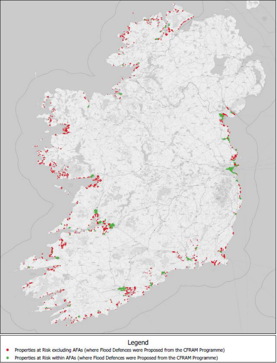
54
Figure 4.1 – National Coastal Change Risk Map – Properties within the Tidal Zone - High End Future
Scenario (HEFS) (Undefended) (Background Map data © 2021 OpenStreetMap)
55
4.6 Review of Relevant Research Identified
The review of the current research available across State organisations has identified that limited
research is available in relation to the monitoring of coastal change and estimating its projected
impact. Therefore the scope of this review was expanded to include European scale research which
is applicable to Ireland. The research identified was grouped into the following categories and is
summarised in Appendix 3.2, with extracts shown in Table 4.4:
Coastal erosion management
Coastal monitoring
Morphological change
Sea level rise
In addition to the research relating to Ireland, research carried out in other countries which is of
interest to Ireland was also collated and a summary is included in Appendix 3.2.
4.7 Additional Research Requirements
Following the review of available research, it is considered necessary that detailed consideration be
given to implementing a coastal change research programme with the following objectives:
To coordinate, fund and manage coastal change research projects relevant to Ireland;
To identify coastal change research priorities and opportunities for Ireland;
To increase collaboration across State organisations and with the education sector;
To provide scientific and technical advice, reports and guidance notes.
A detailed review of the coastal research priorities will need to be carried out to inform any such
coastal change research programme, however, it is considered necessary that the following research
topics at least, identified as part of this review, be considered:
Coastal change resilience;
Coastal change adaptation;
Coastal morphology and potential future changes including identification of coastal sediment
cell and sub-cell boundaries, sediment pathways, sediment sinks and reservoirs;
Managed retreat and managed realignment;
Nature based solutions for coastal change management.
56
Table 4.4 – Summary of Relevant Research Identified
Theme
Title
Description
Funding
Organisation /
Author
Year
Published
Coastal
erosion
management
The EUROSION
Study
EUROSION is a project commissioned by the General Directorate
Environment of the European Commission, which was won by a consortium
led by the National Institute for Coastal and Marine Management of the
Dutch Ministry of Transport, Public Works and Water Management.
EUROSION is based on the assumption that coastal erosion is a phenomenon
that can never be completely controlled but can be managed in an
economically and ecologically sustainable way. The holistic view favoured by
the consortium integrates:
natural and human-induced causes of erosion (storms, seismic
movements, reduced sediment supply from rivers due to dams,
coastal defences themselves, etc.)
different uses of the coast - including both its terrestrial and marine
parts - and ranging from biodiversity and landscape conservation to
tourism, industry and transport
different levels of management - from local to European and
regional seas
river basin considerations
present concerns and long term perspectives (e.g. climate change)
Through supporting the Integrated Coastal Zone Management Practitioners
Network and facilitating access to relevant data and information, EUROSION
offers a follow-up to the EU demonstration program on Integrated Coastal
Zone Management - with an emphasis on pilot projects which focused on
erosion management - and is consequently biased towards ICZM strategies.
European
Commission
2004
57
Theme
Title
Description
Funding
Organisation /
Author
Year
Published
Coastal
monitoring
Coastal Erosion
from Space
The scope of the ESA Coastal Erosion project is
the development and demonstration of innovative Earth Observation (EO)
products founding the basis for long-term exploitation of earth observation
from satellites by large user communities. These applications aim to detect
and track coastal erosion and accretion to inform coastal management
plans.
GSI
Ongoing
Coastal
monitoring
Copernicus Marine
Service Ocean
State Report, Issue
4
The 4th edition of the Copernicus Marine Service Ocean State Report (OSR
4) published in 2020 provides information on changes and variations in the
ocean over the past decades, with a focus on changes in the marine
environment during the year 2018. It is written by 140 scientific experts
from more than 30 institutions and draws from the marine monitoring
capabilities of the Copernicus Marine Service.
von Schuckmann
et. al.
2020
Coastal
monitoring
Coastal Zones
This final version of the Coastal Zones datasets covering 100% of the extent
for reference years 2012 and 2018 together with the accompanying change
mapping, is now available. Please explore the datasets together with
the nomenclature and mapping guidelines for in-depth information.
Copernicus Land
Monitoring Service
Varies
Coastal
monitoring
European Ground
Motion Service
European Ground Motion Service (EGMS) aims to provide consistent,
regular, standardised, harmonised and reliable information regarding
natural and anthropogenic ground motion phenomena over Europe and
across national borders, with millimetre accuracy. EGMS will support
European and national level policies.
Copernicus Land
Monitoring Service
Ongoing

58
5. Key elements of an Irish Coastal Change Strategy
5.1 Key Strategic Pillars
The range of integrated elements of a coastal change strategy and the consequent recommendations
can be categorised under three overarching headings.
Strategic Pillar 1 – Enhancing Governance and Capacity Building
Responding to the impact of climate change on Ireland’s Coast requires, broadly, a dual approach of
both mitigation (tackling the cause) and adaptation measures (reduce the impacts and adaptive
capacity and resilience). This report focuses on adaptation to coastal change.
Given the nature of the risks arising, the broad range of stakeholders with responsibilities to manage
these risks, and the complex legal and regulatory framework within which this must be achieved, there
is clearly a requirement for an integrated and co-ordinated response.
As outlined in Section 2.7 the recommended development of coastal change management plans,
which may transcend Local Authority areas, will require an appropriate policy framework to underpin
and guide potential management options. This will require the development and co-ordination of
policy responses across a range of Government Departments and Agencies.
Investment in capacity building across all key stakeholders is also necessary in order to ensure that
the requisite skills and knowledge are available as required.
Recommendations for this Pillar are set out in Section 5.2.
Strategic Pillar 2 - Understanding the Risk and Identifying Potential Risk Management Options
Scientific evidence and observations are clear that warming of the climate system is unequivocal and
points to the contribution of man-made (anthropogenic) greenhouse gas emissions increasing the
concentrations of carbon dioxide in the atmosphere to levels not experienced in millennia.
Globally, scientific observations show an increase in global mean air and ocean temperatures and
widespread melting of snow and ice, leading to rising sea levels and an increase in the frequency,
intensity and duration of extreme weather events. The negative impacts of climate change are being
experienced in Ireland and will continue and intensify. This is particularly the case with respect to
rising sea levels, which coupled with an increase in the frequency and duration of severe weather
events will have long-term implications for the shape and location of our coastline.
At this point it is known that substantial property and infrastructure risks will arise from coastal
change. While there remains uncertainty over the rate of change and the degree of change at a given
point in time, this must not impede the assessment of the potential risks arising, and the consideration
of adaptive action that may be required to manage these risks.
Strategic pillar 1
• Enhancing
Governance and
Capacity Building
Strategic pillar 2
• Understanding the
Risk and Identifying
Potential Risk
Management Options
Strategic pillar 3
• Developing
Management
Responses to Coastal
Change

59
A co-ordinated programme of monitoring and research, drawing from and contributing to EU and
international research, is required in order to ensure that the best available estimates of potential
coastal change and associated hazards and risks are identified, refined and updated on an ongoing
basis. This will inform the development of technical options to manage such risks.
Recommendations for this Pillar are set out in Section 5.3
Strategic Pillar 3 - Developing Management Responses to Coastal Change
At the heart of the challenge of coastal change risk management there is a need for a strategic coastal
management framework. In broad terms, this has been articulated commonly in many jurisdictions
as encompassing a range of approaches, as listed below, which can be applied individually or in
combination at the local, regional and national level.
Do nothing
No active intervention, allowing natural processes to take over with
areas of land being lost to the sea over time
Hold the line
Build or maintain coastal defences to protect a coastline against the
impacts of sea level rise and coastal erosion
Managed realignment
Landward realignment of existing coastal defences, or an existing
coastline, to a new, more sustainable alignment accounting for the
impacts of coastal change
Managed retreat
Co-ordinated movement of people and infrastructure away from risks
and allow the coastline to retreat
Advance the line
Defences are built out at sea e.g. tidal barrage, land reclamation
Whilst there is a requirement to identify and manage future risks arising from coastal change, there
are areas where coastal change is currently impacting communities and households across the State.
Developing longer-term management responses will be guided by the evolving approach to dealing
with extant risks. The recommendations outlined in Section 5.4 are centred on developing those
Management responses over the short, medium and longer terms.
5.2 Enhancing Governance and Capacity Building
5.2.1 Roles, Responsibilities and Interactions of Key Stakeholders at National, Regional and Local
Scales
The development of the State’s response to the challenge of coastal change requires a multi-agency /
department response. Consideration is needed as to how best to efficiently and effectively co-ordinate
the State’s response.
At the national level there are a range of Departments with significant policy and funding roles relating
to coastal change. A lead department / agency should assume a coordination role, to promote joined-
up, whole of Government policy responses to coastal change across the various Departments and
agencies with policy responsibilities.
There is a dynamic interrelationship between policy development, operational/ programme matters
and permitting processes that must be successfully managed. In this context, there is a need for the
immediate establishment of an interdepartmental steering group to identify possible approaches,
associated resource requirements, and develop the range of policy responses that this challenge
60
encompasses. This should be chaired by the lead Government Department/Agency. Appropriate
support arrangements, including the provision of additional resources, will be necessary, in order to
efficiently and effectively support the management of this complex and multi-faceted work.
In order to ensure appropriate cross-Governmental oversight, progress on the work of this inter-
departmental steering group should be reported to the Cabinet Sub Committee on the Environment
and Climate Change, through the relevant Senior Officials Group.
As the management response to coastal change will affect coastlines across multiple local authority
jurisdictions, the appointment of a national technical agency to lead on the assessments of coastal
change hazards and risks and the assessment of technical options and constraints would deliver
economies of scale. The outputs of such work would inform national, regional and local coastal change
policy development and coastal change management planning.
At the local level coastal local authorities have an important role to play in developing local policy,
programmes of action and community and political participation. The identification and scoping of
additional support for local authorities is required particularly in training, programme support and in
deepening the expert technical, environmental and administrative capacity.
The CAROs, supporting local authorities at a regional level and in cooperation with Government
Departments and national agencies, could provide expert technical / research support, training and
development of consistent policy and programme approaches across local authorities.
A key need is for ongoing support, capacity building and practical expert and administrative learning,
and knowledge sharing which is a vital requirement across administrations, particularly at an EU level.
In order to capitalise on the need for expert support there is an opportunity to engage an advisory
support body made up of international experts in a range of relevant fields (e.g. engineering,
environmental, communications). This expert group could assist the State in formulating policy at a
strategic level and allow such a strategy to be responsive to changes, new learnings and best
international practice as it is implemented.
Any strategy put in place in relation to responding to sea level rise and increasing storm
frequency/intensity and its effects on our national coastline needs to be capable of reflecting new
international learnings and technical innovations.

61
Recommendation 1 - Governance
a) The Department of Housing, Local Government and Heritage be designated the lead
coordination role, to promote a joined-up, whole of Government response to coastal
change by all relevant Departments / Agencies having regard to their existing policy remits
and to chair the Interdepartmental Steering Group outlined below.
b) An Interdepartmental Steering Group on Coastal Change be immediately established to
identify possible approaches, associated resource requirements, and to develop the range
of policy responses that the challenge of coastal change encompasses. Additional
resources should be provided to support the work of this Group.
c) The Department of Housing, Local Government and Heritage should report on the work
of the Interdepartmental Steering Group to the Cabinet Sub-committee on Environment
and Climate Change, through the Senior Officials Group.
d) The Office of Public Works (OPW) be designated as the national lead coordinating body
for the assessment of coastal change hazards and risks and the assessment of technical
options and constraints outlined in Recommendations 3 to 7 below. It is also
recommended that the OPW should be represented on the Senior Officials Group.
e) An advisory group of national and international experts including engineering,
environmental, heritage and communications experts be established by the Department
of Housing, Local Government and Heritage. It is suggested that this group be
independently chaired.
f) The Interdepartmental Steering Group should engage at an EU and bilateral level with
neighbouring jurisdictions to examine best practice, lessons learned and to update
knowledge.
g) Existing legislation should be reviewed to consider appropriate amendments to align with
these recommendations.
h) The CAROs, in conjunction with relevant agencies, should establish a training and
development programme for local authority staff.
i) The CAROs should identify and scope, in conjunction with the Interdepartmental Steering
Group and the LGMA, the requirement for additional expert technical, environmental and
administrative capacity at local authority level.
5.2.2 Skills and Knowledge
The implications of coastal change will require the strengthening of a range of skill sets for example
engineering, coastal modelling, environmental. In the short term consideration should be given to
identifying the required skill sets both at a central and local authority level. With respect to particular
expert skill sets that are already limited in number, such as coastal modelling, consideration should be
given to enhancing capacity within a national organisation. With respect to improving local authority
skill sets, the CAROs are undertaking a range of training programmes in this space, which need to
continue and should encompass coastal change.
However, in the medium and long term there will be a continued demand for a range of specialist skill
sets to operationalise the mitigation of the effects of sea level change. As part of a skill set
identification programme, engagement and collaboration is needed with the third level education
sector to establish and develop suitable programmes for the training and development of needed
skills sets. The identification of necessary skill sets needs to be undertaken rapidly to allow for the
evolvement of existing courses and the possible establishment of new courses in our third level and
other training centres.

62
Recommendation 2 – Capacity Development
a) The Interdepartmental Steering Group should undertake an analysis at the local authority
level and within relevant national-level Departments / agencies of the relevant skills and
resources available and required to implement the adopted policies and strategies for
coastal change management.
b) The Interdepartmental Steering Group should develop, through collaboration between
relevant authorities and agencies, the third-level institutions and other relevant
stakeholders, the programmes necessary to develop the required skill sets and resources
nationally for coastal change management in the long-term.
5.3 Understanding the Risk and Potential Risk Management Options
5.3.1 Building the Data and Knowledge Base
In seeking to develop a policy framework that guides and informs the making of these choices, a
programme of practical actions must be built on the vital need for high quality and comprehensive
coastal information to be collated and maintained. In this regard, a systematic programme for the
gathering, collating, mapping and publication of relevant coastal geo-spatial datasets needs to be
established and importantly these datasets need to be maintained on an ongoing basis, as has been
identified in Chapter 4. This builds on the work already underway by various State agencies, and the
key recommendations are summarised below.

63
Recommendation 3 - Coastal Monitoring and Data Collection
a) The OPW be designated as the lead body for co-ordinating the monitoring of physical
coastal change, to include the gathering, collation, mapping and analysis of geo-spatial
and other relevant datasets. The OPW, once suitably resourced with the relevant
suitably qualified staff, would be responsible for developing and coordinating an
ongoing national coastal change monitoring programme to facilitate national scale
assessments for the identification of areas of risk to be monitored in detail, and then for
such areas:
Determining the level of monitoring required at each location where detailed
assessment should be undertaken, and coordinating the required monitoring.
Specifying, collecting, storing and disseminating all data, including aerial
photography, oblique imagery, LiDAR, beach topographic survey data, bathymetric
data, wave data and tidal data required to adequately monitor the coastline.
Undertaking, coordinating and promoting research in the area of coastal change
monitoring and implementation of innovative monitoring methodologies.
This data collated should be stored centrally and be made available where appropriate
to stimulate new research and innovation that may be possible based on the availability
of this essential coastal monitoring data.
b) Support the work of Met Eireann to produce a Coastal Flood
Forecast Service for Ireland that will aim to
produce authoritative tide tables
develop the best coastal flood forecast models for Ireland
expand the observation network in terms of tide gauges, wave radars and near shore
wave buoys/sensors.
In addition to data on the physical characteristics of the coast, and how it is changing, assessments of
risk and the consideration of options for the management of that risk need to take into account the
existing measures that are in place, such as coastal defences, both natural and man-made and their
condition.
Recommendation 4 – Coastal Defence Asset Database
a) The OPW to establish and maintain a National Coastal Defence Asset Database of
relevant regional and local coastal infrastructure for the coast of Ireland. This database
should be sufficiently detailed to capture all coastal defences, both natural and human-
made, at a scale suitable for use in the assessment of hazard and risk associated with
coastal change, including their location, purpose, physical dimensions and condition.
b) Coastal defence owners to plan and undertake a programme of inspection to identify
the condition of existing coastal defences with a particular emphasis on those defences
that are in public ownership, located in settlements, or that are providing an important
coastal defence function.
c) Coastal defence owners to plan and prepare a programme of necessary remediation /
maintenance, where necessary, arising from the prior inspection and condition surveys
under the programme of inspection.
Research is required to support the collation of relevant data and the assessment of existing defence
assets, and to inform both the assessment and management of potential future coastal change

64
hazards and risks. A body of international and national research has been identified by the TWG, as
set out in Section 4.6. This body of existing research may need to be supplemented by targeted, topic
or Ireland-specific further research, as set out in Section 4.7.
Recommendation 5 – Coastal Change Research Programme
a) Development and implementation of a comprehensive coastal change research
programme by the OPW to meet the identified range of objectives to support the
assessment and management of coastal change.
5.3.2 Assessing the Coastal Change Hazard and Risk
Working with available and readily-derivable information in the short-term, and then with the
additional data and knowledge collated and developed as above, it is essential that assessments are
undertaken to identify where coastal change is already occurring and where it may happen in the
future, and to what degree, and then to assess where such change may become a potentially
significant risk. In line with the flood risk assessment and management framework set out in the EU
‘Floods’ Directive, this should be undertaken as a national screening exercise in the first instance, to
identify the existing and potential future ‘hot-spots’ of potentially significant risk.
It is important that the level of risk arising from future coastal change be assessed for key
infrastructure, archaeological and heritage sites. In this regard there is a need to identify the key
infrastructure, particularly those in public ownership, and archaeological and heritage sites, that are
at potential risk.

65
Recommendation 6 - National Assessment of Coastal Change Risk
a) The OPW to develop national-scale coastal erosion hazard mapping and an associated
risk assessment using the latest available data and methodologies. This mapping should
include an assessment of the potential impact of a range of sea level rise scenarios on
coastal erosion rates to ensure areas at highest risk of erosion due to climate change can
be identified. To monitor ongoing change and the associated risk from coastal erosion,
and to improve the assessment using the most up-to-date data, knowledge and
methodologies, this national scale assessment should be reviewed at regular intervals,
e.g. every six to twelve years, and the erosion hazard mapping and risk assessment
updated if/as necessary.
b) The OPW to map the potential movement of the inter-tidal zone, and assess the risks
associated with such movement to communities.
c) The OPW to undertake an assessment to identify the communities and coastal areas at
potentially significant risk from coastal change, both now and in the future, making use
of historic data, predictive assessments and consultation with key stakeholders such as
the local authorities. This assessment should include the identification of the habitats,
cultural heritage and other sectoral assets at risk from coastal change.
d) Each relevant sector and organisation shall identify infrastructure and other assets at
risk under future coastal change scenarios, as part of the national assessment of coastal
change risk, including analysis of coastal archaeological sites and wrecks to assess the
likely effects of coastal change.
e) The OPW to undertake detailed risk analysis, at the scale of the sediment cell and/or
sediment sub-cell, for the locations identified as being at potentially significant coastal
change risk, with a particular focus on affected urban settlements.
5.3.3 Assessing the Technical Options for Managing Coastal Change Risk
Planning for the management of coastal change would benefit from a comprehensive, proactive and
consistent assessment of potentially viable options for managing the existing and potential future risks
arising from erosion and coastal change. This would require an assessment of the areas of potentially
significant risk in more detail to gain a comprehensive understanding of the potential risks, rate of
change and associated uncertainties to inform potential technical options for managing the risk. Such
work would inform appropriate policy responses in terms of planning for coastal change management,
and is expected to include identifying, for example, areas where a ‘hold the line’ or ‘advance the line’
response could have detrimental impacts elsewhere along the coast due to the sediment dynamics
within the coastal cell, where the risks are such that investment in new physical defences is warranted,
or where such defences would not be viable and sustainable and alternative approaches may be
required and/or existing defences may need to be removed. Such a programme should consider hard
and soft defence options as well as nature-based defences, such as a programme of dune
management, protection, and where appropriate strengthening, to support the defence of vulnerable
locations, and also the proactivity and physical implications of a programme of beach replenishment.
Undertaking such work at this scale would be novel in Ireland, and implementation at a national scale
would benefit from a pilot application to test methods and approaches and assess costs, programme,
risks and opportunities.

66
Recommendation 7 - Assessment of Technical Risk Management Options
a) The OPW to identify, assess and appraise technical options and constraints, in
consultation with local communities, to inform decisions on the management of coastal
change risks in relevant areas and the long-term planning for the management of
potential future change.
b) The OPW to undertake a pilot project for such work to inform the national
implementation programme.
5.4 Developing Management Responses to Coastal Change
5.4.1 Addressing Short-Term Issues
While there are a range of policies, strategies and programmes that may be put into place over the
medium to long-term, it is recognised that there are current and urgent issues to address in parallel
to the implementation of the medium to long-term recommendations that are adopted.
In particular, there are a number of very vulnerable locations which have required and will continue
to require specific interventions. An example of this is Portrane, County Dublin which has required a
bespoke intervention in response to rapid erosion brought on by relatively recent increases in
nearshore wave energy and conditions. Arising from these interventions there is a need to reflect and
incorporate learnings in order to improve the scope, capacity and timing of responses.
In that regard there are a number of clear immediate requirements:
to fully understand the scale and extent of the most immediate vulnerable locations;
to consider what responses should be deployed, where the type and scale of such responses
should form part of the consideration of the trialling of interventions, learnings should be
recorded and integrated into future policy/project responses;
to investigate the most appropriate means of communicating and deploying interventions
with affected communities, which may include how best to sensitively approach the
abandonment of property where necessary.
In essence, there is a defined need for short-term immediate interventions, and where these are
necessary, they form the basis for the operational development of a long-term programme of
responding to coastal change.
The Department of Housing, Local Government and Heritage, local authorities, the OPW, planners and
all stakeholders that currently have a role with regard to assessing and managing coastal change
should continue to discharge their existing functions to address immediate issues and plan for
potential future change taking account of the information available at that time.

67
Recommendation 8 – Short-term measures
a) In already identified vulnerable locations, local authorities and State agencies should
continue to engage with local communities to ascertain the most appropriate
interventions. Policy issues arising should be brought to the Interdepartmental Steering
Group for consideration and action.
b) Local authorities, in statutory plans, including the LA Climate Action Plans required
under the Climate Act, should continue to identify potentially vulnerable locations that
could be affected by coastal change. It is recommended that statutory plans in such
cases put in place spatial policies to limit development in the interests of not increasing
the amount of development and consequent population at risk from imminent coastal
change.
c) The CAROs should continue to engage in skills training associated with improving and
deepening the local authority and State agencies capability to respond to the effects of
coastal change. This training should include both the impact of coastal change on coastal
and underwater archaeology and the impact of coastal defences and other measures on
archaeological sites.
d) The CAROs should continue in association with State agencies, particularly the OPW and
Geological Survey Ireland, to carry out appropriate research and evidence gathering to
inform the establishment of a long-term programme of response to coastal change.
5.4.2 Risk Management Response
Arising from the identification of at risk locations and building on the assessment of technical options
for the management of coastal change risks, the IDG recommends the initiation of a pilot programme
to test the most effective risk management response options/methods within a defined policy
framework established by the interdepartmental steering group to manage the risk from coastal
change for a given area, including the preparation of a pilot coastal change management plan.
A national programme of coastal change management planning, informed by the relevant technical
assessments, should then be developed, building on the pilot programme, to define a strategy and
relevant policies for the management of coastal change, within a defined policy framework that will
be cross-sectoral in nature that should both inform and be in line with the National Adaptation
Framework, National Planning Framework, National Marine Planning Framework, Regional Spatial and
Economic Strategies and relevant County/City Development Plans and Local Area Plans.

68
Recommendation 9 – Coastal Change Management Planning
a) The Interdepartmental Steering Group should initiate a pilot programme to identify the
most effective risk management response option(s)/method(s) within a defined policy
framework and prepare a pilot coastal change management plan.
b) The Interdepartmental Steering Group should apply the defined policy framework to
potentially at-risk coastal cells and sub-cells around the country and, in consultation
with local communities and other stakeholders, prepare a national set of coastal change
management plans.
c) Arising from suitable risk based analysis, each relevant sector and organisation to
identify appropriate measures to address the risk e.g. structural or non-structural
measures or relocation of existing infrastructure to a less vulnerable location.
5.4.3 Delivery of Capital Coastal Change Management Plan Measures
As part of the broader plan for managing coastal change, a national programme of capital investment
may be required over the coming decades to manage risk for particular areas where physical
intervention, e.g., hold-the-line, has been identified as the appropriate response.
The owners and operators of such infrastructure will be required to identify how coastal change risks
to existing infrastructure will be managed. Furthermore, as part of the renewal or developing of new
infrastructure that takes account of the potential long-term impacts of coastal change, including
whether it is practical or required to instead relocate assets to less vulnerable locations, shall be
undertaken at an early stage in the design process.
Recommendation 10 – Coastal Change Management Delivery
a) With regard to the implementation of capital works in the context of the coastal change
management plans, a programme of capital measures should be prepared by the
Interdepartmental Steering Group, as determined appropriate through the joined-up,
whole of Government response for the management of potential future coastal change.
i. The OPW should manage and coordinate the implementation of any such
programme of capital measures to protect communities.
ii. Each sector to implement the capital and other technical measures with regards
to the management of risk to their sectoral assets and objectives.
5.4.4 Nature-based Solutions
As set out in Section 3.5, Nature-based solutions can and should have a role to play as part of an
integrated, multi-sectoral approach in managing coastal change, which will further the development
of knowledge in Ireland of the techniques available, and the promotion of application by all parties.
Recommendation 11 – Promotion of Nature-based Solutions
a) The Interdepartmental Steering Group should build a suitable body of knowledge of the
application of nature-based solutions as a means for managing coastal change through
assessments of national and international work to date, research and pilot studies, as
necessary.

69
b) The Interdepartmental Steering Group should identify locations around the coast of
Ireland where nature-based solutions may provide solutions and benefits in the areas of
potentially significant risk from coastal change.
c) Interdepartmental Steering Group should promote a multi-sectoral approach to the
application of nature-based solutions in the coastal environment to achieve multiple
benefits in conjunction with local communities.
5.4.5 Planning Policy
There is a need for spatial planning guidelines supported by capacity building to assist coastal local
authorities in supporting and enabling appropriate resilient and sustainable development that
considers risk from coastal change in a structured way and avoids further development in areas
considered on the basis of evidence to be at risk. It is envisaged that this structured approach will be
modelled on the framework adopted for the Guidelines on the Planning System and Flood Risk
Management (DHLGH/OPW, 2009) and other relevant guidelines. These spatial planning guidelines
will take account of national planning policy; the location of existing development and give advice on
the development of spatial planning policy that takes account of coastal zone and integrated coastal
management principals in the context of future development, the effects of coastal change, and the
steps that can be taken to mitigate its effects. This terrestrial coastal change planning guidance needs
to be linked with marine planning guidance arising from the National Marine Planning Framework.
Recommendation 12 – Planning Guidelines
a) The Department of Housing, Local Government and Heritage should prepare and publish
spatial planning guidelines to give policy direction to Planning Authorities in coastal areas
that may be subject to coastal change, taking account of environmental implications and,
based on the framework adopted for the Guidelines on the Planning System and Flood
Risk Management, seek to avoid inappropriate new development in at risk coastal
locations.
Recommendation 13 – Consider legislative options
a) Consideration should be given by the Department of Housing, Local Government and
Heritage as to how future beach nourishment and re-nourishment projects involving the
need to transfer large volumes of sand, shingle or aggregate from offshore or nearshore
locations to either nearshore or upper foreshore can be more effectively permitted or
licenced under the relevant legislation. This future need should balance the identified
need for the coastal project as a defence measure with other considerations such as
environmental impact.
b) Consideration should be given by the Interdepartmental Steering Group to legislative
changes that recognise the complex nature of any programme or project necessary to
mitigate or manage the impacts of coastal change.

70
5.4.6 Coastal State’s Maritime Area
In international law, the maritime zones over which a coastal state has jurisdiction are measured from
a baseline. For instance, the territorial sea may extend to a maximum distance of 12 nautical miles
measured from the baseline, while its exclusive economic zone extends from the outer limit of the
territorial sea to a maximum distance of 200 nautical miles measured from the baseline.
The ‘normal baseline’ is the low-water mark along the coast of the mainland or any offshore island of
the state, or of any low tide elevation located within 12 miles of the mainland or an island. ‘Straight
baselines’ may be drawn where the coastline is deeply indented or where there is a fringe of islands
in the immediate vicinity of the coast. In certain circumstances, a ‘closing line’ may be drawn across
the mouth of a bay and the baseline established from this closing line.
Because of the configuration of the Irish coastline, straight baselines have been drawn around the
west and south coasts of Ireland. In contrast, with the exception of three bay closing lines, the baseline
along the east coast is the low water mark.
A coastal state’s territorial sea may extend to a maximum distance of 12 nautical miles from that
state’s baseline. A state’s exclusive economic zone extends from the outer limit of its territorial sea to
a maximum distance of 200 nautical miles measured from its baseline.
As sea-levels rise globally, the low water mark along a coast may recede landward. This, in turn, may
therefore have implications for the seaward extent of a state’s maritime jurisdiction. This aspect of
sea-level rise is receiving increasing attention internationally. The United Nations International Law
Commission (ILC) is examining the international law issues raised by the phenomenon of sea-level rise.
Ireland has addressed the issue in statements on the work of the ILC at the UN General Assembly Sixth
Committee.
Recommendation 14 – Coastal State’s Maritime Area
The Department of Foreign Affairs, in consultation with the Department of Housing, Local
Government and Heritage as appropriate, should continue to engage with the
United Nations International Law Commission to examine the international law issues raised by the
phenomenon of sea-level rise.
a) The Department of Housing, Local Government and Heritage should consider - in consultation
with the Department of Foreign Affairs – the impact, if any, of sea level rise on Ireland’s maritime
boundaries in future mapping exercises.
b) The Department of Housing, Local Government and Heritage should engage with coastal
local authorities and the Chief Boundary Surveyor to agree a process for updating each local
authority maritime boundary area as well as low and high water marks, particularly in light
of their enhanced role in the maritime area under the Maritime Area Planning Act 2021.
5.4.7 The Significant Challenge of Implementing Strategic Managed Retreat
Even with comprehensive monitoring systems and a policy of appropriate intervention, it is inevitable
that, as a State, we will be faced in some circumstances with the need to co-ordinate a managed
retreat strategy, as the safest, most appropriate response in certain cases to rising sea levels and the
associated impact on the national coastline.
This is a difficult and complex intervention. However, by not taking steps to recognise and ameliorate
its difficulties the State will likely be faced with an uncoordinated, reactive or emergency response to
unfolding events, e.g., immediately following or during major coastal storm events.

71
Measures and mechanisms will have to be put in place to allow for a considered response that
recognises at its heart that it is people and communities that have to be made safe and sustainable,
and hence potentially requiring their relocation. In this regard, there is a strong need for engagement
between the State agencies, the relevant local authorities and the local communities and relevant
stakeholders when considering a managed retreat strategy.
As a core objective, arising from a comprehensive monitoring and evidence gathering programme,
those locations at high risk from coastal change and potential locations where managed retreat may
be feasible or necessary will need to be identified at an early stage.
Planning policy at a local level needs to be informed to avoid the intensification of uses in the locations
affected, so as to ameliorate the scale of response required. Local planning policy in areas where this
approach may be required should also be directed to facilitate the movement of population.
Given the relative time scales, measured in years, if not decades, interventions could be made to
extend the period of time before a managed retreat option is required. This would allow for a more
extended period for relocation.
There is a wider need for the State to consider the most appropriate support measures that would be
required to underpin a managed retreat option.
Recommendation 15 – Developing Managed Retreat Options
a) Consideration should be given by the Interdepartmental Steering Group to identifying the
most appropriate measures and mechanisms required to support a managed retreat
option for communities and/or individual homes and properties at risk from coastal
change, including ensuring an adequate time period for consideration and
implementation where appropriate of managed retreat and the timescale required for
effective movement of at risk communities, where deemed necessary.
b) A communications and consultation process should be put in place with the effected
communities, led by the local authority, over an extended time period.
c) Planning policy at a local level should reflect the risk and avoid intensifying existing
development uses or locating new inappropriate development within the zone(s)
assessed to be most at risk from coastal change and potential locations where managed
retreat may be feasible or necessary. Furthermore planning policy should be aligned,
where necessary, to facilitate managed retreat particularly with respect to the location of
new replacement dwellings / structures / development.

72
References
Bakker, A.M.R., Wong, T.E., Ruckert, K.L. et al., 2017. 'Sea-level projections representing the deeply
uncertain contribution of the West Antarctic ice sheet', Scientific Reports 7(1), pp. 3880.
Bord Iascaigh Mhara, 2021. The Business of Seafood – A Snapshot of Ireland’s Seafood Sector 2021
CIRIA, 2010. Beach management manual (second edition).
Climate Change Advisory Council, 2022. Annual Review 2022.
Central Statistics Office, 2017. Census of Population 2016 – Profile 2 Population Distribution and
Movements. https://www.cso.ie/en/releasesandpublications/ep/p-cp2tc/cp2pdm/
Department of Environment, Climate and Communications, 2021. Climate Action Plan 2021.
DeConto, R. M., Pollard, D., Alley, R. B., Velicogna, I., Gasson, E., Gomez, N., Sadai, S., Condron, A.,
Gilford, D. M., Ashe, E. L., Kopp, R. E., Li, D. and Dutton, A., 2021. 'The Paris Climate Agreement and
future sea-level rise from Antarctica', Nature 593(7857), pp. 83–89
(https://www.nature.com/articles/s41586-021-03427-0.
Department of Housing, Local Government and Heritage, 2021. National Marine Planning
Framework
Department of Housing, Planning and Local Government, 2018. National Planning Framework
European Environment Agency, 2021. Global and European sea level rise.
https://www.eea.europa.eu/ims/global-and-european-sea-level-rise
European Commission, 2021. The solution is in nature. Future Brief 24. Brief produced for the
European Commission DG Environment. Bristol: Science Communication Unit, UWE Bristol.
European Commission, 2020. ‘Nature-Based Solutions’ www.ec.europa.eu/info/. Available at:
https://ec.europa.eu/ research/environment/index.cfm?pg=nbs
European Commission, 2004. Eurosion Project. http://www.eurosion.org/
Fox-Kemper, B., Hewitt, H. T., Xiao, C., Aðalgeirsdóttir, G., Drijfhout, S. S., Edwards, T. L., Golledge,
N. R., Hemer, M., Kopp, R. E., Krinner, G., Mix, A., Notz, D., Nowicki, S., Nurhati, I. S., Ruiz, L.,
Sallée, J.-B., Slangen, A. B. A. and Yu, Y., 2021. 'Ocean, cryosphere, and sea level change', in:
Masson-Delmotte, V., Zhai, P., Pirani, A., et al. (eds), Climate Change 2021: The Physical Science
Basis. Contribution of Working Group I to the Sixth Assessment Report of the Intergovernmental
Panel on Climate Change, Cambridge University Press.
Hansom, J.D., Fitton, J.M., and Rennie, A.F., 2017. Dynamic Coast - National Coastal Change
Assessment: Coastal Erosion Policy Context, CRW2014/2.
Kopp, R. E., DeConto, R. M., Bader, D. A., Hay, C. C., Horton, R. M., Kulp, S., Oppenheimer, M.,
Pollard, D., Strauss, B. H., 2017. 'Evolving understanding of Antarctic ice-sheet physics and
ambiguity in probabilistic sea-level projections', Earth’s Future 5(12), pp. 1217–1233.
Mengel, M., Nauels, A., Rogelj, J. et al., 2018. 'Committed sea-level rise under the Paris Agreement
and the legacy of delayed mitigation action', Nature Communications 9(1), pp. 601.
Mulder, J., Bucx, T., O’Hagan, A.M. and Gault, J., 2010. Concepts and Science for Coastal Erosion
Management (CONSCIENCE). Review of Existing Knowledge and Management Approaches of Coastal
Erosion. Deliverable D8.

73
Nerem, R. S., Beckley, B. D., Fasullo, J. T., Hamlington, B. D., Masters, D., Mitchum, G. T., 2018.
'Climate-change-driven accelerated sea-level rise detected in the altimeter era', Proceedings of the
National Academy of Sciences of the United States of America 115(9), pp. 2022–2025.
Oppenheimer, M., Glavovic, B., Hinkel, J., van de Wal, R., Magnan, A. K., Abd-Elgawad, A., Cai, R.,
Cifuentes-Jara, M., DeConto, R. M., Gosh, T., Hay, J., Isla, F., Marzeion, B., Meyssignac, B.,
Sebesvari, Z. and Sugyiama, T., 2019. 'Chapter 4: Sea level rise and implications for low lying islands,
coasts and communities', in: Pörtner, H.-O., Roberts, D. C., Masson-Delmotte, V., et al. (eds), IPCC
special report on the ocean and cryosphere in a changing climate, Cambridge University Press,
Cambridge, UK.
Office of Public Works, 2019. Flood Risk Management Climate Change Sectoral Adaptation Plan
Palmer, M. D., Domingues, C. M., Slangen, A. B. A. and Dias, F. B., 2021. ‘An ensemble approach to
quantify global mean sea-level rise over the 20th century from tide gauge reconstructions’,
Environmental Research Letters 16(4), pp. 044043 (https://doi.org/10.1088/1748-9326/abdaec)
accessed November 30, 2021.
Risc-Kit. Case Studies. https://www.coastal-management.eu/governance.html
RPS Consulting Engineers, 2010. Final Technical Report ‘ICPSS, Phase 2, Work Packages 2, 3 & 4A,
Strategic Assessment of Coastal Flooding and Erosion Extents – South East Coast – Dalkey Island to
Carnsore Point Pilot Area’
RPS Consulting Engineers, 2010. Final Technical Report ‘ICPSS, Phase 3, Work Packages 2, 3 & 4A,
Strategic Assessment of Coastal Flooding and Erosion Extents – North East Coast - Dalkey Island to
Omeath’
RPS Consulting Engineers, 2010. Final Technical Report ‘ICPSS, Phase 3, Work Packages 2, 3 & 4A,
Strategic Assessment of Coastal Flooding and Erosion Extents – South Coast - Carnsore Point to
Bantry Bay’
RPS Consulting Engineers, 2013. Technical Report ‘ICPSS – Phase IV, Work Packages 2, 3 & 4A,
Strategic Assessment of Coastal Flooding and Erosion Extents – South West Coast - Bantry Bay to
Ballyvaghan Bay’
RPS Consulting Engineers, 2014. Technical Report ‘ICPSS – Phase IV, Work Packages 2, 3 & 4A,
Strategic Assessment of Coastal Flooding and Erosion Extents – West Coast - Ballyvaghan Bay to
Killala Bay’
RPS Consulting Engineers, 2014. Technical Report “ICPSS – Phase IV, Work Packages 2, 3 & 4A,
Strategic Assessment of Coastal Flooding and Erosion Extents – North West Coast - Killala Bay to
Lough Foyle”
RPS Consulting Engineers, 2020. Irish Coastal Wave and Water Level Modelling Study 2018 Phase 1 –
Extreme Water Levels
von Schuckmann et al, 2020. Copernicus Marine Service Ocean State Report, Issue 4, Journal of
Operational Oceanography, 13:sup1, S1-S172, DOI: 10.1080/1755876X.2020.1785097
WCRP Global Sea Level Budget Group, 2018. 'Global sea-level budget 1993–present', Earth System
Science Data 10(3), pp. 1551–1590 (https://www.earth-syst-sci-data.net/10/1551/2018/) accessed
November 9, 2018.
74
Appendices

75
Appendix 1:
Terms of Reference of Inter-Departmental Group on Managing Coastal Change
Inter-Departmental Group to initially scope out an approach for the development of
an integrated, whole of Government coastal change management strategy and
report back to Government with its initial findings and recommendations. It is
envisaged that the scoping report will address:-
o Approaches to coastal change management in EU and other
jurisdictions;
o Baseline and other data capture and research requirements to inform
developing, implementing and monitoring a national coastal
management strategy, to include potential damages assessment;
o Outline of the economic, environmental, cultural and social policy
issues arising with approaches to coastal change management;
o Criteria that can help inform planning and investment decisions on
future use of all coastal areas, including any guidance requirements;
o Recommendations on future structures and roles of Government
Departments to deal with coastal change and to deliver a national
coastal change policy, including adaptation strategies, resource
implications, legislative and regulatory change requirements and a
communications strategy to underpin it.

76
Appendix 2:
Appendix 2.1: Coastal Management Case Studies from RISC-KIT (sections 2.2, and
2.4 to 2.7), Dynamic Coast (section 2.3) and the CONSCIENCE projects
A.2.1 United Kingdom – England
A.2.1.1 Overview
The United Kingdom of Great Britain and Northern Ireland (UK) is bordered by four seas: to the
south by the English Channel, which separates it from continental Europe; to the east by the North
Sea; to the west by the Irish Sea; and the Atlantic Ocean.
Around 78% of the population (50.885.219 inhabitants) live in coastal regions
1
, as compared with
the EU-28 average of 42% (Eurostat, 2015).
2
One hundred and thirty five of the UK's one hundred
and seventy three upper tier (or groups of lower tier) authorities are coastal.
3
The United Kingdom (UK) is an asymmetrically decentralised unitary state, comprised of England
and three countries with devolved governments: Scotland, Northern Ireland and Wales. The UK
Parliament retains absolute sovereignty, while the Scottish Parliament, the Northern Ireland
Assembly and the National Assembly for Wales, each has a differing degree of devolved legislative
powers (CoR, 2012). There are three legal systems within the UK: 1) England and Wales 2) Northern
Irish and 3) Scottish.
Successive reforms have produced a complex set of bodies which are responsible for delivering
public services at the local level in the UK (CoR, 2012).
The remainder of this section focuses on the governance system in England.
In some parts of England, local government is divided into a two-tier system, split between county
councils at the upper tier and district councils at the lower tier. Each tier is responsible for different
services, although they overlap in some matters (Sandford, 2017). In other areas there is no tiered
system, and 'unitary authorities' carry out all local government functions. In total, England has 353
local authorities: 27 county councils; 201 district councils; and 125 unitary authorities (Sandford,
2017).
A number of national organisations have been established by central government to carry out
functions and/or distribute funding in England and Wales (e.g. the Environment Agency, Natural
England and the Homes and Communities Agency). Although many local authorities may have
working relationships with these bodies, they are not accountable to local government (Sandford,
2017).
A.2.1.2 Governance of Coastal Zones
GeneralCoastal policy development in England takes place at different administrative levels and with
different focus:
At national level Defra prepared a draft national ICZM strategy with UK-wide policy
objectives based on a common set of guiding principles, which can be applied in a flexible
manner at local level;
At regional level, 49 Shoreline Management Plans (SMPs) have been developed combining
multiple local authorities and focusing on identifying appropriate policy options;
At local level Coastal Defence Strategy Plans are developed in order to implement tailored
solutions/measures for local coastal issues.

77
These authorities execute the legislative framework for the coastal management. At all levels the
issue of coastal erosion is being addressed by employing an integrated portfolio of approaches which
reflect both national and local priorities, so as to:
reduce the threat to people and their property; and
deliver the greatest environmental, social and economic benefit, consistent with the
Government's sustainable development principles.
Coastal Protection and Management
Coastal protection is a district level responsibility and it has been the role of local authorities to
manage coastal protection since the passing of the Coast Protection Act 1949. Under the 2009
Marine and Coastal Access Act a Marine Management Organisation (MMO) was established to
coordinate planning, licensing and enforcement in English marine areas.
Spatial planning is a responsibility at both county and district level. It is a requirement that local
authorities and other public bodies to work together on planning issues of mutual interest. English
seas are split into 10 plan areas. A "Description of the Marine Planning System for
England” produced by the Department for Environment, Food and Rural Affairs (Defra) in 2011
outlines the marine planning system in England.
In 2013, the Coastal Concordat for England was signed by three different UK Government Ministries
and several public bodies. The concordat is an agreement that aims to streamline and coordinate
planning processes for development in coastal zones. The concordat is to be implemented by the
main regulatory and advisory bodies (the Marine Management Organisation, the Environment
Agency, Natural England) in collaboration with coastal Local Planning Authorities.
Key documents outlining the management of coastal risk around the coastlines of England and
Wales are the Shoreline Management Plans (SMPs). These Plans, which are now in their second
generation, are advisory - non statutory - large-scale assessments of the risks associated with coastal
processes which seeks to reduce these risks to people and the developed, historic and natural
environments. SMPs also assist Local Planning Authorities who are required to have a proportionate
and sufficient evidence base on coastal change to inform their decision-making.
SMPs are led either by the local council or UK Environment Agency in ‘Coastal Groups’ and identify
the most sustainable approach to managing the flood and coastal erosion risks to the coastline over
3 epochs: short term (to 2025); mid-term (2025 – 2055); and long term (2055 – 2105).
Each SMP has an ‘intent of management’ which is then translated into one of four policies that
describe how each section of shoreline will actually be managed. These are:
No active intervention – There is no planned investment in defending against flooding or
erosion, whether or not an artificial defence has existed previously.
Hold the (existing defence) line – An aspiration to build or maintain artificial defences so that
the position of the shoreline remains. Sometimes, the type or method of defence may
change to achieve this result.
Managed realignment – Allowing the shoreline to move naturally, but managing the process
to direct it in certain areas. This is usually done in low-lying areas, but may occasionally apply
to cliffs.
Advance the line – New defences are built on the seaward side.

78
(Environment Agency, 2015).
These strategies can also include changes over time (i.e. a plan to move from ‘hold the line’ to ‘no
active intervention’ after 20 years) and can vary according to location (i.e. overall policy is ‘no active
intervention’ but small areas have a ‘hold the line’ policy) (Environment Agency, 2015). Furthermore,
strategies can only be pursued if some or all of the costs are paid by those who stand to benefit
(Ibid.). A key element of the SMP development process is public examination and the stakeholder
engagement process (Defra, 2006a; 2006b).
English Heritage is the Government's lead advisory body for the historic environment and also has a
statutory role in the planning system. English Heritage must be notified by a local planning authority
when a planning application affects the setting of a Grade I or II* listed building, registered park or
garden or the site of a scheduled ancient monument. It also provides advice on marine licensing and
marine planning issues to the marine planning authority, the Marine Management Organisation
(MMO).
Flood Risk Management
The governance approach to flood risk management in England is very complex and has developed
in a piecemeal way over many years (Alexander et al., 2016). The Flood and Water Management Act
2010 establishes the framework for managing flood risk in England and Wales. Its aim is to create a
means of managing flood and coastal erosion risk (as well as water resources more generally). It sets
out roles and responsibilities, including a strategic overview role for the Environment Agency (EA)
which is tasked with many functions:
Creating a national strategy for flood and coastal erosion risk management
Assessing nationwide flood and coastal erosion risk and allocating relevant funding based on
priorities to manage those risks
Consenting to and monitoring projects and measures that may impact flooding from the sea
or rivers
Providing information and technical guidance for local authorities on flood and coastal
erosion risk management
Issuing flood warnings
The Act also sets out a new leadership role for Local Authorities (LAs) as central bodies responsible
for coordinating local flood risk management. The LAs have the power to perform works and
otherwise manage flood risks.
The Lead Local Flood Authorities (LLFAs) are county or unitary authorities, who under the Flood and
Water Management Act 2010 are responsible for developing flood risk management strategies at
the local level. The strategies must assess local flood risk and set goals for its management. They
must also provide a cost-benefit analysis of proposed measures as well as their source of
funding. Furthermore, in their other role as Local Planning Authorities, LAs are required to treat
flood risk as a material consideration in order to prevent ‘inappropriate’ development in
the floodplain (Alexander et al., 2016). LAs also have to undertake emergency planning for flooding
and respond during events. In their many roles, local authorities rely on information from other
public and private bodies such as water companies and emergency services, which have a duty to
cooperate.
Local stakeholders can contribute to decision-making in many stages of risk management. In
particular, they can help coordinate flood risk management at the Regional Flood and Coastal
Committees. The 12 Regional Flood and Coastal Committees provide a forum for communication
between the EA, LLFAs and other relevant bodies so that flood risk management is coherent

79
and efficient across catchments and shorelines. Additionally, the introduction of Partnership Funding
(Defra 2012) requires that a proportion of the funding of flood risk management schemes is required
to be generated at the local level and as such the role of local stakeholders has increased in
importance.
For many years the EA have undertaken activities to raise the awareness of civil society and
professionals about flood risk (e.g. online flood risk maps, flood awareness campaigns, community
resilience activities), but also have responsibility for issuing and disseminating flood warnings. Since
2009, a joint Environment Agency/Meteorological Office Flood Forecasting Centre has taken the lead
in providing a range of flood warnings which are then disseminated to the public and other
professional response partners (e.g. local authorities, emergency services etc) via a variety of
mechanisms (e.g. telephone messaging system, media broadcasts, internet, mobile application,
sirens etc). The ‘UK Coastal Monitoring and Forecasting’ (UKCMF) service is its official service for
forecasting coastal flooding.
The EA is also the Competent Authority for the implementation of the EU Floods Directive
2007/60/EU. Thus far, the UK has submitted its preliminary flood risk assessment (December
2011), flood hazard and risk maps (2014), and has delivered the first iteration of the Flood Risk
Management Plans (December 2015). (For details of Floods Directive implementation in the UK and
other EU Member States, please read the RISC-Kit comparative assessment of Member State
implementation of the Floods Directive.)
The Department for Environment, Food and Rural Affairs (Defra) is responsible for flood risk
management policy and provides funding to Risk Management Authorities (RMAs) to manage flood
and coastal erosion risk in England. This includes funding to provide flood warnings, build new and
improved flood and coastal defences, maintain existing structures and respond to flood incidents.
The majority of this funding is given as a flood defence grant-in-aid to the EA.
Whilst the approach in Wales is broadly similar to that in England, the approach in Scotland differs
significantly and is outlined further in section 2.3.
A.2.2 United Kingdom – Scotland
A.2.2.1 Overview
The general approach to coastal protection and management in Scotland has some similarities to
that of England in some coastal areas ( e.g. Angus, Fife, East Lothian, Dumfries and Galloway, etc.)
but in general there are significant differences, as highlighted in some of the outputs of the Dynamic
Coast – National Coastal Change Assessment (NCCA) project and these are summarised below.
A.2.2.2 Governance of Coastal Zones
Coastal Protection and Management
A wide range of policies and draft policies exist on coastal erosion in Scotland that nationally
acknowledge the importance of coastal erosion and highlight the need to incorporate these aspects
into regional plans and local planning decisions. They also acknowledge the anticipated increasing
risk associated with climate change. Examples include Scottish Planning Policy (SPP), National
Planning Framework 3 and the National Marine Plan. The National Marine Plan (NMP) itself does not
identify erosion risk and areas that new development should avoid, but instead directs towards flood
risk hazard maps and the outputs of the National Coastal Change Assessment (NCCA). Regional
Marine Plans (RMP) are not yet in place but may be expected to identify erosion risks and areas that
new development should avoid.
80
Despite this, the implementation of these national level strategic policies may prove problematic as
they appear to be contradictory in places. For example, SNH’s policy of working ‘with natural
processes’ may contradict with Historic Scotland's ‘care and protect role’. The word “protection”
suggests fixing the coastline via structures to safeguard the landward assets in space, whereas
working with natural processes suggests allowing flexibility and dynamism of coastline positioning
through time.
At a regional level, and where policies are present and current, considerable clarity and detail is
offered for the management strategy adopted for each section of the coast. However, only a few
Local Authorities (LAs) have updated Shoreline Management Plans (SMPs). Four of 25 Local
Authorities have an SMP, which relates to 7 % (1,232 km) of Scotland’s shoreline, refer Figure 2.1. A
further two LAs are currently in development and will cover a further 2 % (371 km) of the shoreline.
Of the 15 LAs that have information, 4 LAs rely on national level policies (for 85 km of the LAs coast
or 0.5 % of the national coast) and do not have any specific coastal erosion policies of their own,
whereas 5 have a regional policy (12,807 km of the LAs coast or 69 % of the national coast). There is
a further 4,183 km of coast (22 %) where information on the current policy status has not been
supplied.
Where SMPs exist, they serve as the main tool with which to identify the policy approach to erosion
risk for existing developments in the coastal zone but where no SMP exists then the policy is unclear
and is likely to be ad hoc, or potentially not resourced, with financial support routed to coastal
flooding and not coastal erosion.
Coast protection in Scotland is at the discretion of the landowner but formal coast protection
schemes are controlled by Scottish Ministers and the Coast Protection Authorities (CPAs), under the
Coast Protection Act 1949 (Part I). All coastal local authorities are CPAs. The CPAs, however, also
have ‘permissive’ (discretionary) powers to undertake certain coast protection works. Thus, the CPA
will be a regulatory body in schemes brought forward by private landowners, or may be both
regulator and developer for their own schemes. No person is liable or subject to an obligation to
maintain or repair any works constructed, altered or improved under a coast protection scheme
constructed under the Act or where that person may have previously been expected to undertake
these activities by reason of tenure, custom, prescription or otherwise (S15). However, if a coast
protection authority views works are necessary or expedient, a notice can be served requiring that
person to undertake that work. If this is not done, the coast protection authority can carry out the
works themselves and recover costs from the landowner. However, any person who carries out
coast protection work, other than maintenance or repair without consent in writing from the coast
protection authority is guilty of an offence. It is also prohibited to excavate or remove any materials
(other than minerals more than fifty feet below the surface) on, under or forming part of any portion
of the seashore.
National, Regional, and Local Planning Policy and Guidance regarding the coast is generally
implemented by Coastal Practitioners and Planners within Local Authorities through the planning
system in response to individual planning applications. In addition to the above policies some Local
Authorities also have specific technical guidance notes (usually in relation to the management of
flood risk for development and including guidance on coastal flooding and erosion), which underpin
Local Planning Policy, and it is these documents that are most often used by Coastal Practitioners in
Local Authorities when providing technical comments on coastal flood and erosion matters on
planning applications. Ultimately, it is at the discretion of the Planners, and/or the Committee, as to
the granting/refusal or the placing of conditions on a planning application, and therefore the
technical advice of the Coastal Practitioners may or may not be adopted.
81
There is no one organisation with overall responsibility for coastal erosion issues. Whereas the
policies for addressing coastal erosion lie with Local Authorities, decisions cannot be enforced under
the Coast Protection Act 1949. The responsibility for any action ultimately lies with the landowner
who may or may not decide to act in accordance with Local Authority policy since that policy is not
enforceable in law. Such a disaggregation of responsibilities hinders the successful implementation
of a strategic and nationally uniform response to erosion issues.
Terrestrial development plans expect that new developments should avoid areas at risk from coastal
erosion or coastal flooding (SPP para 88). Where SMPs exist, they serve to identify where erosion is
anticipated and the policy approach adopted if erosion is realised. In the absence of an SMP it is
unclear the extent to which robust audits of the shoreline are undertaken to inform planning
decisions. To date the existing extent of SMPs is limited and so one aim of the NCCA is to provide a
clear evidence base of past change. Together with anticipated future change, this will inform
potential gaps and facilitate the drafting of any future SMPs. In addition, whereas some LAs
undertake routine reviews of coastal defences, SPP states that an up-to date audit of green
infrastructure should inform planning (SPP para 222). It remains unclear how this is being
undertaken and the extent to which natural coastal defences are identified, included and by whom.
At present SPP guidance on coastal erosion risk for various coastal development contexts is as
follows:
For new development – SPP says avoid new development in potentially erosional (and or
flood risk) areas and develop plans that take account of these risks;
For existing developments in the coastal zone where SMPs exist they serve as the main tool
with which to identify the policy approach to erosion risk;
For existing developments in the coastal zone where no SMP exists then the NCCA will
identify erosion and better inform decision making;
NPF3 (2014) Scotland’s Third National Planning Framework – adaptation strategies are
expected on both the developed and undeveloped coast but, as this is a high-level
document, it says little on the implementation of these strategies. More detailed approach
to development and flood risk is set out in SPP although the possibility exists that new
development might be allowed within existing developed areas that are currently protected;
The National Marine Plan (NMP) itself does not identify erosion risk and areas that new
development should avoid, but instead directs towards flood risk hazard maps and the
outputs of NCCA. Regional Marine Plans (RMP) are not yet in place but may be expected to
identify erosion risks and areas that new development should avoid;
In all the national level strategies, there is direct or oblique reference to the need for
authorities to consider adaptation strategies to reduce coastal erosion risk now and in the
future. However, there is a lack of definition about what adaptation means and what it
might entail and thus of guidance as to the methods that might be employed to enable this
to occur. There may be a spectrum of adaptation methods available depending on the
coastal context. At one extreme, adaptation may involve the wholesale removal of houses,
infrastructure, and communities to more resilient locations, away from those areas at risk of
flooding and erosion. At the other extreme, it may be interpreted as allowing existing sea
walls to be built higher or defences maintained or extended at present levels;
The permissive nature of coastal erosion policies within legislation is noted across the UK
(ref. DEFRA FCERM) and in this regard Scotland is no different. It is unclear if this
‘optionality’ is conducive to developments being built in areas which are known to be
erosional, although anecdotal evidence suggests this may be an issue.
82
Figure 2.1 – Local authorities that have a SMP in place or under development

83
A.2.3 France
A.2.3.1 Overview
France has a coastline on the Atlantic Ocean and the Mediterranean Sea. Around 39% of the
population (25.583.350 inhabitants) live in coastal regions
1
, as compared with the EU-28 average of
42% (Eurostat, 2015).
2
Twenty nine of France's one hundred and one
departments (Départements) are coastal.
3, 4
France is a unitary and decentralised state. Territorial reforms
5
approved in 2015 have seen the 22
metropolitan regions (NUTS-2 level) reduced to 13 regions.
6
These regions no longer have the right
to act on all matters of local public interest: regional powers are now limited to issues determined
by national law. These areas of regional competence include rural development, major
infrastructure and roads, fire and rescue services.
7
The number of departments is unchanged by the new law. With regards to planning, the
departments continue to be responsible for land use planning and water management. They also
maintain responsibility for emergency and rescue operations in the case of natural disasters.
However, the management of inland and coastal ports can from now on, be transferred by the State
to other territorial units e.g. regions.
Under a new law, the creation of local development plans has now been transferred away
from Municipalities (Communes) to the inter-comunal level.
8
Mayors nevertheless retain the ability
to block or transfer planning decisions and to issue individual planning authorisations, including
building permits.
A.2.3.2 Governance of Coastal Zones
Coastal Protection and Management
In France, coastal management is primarily the responsibility of the national government. However,
national-level consultations on a new maritime policy (2008-2010) have placed more emphasis on
decentralization and integrated management of the seas and coasts. Certain services have thus been
decentralised to Directorates at Région and Département) levels.
Coastal and maritime policy falls under the remit of the Ministry of Environment, Energy and the Sea
(MEEM), supported by the Directorate-General for Infrastructure, Transport and Sea and in
particular its Directorate of Maritime Affairs (DAM) which defines, coordinates and implements
maritime policy. Also of relevance to coastal risk reduction, the Directorate-General for Planning,
Housing, and Nature develops, coordinates and evaluates policies for construction, landscape,
biodiversity and water.
At regional level, the Interregional Directorates for the Sea (DIRM) are decentralized services that
coordinate and carry out State policy for the sustainable development of the sea, management of
resources and regulation of maritime activities.
The DIRM are made up of four individual regional agencies to cover the entire coast of mainland
France. Each DIRM coordinates with other relevant authorities and represents interests with regard
to maritime activities e.g. fisheries. They also approve regulatory measures and establish necessary
licensing.
Each DIRM is assisted by Regional Directorate for the Environment and Coastal Management
(DREAL), which is in charge of land use planning and environmental issues.

84
At Départment level, the Directorates of the Territories and the Sea (DDTM) operate under the
authority of the Departmental Prefect and are responsible for risk reduction, implementation of
marine, coastal, environmental, agricultural, housing and land-use planning policy.
The three Maritime Prefects (Atlantic, North Sea, Mediterranean) are the relevant authorities for
marine pollution incidents, order at sea, maritime safety, and the creation of NATURA 2000 areas.
The National Council for Nature Protection (CNPN) is a consultative and administrative body
responsible for providing guidance on protected areas. As such, the CNPN contributes to discussions
about implications of risk reduction efforts, such as raising dykes, for protected areas.
The National Coastal and Ocean Council (CNML) functions as a consultative body for the
management, protection and development of the sea and the coasts, with a view to integrated
coastal zone management. The CNML represents various stakeholders, including the national and
local governments, the private sector, civil society and associated experts.
Flood Risk Management
The EU Floods Directive 2007/60/EU is implemented by the DREAL - Direction Regionale de
l'Environnement, de l'Aménagement et du Logement (Regional Directorate for Environment,
Planning and Housing). From early 2000s, France elaborated several plans for different types of
flood risk. Following the impacts of Cyclone Xynthia in 2010, the Rapid Surge Plan (PSR for Plan de
Submersion Rapides) was developed. This plan focuses mainly on coastal surge, flash floods and dike
breaching, providing priority action for citizen safety in exposed territories for this type of flooding.
The current roadmap for delivering on Flood Risk Management Plans under the EU Floods Directive
is seen as an opportunity to merge all existing plans that have been elaborated so far at local scale
(Plan d'Action de Prévention des Inondations, Plan Prevention des Risques Littoraux, etc.). France
has complied with the implementation timeline for the Directive and has conducted its preliminary
flood risk assessment (2011), prepared its Flood Hazard and Risk Maps (2014) and its Flood Risk
Management Plans (2015).
A.2.4 Spain
A.2.4.1 Overview
Spain has a coastline on the Atlantic Ocean and on the Mediterranean Sea. Around 60% of the
population (27.698.114 inhabitants) live in coastal regions
1
, as compared with the EU-28 average of
42% (Eurostat, 2015).
2
Thirty one of Spain's fifty nine provinces (Provincias) are coastal.
3
Spain’s power structure is highly decentralised. Since the adoption of the Spanish Constitution in
1978, it has consisted of three primary and distinct levels with differing competencies: National,
Autonomous Communities (Communidades Autónomas) and Municipal. Provinces primarily act in a
coordinating role. The Autonomous Communities, the Provinces and the Municipalities each have a
range of different competences. The freedoms of the Autonomous Communities are often coupled
with strong regional identities which can lead to conflicts and power struggles between centre and
periphery.
Depending on the topic, consultation with non-state actors can be institutionalized through advisory
bodies, and ministries regularly exchange with important economic and social actors from the
public sector (other ministries, autonomous regions, parties) and private sector (e.g. business
associations) (Molina et al. 2016). Trade unions, major employers’ and sectoral associations (e.g.
fisheries and farming) discuss and accompany policymaking with substantive activities such as

85
training and policy proposals, although in the end these are rarely influential on the official policy
process (Ibid.).
A.2.4.2 Governance of Coastal Zones
Coastal Protection and Management
The central government and autonomous regions have exclusive or shared competences for a wide
range of issues which affect coastal zone management, ranging from urban and spatial planning to
biodiversity, water quality and tourism. Urban development and spatial planning for example are
entirely within the remit of the Autonomous Communities, and central government cannot legislate
on them (Fariña Tojo and Naredo, 2010).
The Ministry of Agriculture, Fish, Food and Environment (MAGRAMA) is the chief government body
responsible for the protection and regulation of use of the Maritime-Terrestrial Public Domain
(DPTM). Within the Ministry of Environment, the General Directorate for the Sustainability of the
Coast and the Sea is the key body for this activity and is tasked with coastal sustainability and
conducting integrated coastal zone management in line with EU Recommendation
(2002/413/EC).The Directorate General for Coasts works closely with the Secretariat General for
Territory and Biodiversity, also based within the MAGRAMA. Although sectoral activities within the
Maritime-Terrestrial Public Domain (e.g. tourism, fisheries, transport) are managed at the national
level by the relevant ministry, these activities are subject to permits granted by the Directorate
General for Coasts.
In the coastal zone there is an overlap in a number of areas as powers for coastal management are
shared among the various levels of administration. As such there is an important need for
coordination between the different levels. This is particularly the case for the country’s 487 coastal
municipalities that have important competences in town/land planning and use and which
ultimately bear the effects of such management decisions (Ministerio de Medio Ambiente, 2006).
Spain has a number of management and advisory bodies to facilitate integration between sectors
and different administrative levels involved in coastal management. These bodies also help to create
a formal structure for the participation of actors from the private sector. These include Port
Authority Boards, the National Commission for Nature Conservation and its different committees,
the Environment Advisory Council, National Water Council, National Fisheries Council, and the
Fisheries Advisory Committee.
Flood Risk Management
The central government and autonomous communities have shared competences for the
application of the EU Floods Directive (Directive 2007/60/EC). The elaboration of risk maps for
coastal floods along the Spanish coastal zone was conducted by the environment ministry
(MAGRAMA, 2013) which has jurisdiction over the Maritime-Terrestrial Public Domain (MTPD). On
the other hand, the delineation of areas at risk from river flooding is the responsibility of the
autonomous governments at NUTS-2 level. Spain has complied with the implementation timeline for
the Directive and has conducted its preliminary flood risk assessment (2011) which was based on an
extensive analysis of records, reports, studies, (emergency) plans, press clippings, interviews and
surveys. Spain was the Member State to report the highest number of historical flood events (6441)
with 6165 (95.7%) with significant consequences (DG Environment, 2012). Spain has also prepared
its flood hazard and risk maps (2014) and its flood risk management plans (2015/16).

86
A.2.5 Portugal
A.2.5.1 Overview
Portugal has a coastline on the Atlantic Ocean. Around 85% of the population (8.773.777
inhabitants) live in coastal regions
1
, as compared with the EU-28 average of 42% (Eurostat,
2015).
2
Fourteen of Portugal's twenty-eight intermunicipal entities (Entidades Intermunicipais) and 2
autonomous regions (Regiões Autónomas) are coastal.
Portugal is an asymmetrical regionalised State: its governance regime is divided between central
government), Autonomous Regions and local level.
Portugal has five regions, run by Coordination and Regional Development Committees (CCDRs).
These include a board, monitoring committee and regional council, none of which is directly elected.
Each CCDR has a President, appointed by the central government every three years. Sub-regions
have no administrative significance in Portugal.
At local level, both municipal and parish administrators are directly elected. They are responsible for
the management of issues such as environment, public works urban planning and housing.
The two Autonomous Regions (Madeira and the Azores) have their own political and administrative
statutes. They have extensive legislative powers and define their own policy, except for the field of
foreign policy and defence and internal security, which are the responsibility of the central
government.
A.2.5.2 Governance of Coastal Zones
Coastal Protection and Management
On the Portuguese mainland, coastal protection and management is primarily a national level
task for which the Ministry for Environment is the responsible authority, together with the Port
Administrations and the Ministry of Defence. The Portuguese Environmental Agency (APA) is
responsible for coastal defence works with a central branch in Lisbon and five branches
corresponding to each of Portugal’s Regional Hydrographic Regions.
Portugal does not have legislation specifically on ICM, which is addressed through spatial planning
legislation. In Portugal, national legislation calls for the preparation of Coastal Zone Management
Plans as part of the spatial planning system. The National Strategy for Integrated Coastal Zone
Management provides overall policy direction for coastal management, and is coordinated with the
National Strategy for Adaptation to Climate Change
Until 2016, the coastal zone has been covered by nine Coastal Zone Spatial Plans (POOCs). The
development of the plans was supervised by the Water Institute, INAG (and in protected areas by
the Nature and Biodiversity Conservation Institute). These plans were superimposed over local
territorial management plans (PDM) meaning that when the POOCs came into force, unsuitable
areas had already been urbanized or construction permits already issued (Schmidt et al., 2013). On
the other hand, efforts to integrate coastal plans with sectorial and regional plans under the
National Programme for Territorial Management Policies (PNPOT) came only after the POOCs were
issued (Basto and Centemeri, 2014).
Flood Risk Management
The EU Floods Directive 2007/60/EU is implemented by the Ministry of Environment and Water,
through its eight River Basin Directorates via the 2010 Water Act. Thus far, Portugal has conducted
its preliminary flood risk assessment (December 2011). Despite the extent of its coastal territory

87
(more than double EU average), Portugal did not produce maps for sea water flooding as part of
its flood hazard and risk maps in 2014. Maps for the autonomous region of the Azores were
produced, but not for Madeira. Furthermore, impacts of coastal protection/defences or climate
change were also not considered at that time. Flood risk management plans (2015) are available
for seven hydrographic regions.
A.2.6 Belgium
A.2.6.1 Overview
Belgium has a coastline on the North Sea. Around 32% of the population (3.619.820 inhabitants) live
in coastal regions
1
, as compared with the EU-28 average of 42% (Eurostat, 2015).
2
Thirteen of
Belgium's forty four Arrondissements (Arrondissementen/Arrondissements) are coastal.
3
Belgium is a federal state divided into three regions : Brussels Capital, Flanders and Wallonia. The
latter two regions are subdivided into five provinces each. The territories of regions and
communities overlap and both communities have competences in Brussels. The provinces are
subordinate to federal level, but are also autonomous political communities responsible for all
provincial matters (CoR, 2012). The state has no formal authority over regions and communities
(there is no hierarchy between federal and regional/community levels) (Castanheira et al. 2016).
At municipal level, activities are centred around maintenance of public order and local services such
as road maintenance, planning permission, public registry and organisation of elections.
A.2.6.2 Governance of Coastal Zones
Coastal Protection and Management
Coastal governance is only of relevance for the Flemish region as the other two regions (Brussels
Capital and Wallonia) are land-locked. The Coastal Division (Department Coast) of the Flemish
Government is the main body responsible for coastal protection infrastructure and management.
The “Masterplan for Coastal Safety”, which has been approved by the Flemish Government in 2011,
and which is currently being implemented, aims to protect the coast, people and activities such as
recreation and tourism from erosion, sea level rise and storms with a return period of 1000 years.
Where small costs result in high benefits, protection against larger storms may also be implemented
for additional areas. This masterplan covers the mid-term and has a time horizon that extends
to 2050.
The regional government project “Vlaamse Baaien” (Flemish Bays) aims to develop an integral long
term (2100) vision for future coastal policy. The project is based on five pillars for future
development of the coast: safety, naturalness, attractiveness, durability and development. The
Flemish Bays project is managed by the Flemish policy domain Mobility and Public Works, who
published a first vision document for this project in 2012, and who were in the process of
reorganizing the project structure at the end of 2016. Different options are being explored: a policy
to preserve the new coast line as set out in the Masterplan of Coastal Safety; the feasibility of
creating new areas in front of the coast; the (seawards) extension and development of the
harbours; the possibility of the construction of islands in front of the coast; and ecosystem based
approaches.
Flood Risk Management
There is no national approach to implement the EU Floods Directive 2007/60/EU in Belgium. Belgium
has a regional setting for Flood Risk Directive implementation in Flanders (Flemish decree on

88
integrated water policy) and Wallonia (Walloon decree on Water, art.53). The two regions apply
Article 13.1 (b) (mapping and establishment of flood risk management plans) separately. At the time
of submitting the Belgian preliminary flood risk assessment reporting (2011), there was no
information for the Brussels-Capital region. The reporting on Belgian flood hazard and risk maps was
completed on schedule in 2014 covering activities in the three regions. Flood risk management plans
(2015) are available for the Wallonia and Rhine regions.
There is no national contingency plan in Belgium for emergencies involving flooding. Every
municipality has its own specific contingency plans on issues relevant to that municipality. The
provincial authorities of West-Flanders also have an overarching plan for their specific role during
(flooding) emergencies.
The Flemish Coordination Committee on Integrated Water Policy (CIW) set up an integrated
approach to the Decree on Integrated Water Policy through a platform to consult the different policy
domains and administrative levels that are involved in the water policy, together with the water
company.
The Royal Meteorological Institute contributes to monitoring the weather and warning of oncoming
storms at national level.
A.2.7 The Netherlands
A.2.7.1 Overview
The Netherlands is one of the only countries in Europe to have a strategic framework for coastal
erosion management. Traditional coastal policy in the Netherlands is primarily aimed at protection
against flooding. This gradually changed over the years to take account of other factors such as
ecological considerations and sustainability. As a result, it was decided that a new coastal policy was
needed to ensure the sustainability of all coastal functions. In 1990, this culminated in the adoption
of the national policy of “Dynamic Preservation”. The strategic objective of this policy was “to
guarantee a sustainable safety level and sustainable preservation of values and functions in the dune
area”. The National Spatial Strategy (2006) reconfirmed the strategic objective of the large-scale
coastal policy in the Netherlands, rephrasing it as: “to guarantee safety against flooding and to
preserve spatial quality of the coastal zone”.
A.2.7.2 Policy Aims and Objectives
Coastal policy in the Netherlands during the last decades shows a gradual development from a small
to a large-scale approach, guided by objectives and criteria at strategic, tactical and operational
levels.
Safety against flooding of the (predominantly sandy) coast, is the primary concern of coastal policy in
the Netherlands. The Flood Defence Act (1996) defines the implicit strategic objective: dunes must
be able to withstand a storm event with a probability of exceedance of 1 in 10,000 years in the
provinces of North and South Holland. For coastal provinces with less economic value the
probabilities range from 1 in 4,000 to 1 in 2,000 years. A test procedure using a dune erosion model
during design conditions indicates the strength of the dunes as a flood defence. At the tactical level
the objective of the safety policy is to preserve the rest strength of the dunes, defined as the
minimal dune volume to withstand the design storm.
In order to stop any further structural recession of the coastline, in 1990 the Dutch Government
adopted the national policy of “Dynamic Preservation” (MIN V&W, 1990), defining as a strategic
89
objective: a sustainable safety level and sustainable preservation of values and functions in the dune
area. Implementation was guided by the tactical objective: to maintain the coastline at its 1990
position. As a standard of reference a so-called Basal Coast Line (BCL) has been defined for each
coastal section of 250m wide. This definition relates the coastline position to the ten-year trends in
sand volume in the upper part of the profile (between dune foot and approx. –5m) (see e.g. Van
Koningsveld and Mulder, 2004).
Considering that morphological developments at larger scales (e.g. sand losses at larger depths and
long term developments like sea level rise) are neglected by the BCL approach, in 1995 the Dutch
Government decided on an extended large-scale approach: additional compensation of sand losses
for deeper water (Min V&W, 1996, 2000). The National Spatial Strategy (NSS, 2004) reconfirmed the
strategic objective of the large-scale coastal policy in the Netherlands, rephrasing it as: to guarantee
safety against flooding and to preserve spatial quality of the coastal zone. As an additional large-
scale tactical objective, NSS (2006) defined the preservation and improvement of the Coastal
Foundation: the area between dunes and the modified –20 m depth contour. The Coastal
Foundation is a new large- scale indicator.
Acknowledging sand as ‘the carrier of all functions’, NSS (2006) underlined the importance of sand
nourishments as principle components of the operational framework.
A.2.7.3 Coastal Management at Different Scales
Strategic coastal policy objectives have been translated into tactical management objectives at three
different scales (see Figure 2.2). The basic idea behind the distinction into different management
scales is that the large scale sets boundary conditions for the smaller scales, for example,
preservation of the dune rest strength creates boundary conditions for safety against flooding at any
place and any moment, preservation of the Basal Coast Line (BCL) creates boundary conditions for
preservation of the dune rest strength over a period of (10) years and alongshore distances of
kilometres, whereas preservation of the Coastal Foundation in turn creates boundary conditions for
preservation of the BCL over decades to centuries and over alongshore distances of 10’s to 100’s of
kilometres.
Considering that sustainable coastal management by definition must take account of the threats and
potential benefits of large-scale developments, the basic question is: how to implement the large
scale objective resulting into optimal profit at smaller scales? Translated for the nourishment policy
of the Netherlands, the question is: which is the optimal distribution of nourishment amounts in
space and in time, in order to create conditions for growing with sea level rise of the total Coastal
Foundation, for preservation of the BCL and of the dune rest strength?
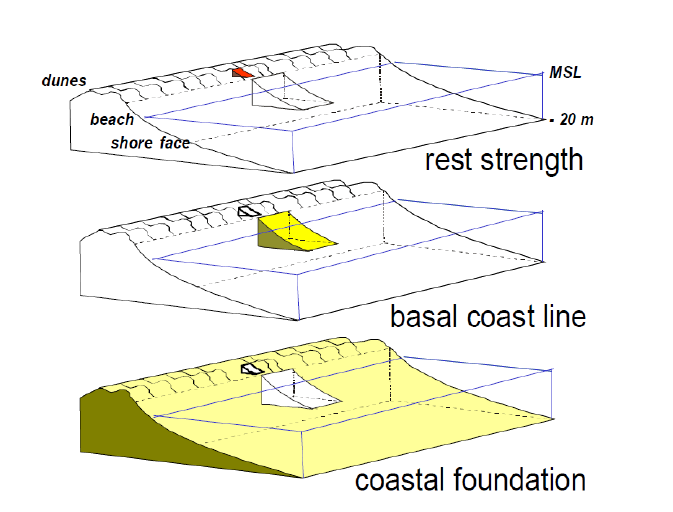
90
Figure 2.2 – Definition sketch of three different scales in coastal management:
Dune rest strength: days – meters
Basal Coast Line: years – kilometres
Coastal Foundation: decades/ centuries – 10’s / 100’s kilometres
from: Mulder et al., 2007.
A.2.7.4 Policy Concepts
The Netherlands coastal policy is based on a sediment management approach.
Besides the strategic objective “to guarantee safety against flooding and to preserve spatial quality
of the coastal zone”, the National Spatial Strategy (2006) depicts a development perspective for the
coastal zone where safeguarding of the dynamic sandy coastal system as carrier of all functions in
the coastal zone, comes first. The priority in this respect is the preservation and development of
resilience and natural dynamics.
In general, the emphasis is on sustainability (translated as the potential to guarantee all coastal
functions in the long term), and on an optimal use of natural processes. The latter is reflected in the
name of the policy “Dynamic Preservation”, and in the three-step strategy for coastal erosion
management (NSS, 2006):
1. Preservation of sand and free transport of sand alongshore and cross-shore of the coast;
2. Sandy measures as much as possible, whenever interference is necessary;
3. Immobilization of sands by hard structures, only in an extreme case.
The policy of the Dutch government is aimed at stimulating a shift of sand mining from land to sea
(Min V&W, 2000). As such, implicitly the North Sea is being indicated as the strategic sediment
reservoir for the Netherlands.
91
Sand mining at sea is only permitted seaward of the 20m depth contour (or seaward of the coastal
foundation as defined by NSS (2006)). The extraction policy for the North Sea is laid down in the
Regional Extraction Plan North Sea (Regionaal Ontgrondingenplan Noordzee RON-MER).
A favourable sediment status of the Dutch coast is defined in terms of preserving a certain
reference sediment volume. This reference volume is defined at different spatial scales related to
different management objectives (see above; Figure 2.1).
At the largest scale the Netherlands coastal policy defines the coast as the coastal foundation: a
littoral coastal cell delimited at the seaward side by the 20 m depth contour and at the landward
side by the landward boundary of the dune massive. Alongshore limits are represented by the
boundaries with Belgium in the South and with Germany in the North. Preserving the sand volume of
the coastal foundation by nourishments, for practical purposes coastal management distinguishes
between three coastal sub-cells: Wadden, Holland and Delta.
At the medium scale, the position of the coastline is derived from the sediment volume around the
Mean Low Water line (MLW). This position is determined yearly, at intervals of 250m alongshore. As
such, the position of the coastline is related to the sediment volume of a medium scale coastal cell
of 250m wide and approximately 1000m long and 8m high (also see Figure 2.1).
A.2.7.5 Further Relevant Developments
An authoritative government commission presented a report with recommendations
on necessary further adaptive measures to climate change for the Netherlands (Delta Commission,
2008). The report underlines the importance of a sediment management approach for the coast,
recommending an increase in the total sand input to the coastal system to a level that should result
in a seaward extension of the coast line of about one kilometre over the next century. The reserving
of the necessary sand mining areas at the North Sea is an important implication of this
recommendation.
Implementation of this recommendation is through the existing water and coastal policy documents;
the Waterplan 2009.
A.2.8 Denmark
A.2.8.1 Overview
The Danish government perceives the Danish planning system (Planning Act) in general to be
adequate to manage the challenges to secure a proper balance between conservation and
development of the coastal zone, supported by existing laws (especially the Coastal Protection Act),
regulations and practices as well as implementing EC Directives and policies. The Danish coastal
zones are regulated by 26 Acts and a number of different systems of regulation (CES).
Danish legislation is permissive. National government only has the duty to judge proposals on their
impact on the environment and, for instance, on sediment processes. The power to undertake
initiatives is given to the counties through legislation (CR-PS).
92
A.2.8.2 Policy Aims and Objectives
The Planning Act ensures that the overall planning synthesises the interests of society with respect
to land use and contributes to protecting the country’s nature and environment, in order to ensure:
sustainable development of society with respect for people’s living conditions and for the
conservation of wildlife and vegetation.
The policy background to the process of strategic planning is enshrined within the Coastal Protection
Act that allows coastal protection where necessary, but promotes natural processes where possible.
In particular:
coastal/flood protection can be allowed only where significant assets are at stake
nature preservation is of high priority especially the maintenance of natural coastal
dynamics
if old coastal/flood protection works are refurbished, the work must be minimal and
redundant protection removed; and
coastal/flood protection works must be technically optimised and fitted into the existing
environment in a discreet way (CR-SP).
Ensuring the adequate performance of flood defences is embedded in a contractual
framework between the Ministry of Transport (MT) and the Danish Coastal Authority (DCA). This
involved the following objectives/actions:
dike inspections (twice per year, embedded in law);
inspection and monitoring of forelands (by the Danish Veterinary and Food
Administration);
coastal retreat and changes in dune width are monitored once per year;
surveying of dike profiles (every 5 years in order to monitor consolidation);
monitoring and evaluation of water levels and wave conditions (every 5 years - part of the
‘contract of result’);
five yearly evaluations of the hydraulic climate are made; and
research and development programmes (focus on risk assessment, requirements for
economic efficiency, damage potential part of the ‘contract of result’).
This process delivers a prioritised programme of actions based on risk. Two time horizons are used,
10 and 25 years into the future (CR-SP).
A.2.8.3 Policy Concepts
The overall planning for ‘sustainable development’ and the high priority for maintenance of natural
coastal dynamics indicate some implementation of a coastal resilience concept.
A.2.8.4 Further Relevant Developments
The Ministry of Environment postponed a debate on a possible national strategy on ICZM until after
2007 when the reform is implemented (EU-ICZM website).

93
Appendix 3.0: Chapter 4 Appendices
94
Appendix 3.1: Summary of Key Datasets Identified
Data Type
Dataset
Description
Source
Year Captured
Spatial
Coverage
Aerial Imagery
OSI Aerial Imagery
Orthoimagery of the coast of Ireland.
OSi
1970s, 1995,
2000, 2005,
2005-2012 &
2017
National
Aerial Imagery
Coastal Aerial
Imagery
Aerial imagery of the coast of Ireland.
Department of
Defence
1950s
National
Aerial Imagery
Oblique Imagery
Survey 2003
Oblique imagery of the coast of Ireland.
OPW
2003
National
Aerial Imagery
Coastal
Photogrammetry
(Drones)
Photogrammetry of selected sites.
GSI and The
Discovery
Programme
Ongoing
Local
Aerial Imagery
Regional Coastal
Surveys
Aerial imagery captured as part of the south to west coast,
west to north coast and east to south coast LiDAR surveys.
OPW
South to west
coast – 2021.
West to north
and east to
south coasts –
ongoing.
National
Aerial Imagery
ICPSS Aerial Imagery
Aerial imagery of the coast of Ireland captured as part of the
Irish Coastal Protection Strategy Study (ICPSS).
OPW
2006
Regional

95
Data Type
Dataset
Description
Source
Year Captured
Spatial
Coverage
Aerial Imagery
Pilot Coastal
Monitoring Survey
Programme
RGB and Near Infrared imagery of the locations included in
the Pilot Coastal Monitoring Survey Programme.
OPW
2020 - present
Local
Bathymetry
Data
INFOMAR
Bathymetry data captured as part of the INFOMAR
programme
GSI and the
Marine
Institute
2000 - present
National
Bathymetry
Data
Pilot Coastal
Monitoring Survey
Programme
Bathymetry data captured at the locations included in the
Pilot Coastal Monitoring Survey Programme.
OPW
2020 - present
Local
Coastal
Features
Tidal Lines
High Water Mark (HWM) and Low Water Mark (LWM).
OSi
-
National
Coastal
Features /
Infrastructure
Eurosion "Erosion
Trends and Coastal
Defence Works"
Layer
This layer features both erosion trends and the existence of
coastal defence works along the coast. 3 codes have been
defined to depict erosion trends (stable, erosion, accretion)
and 2 codes to depict coastal defence works (presence,
absence).
European
Environment
Agency
2016
National
Coastal
Features /
Infrastructure
EMODnet Geology
map on coastal type
This dataset allows users to visualise pan-European coastal
type at different spatial scales. Users can distinguish areas
marked by rocky coasts, (pocket) beaches of sand and
gravel, muddy tidal basins and estuaries, and man-made
coastlines such as harbours and dams.
EMODnet
2021
National
Coastal
Features /
Infrastructure
OPW Flood Defence
Asset Database
Database of flood defences developed through the Coastal
Flood Risk Assessment and Management (CFRAM) Studies.
OPW
n/a
Local
96
Coastal
Features /
Infrastructure
EO Coastal change
ESA
Waterlines and Shorelines derived from Earth Observation
data (Sentinale 2, 2015-2020). Shorelines include HWM,
MSWM, LSWM, and LWM.
GSI
2015 - 2020
Local
Elevation Data
National Digital
Height Model
5m Digital Terrain Model (DTM) derived from
Interferometric Synthetic Aperture Radar (IFSAR) mapping of
the Republic of Ireland.
OPW
2009
National
Elevation Data
Regional Coastal
Surveys
0.25m, 0.5m, 1m, 2m and 5m DTMs and DSMs derived as
part of the south to west coast, west to north coast and east
to south coast LiDAR surveys.
OPW
South to west
coast – 2021.
West to north
and east to
south coasts –
ongoing.
National
Elevation Data
ICPSS Digital
Elevation Models
2m, 5m and 10m DTMs and DSMs obtained for the Irish
Coastal Protection Strategy Study (ICPSS).
OPW
2005 - 2006
Regional
Elevation Data
CFRAM Digital
Elevation Models
2m, 5m and 10m Digital Terrain Models (DTMs) and Digital
Surface Models (DSMs) obtained for the Catchment Flood
Risk Assessment and Management (CFRAM) programme.
OPW
2012
Local
Elevation Data
Cherish Project
Digital Elevation
Models
DTMs and DSMs obtained for the Cherish Project.
GSI and The
Discovery
Programme
2017 - 2020
Local
Elevation Data
Pilot Coastal
Monitoring Survey
Programme
DSMs and DTMs of the locations included in the Pilot Coastal
Monitoring Survey Programme.
OPW
2020 - present
Local
97
Erosion Data
ICPSS 2050 Erosion
Line
Dataset showing the potential future position of the
coastline in the year 2050.
OPW
2010 – 2014
National
Erosion Data
EMODnet Coastal
Behaviour
This dataset allows users to visualise pan-European coastal
behaviour for 2007-2017 at different spatial scales. Users
can distinguish areas of landward migration (erosion or
submergence), stability, and seaward migration (accretion or
emergence). The underlying, downloadable satellite-based
dataset offers additional information on annual values and
uncertainty.
EMODnet
2018
National
Erosion Data
Shoreline-migration
map based on field
measurements and
aerial photography
This dataset allows policy makers, together with national
and regional coastal managers, to determine large-scale
coastal behaviour and identify areas of rapid change. It is
based on field measurements and aerial photography, and
covers time periods up to decades. The map is particularly
valuable for cliffs, which are prevalent along European
coastlines, particularly since state-of-the-art satellite-
monitoring methods aren’t yet suitable for imaging erosion
of non-sandy types of coastline.
EMODnet
2021
National
Erosion Data
Coastal
Erosion/Change from
Space 2019 – 2021
Aim of the project is to develop and demonstrate innovative
approaches for using Earth Observations (EO) products for
the modelling and monitoring of coastal erosion and
accretion in support of developing targeted coastal
management plans
GSI
Due for
publication in
2021
Local
Erosion Data
Erosion Prediction
Lines from Site
Specific Studies
Erosion prediction lines from site specific studies, e.g.
coastal erosion risk management studies.
Local
Authority /
OPW
Varies
Local
98
Flood Data
Catchment Flood
Risk Assessment and
Management
(CFRAM) Studies
Flood Maps
10% AEP, 0.5% AEP and 0.1% AEP coastal flood extent and
depth maps for the present day scenario, MRFS and HEFS at
Areas for Further Assessment (AFA's).
OPW
2018
Local
Flood Data
Catchment Flood
Risk Assessment and
Management
(CFRAM) Studies
Wave Overtopping
Flood Maps
10% AEP, 0.5% AEP and 0.1% AEP wave overtopping flood
extent maps for the present day scenario, MRFS and HEFS at
Areas for Further Assessment (AFA's).
OPW
2018
Local
Flood Data
Coastal Flood Maps
from Site Specific
Studies
Flood extent data from site specific studies, e.g. flood relief
schemes and coastal flood risk management studies.
Local
Authority /
OPW
Varies
Local
Flood Data
National Coastal
Flood Hazard
Mapping 2021 Flood
Maps
50%, 20%, 10%, 5%, 2%, 1%, 0.5% and 0.1% coastal flood
extent and depth maps for the present day scenario, MRFS,
HEFS, H+EFS and H++EFS.
OPW
2021
National
Geological Data
Bedrock Geology
This data represents the latest version of the bedrock
geological dataset for the Rep of Ireland at the 1:100,000
scale digital geological map series.
GSI
2018
National
Geological Data
Quaternary
Sediments
The Quaternary geology of Ireland – Sediments Map is a
representation of the surficial geology of Ireland at a scale of
1 to 50,000.
GSI
2019
National
Geological Data
National Subsoils
Map
The Teagasc Subsoils map classifies the subsoils of Ireland
into 16 themes, using digital stereo photogrammetry
supported by field work.
EPA
2017
National

99
Meteorological
Data
MÉRA Reanalysis
Wind Data
This reanalysis spans the period 1981 to 2015 and includes
surface, near-surface and atmospheric parameters and is the
first of its kind for Ireland.
Met Éireann
1981 - 2015
National
Meteorological
Data
Irish Marine Data
Buoy Observation
Network (IMDBON)
Meteorological parameter datasets from IMDBON provides
vital data for weather forecasts, shipping bulletins, gale and
swell warnings as well as data for general public information
and research. IMDBON data is also used for operational
meteorological forecast models at Met Eireann, Met Office
UK, etc.
Marine
Institute
Ongoing
National
Oceanographic
Data
ECMWF Wave Data
ECMWF operational and re-analysis data.
ECMWF /
Copernicus
Marine Service
-
National
Oceanographic
Data
Sea level daily
gridded data from
satellite altimetry for
the global ocean
from 1993 to present
This data set provides gridded daily global estimates of sea
level anomaly based on satellite altimetry measurements.
Copernicus
1993 – present
National
Oceanographic
Data
Irish Marine Data
Buoy Observation
Network
Wave parameter datasets from IMDBON used for
operational oceanographic forecast models
Marine
Institute
Real time
data. Length
of record
varies, but all
>10yrs
National
Oceanographic
Data
Irish Lights Wave
Data
Data from Irish Lights wave buoys
Irish Lights
Real time
data. Length
of record
varies by buoy
Local
Oceanographic
Data
Irish National Tide
Gauge Network
Marine Institute network of tide gauges
Marine
Institute
Real time
data. Length
n/a
100
of record
varies by
gauge
Oceanographic
Data
OPW Tide Gauge
Data
OPW tide gauge data available at www.waterlevel.ie
OPW
Real time
data. Length
of record
varies by
gauge
n/a
Oceanographic
Data
UK National Tide and
Sea Level Facility
Tide Gauge Data
UK gauges accessible through UK National Tidal and Sea
Level Facility
UK National
Tide and Sea
Level Facility
Real time
data. Length
of record
varies by
gauge
n/a
Oceanographic
Data
Private Sector Tide
Gauges
Gauges owned and operated by the private sector which are
not publicly accessible, e.g. Port Authorities, etc.
Real time
data. Length
of record
varies by
gauge
Varies
n/a
Risk Receptors
Various
Datasets relating to property, utilities, transport
infrastructure, highly vulnerable properties, social
infrastructure, environmental assets cultural heritage assets
and potential pollution sources.
Various
Varies
National
101
Appendix 3.2: Summary of Relevant Research Identified
Theme
Title
Description
Funding
Organisation /
Author
Year
Published
Coastal
erosion
management
The EUROSION
Study
EUROSION is a project commissioned by the General Directorate
Environment of the European Commission, which was won by a consortium
led by the National Institute for Coastal and Marine Management of the
Dutch Ministry of Transport, Public Works and Water Management.
EUROSION is based on the assumption that coastal erosion is a phenomenon
that can never be completely controlled but can be managed in an
economically and ecologically sustainable way. The holistic view favoured by
the consortium integrates:
natural and human-induced causes of erosion (storms, seismic
movements, reduced sediment supply from rivers due to dams,
coastal defences themselves, etc.)
different uses of the coast - including both its terrestrial and marine
parts - and ranging from biodiversity and landscape conservation to
tourism, industry and transport
different levels of management - from local to European and
regional seas
river basin considerations
present concerns and long term perspectives (e.g. climate change)
European
Commission
2004
102
Theme
Title
Description
Funding
Organisation /
Author
Year
Published
Through supporting the Integrated Coastal Zone Management Practitioners
Network and facilitating access to relevant data and information, EUROSION
offers a follow-up to the EU demonstration program on Integrated Coastal
Zone Management - with an emphasis on pilot projects which focused on
erosion management - and is consequently biased towards ICZM strategies.
Coastal
monitoring
Coastal Erosion
from Space
The scope of the ESA Coastal Erosion project is
the development and demonstration of innovative Earth Observation (EO)
products founding the basis for long-term exploitation of earth observation
from satellites by large user communities. These applications aim to detect
and track coastal erosion and accretion to inform coastal management
plans.
GSI
Ongoing
Coastal
monitoring
Copernicus Marine
Service Ocean
State Report, Issue
4
The 4th edition of the Copernicus Marine Service Ocean State Report (OSR
4) published in 2020 provides information on changes and variations in the
ocean over the past decades, with a focus on changes in the marine
environment during the year 2018. It is written by 140 scientific experts
from more than 30 institutions and draws from the marine monitoring
capabilities of the Copernicus Marine Service.
von Schuckmann
et. al.
2020
Coastal
monitoring
Coastal Zones
This final version of the Coastal Zones datasets covering 100% of the extent
for reference years 2012 and 2018 together with the accompanying change
mapping, is now available. Please explore the datasets together with
the nomenclature and mapping guidelines for in-depth information.
Copernicus Land
Monitoring Service
Varies
Coastal
monitoring
European Ground
Motion Service
European Ground Motion Service (EGMS) aims to provide consistent,
regular, standardised, harmonised and reliable information regarding
Copernicus Land
Monitoring Service
Ongoing
103
Theme
Title
Description
Funding
Organisation /
Author
Year
Published
natural and anthropogenic ground motion phenomena over Europe and
across national borders, with millimetre accuracy. EGMS will support
European and national level policies.
Coastal
monitoring
EMODnet Coastal
Behaviour
This dataset allows users to visualise pan-European coastal behaviour for
2007-2017 at different spatial scales. Users can distinguish areas of
landward migration (erosion or submergence), stability, and seaward
migration (accretion or emergence). The underlying, downloadable satellite-
based dataset offers additional information on annual values and
uncertainty.
European Marine
Observation and
Data network
(EMODnet)
Geology
2018
Coastal
monitoring
Shoreline-
migration map
based on field
measurements and
aerial photography
This dataset allows policy makers, together with national and regional
coastal managers, to determine large-scale coastal behaviour and identify
areas of rapid change. It is based on field measurements and aerial
photography, and covers time periods up to decades. The map is particularly
valuable for cliffs, which are prevalent along European coastlines,
particularly since state-of-the-art satellite-monitoring methods aren’t yet
suitable for imaging erosion of non-sandy types of coastline.
European Marine
Observation and
Data network
(EMODnet)
Geology
2021
Morphological
change
Global shoreline
change projections
Projections of global shoreline change in view of climate change considering
the combined effects of ambient change, sea level rise and storm driven
erosion.
European
Commission Joint
Research Centre
2020
Morphological
change
Inventory of
coastal monitoring
methods and
overview of
predictive models
for coastal
Inventory of coastal monitoring methods and overview of predictive models
for coastal evolution.
European
Commission
2007
104
Theme
Title
Description
Funding
Organisation /
Author
Year
Published
evolution
(CONSCIENCE
deliverable D1)
Morphological
change
On the use of
setback lines for
coastal protection
in Europe and the
Mediterranean:
practice, problems
and perspectives
(CONSCIENCE
deliverable D1)
The first part of this report is based on a review of the experiences,
instruments, approaches and tools at the international, European and
national level, in order to answer to the following key questions:
What is a set-back line (SBL)?
Which processes should be taken into consideration for the
definition of (a) SBL(s)?
What are the international experiences in defining a SBL?
Which are the relevant legal instruments and how are SBL typically
used by the member states?
What is the state of the art science and the available technology to
support its definition?
The second part of the report is dedicated to the proposal of common
methodology for the definition of set-back lines at the European level.
European
Commission
2010
Morphological
change
Modelling erosion
of gravel/shingle
beaches and
barriers
(CONSCIENCE
deliverable D13b)
Modelling erosion of gravel/shingle beaches and barriers.
European
Commission
2010
Morphological
change
Modelling of sandy
beach and dune
erosion
Modelling of sandy beach and dune erosion.
European
Commission
2010
105
Theme
Title
Description
Funding
Organisation /
Author
Year
Published
(CONSCIENCE
deliverable D13c)
Morphological
change
Uncertainties in
projections of
sandy beach loss
due to sea level
rise: an analysis at
the European scale
Sea level rise (SLR) will cause shoreline retreat of sandy coasts in the
absence of sand supply mechanisms. These coasts have high touristic and
ecological value and provide protection of valuable infrastructures and
buildings to storm impacts. So far, large-scale assessments of shoreline
retreat use specific datasets or assumptions for the geophysical
representation of the coastal system, without any quantification of the
effect that these choices might have on the assessment. Here SLR driven
potential shoreline retreat and consequent coastal land loss in Europe is
quantified during the twenty-first century using different combinations of
geophysical datasets for (a) the location and spatial extent of sandy beaches
and (b) their nearshore slopes. Using data-based spatially-varying nearshore
slope data, a European averaged SLR driven median shoreline retreat of 97
m (54 m) is projected under RCP 8.5 (RCP 4.5) by year 2100, relative to the
baseline year 2010. This retreat would translate to 2,500 km2 (1,400 km2) of
coastal land loss (in the absence of ambient shoreline changes). A variance-
based global sensitivity analysis indicates that the uncertainty associated
with the choice of geophysical datasets can contribute up to 45% (26%) of
the variance in coastal land loss projections for Europe by 2050 (2100). This
contribution can be as high as that associated with future mitigation
scenarios and SLR projections.
European
Commission Joint
Research Centre
2020
Morphological
change
Global distribution
of nearshore slopes
Nearshore slope, defined as the cross-shore gradient of the subaqueous
profile, is an important input parameter which affects hydrodynamic and
morphological coastal processes. It is used in both local and largescale
coastal investigations. However, due to unavailability of data, most studies,
European
Commission Joint
Research Centre
2019
106
Theme
Title
Description
Funding
Organisation /
Author
Year
Published
with implications
for coastal retreat
especially those that focus on continental or global scales, have historically
adopted a uniform nearshore slope. This simplifying assumption could
however have far-reaching implications for predictions/projections thus
obtained. Here, the first global dataset are presented of nearshore slopes
with a resolution of 1 km at almost 620,000 points along the global
coastline. To this end, coastal profiles were constructed using global topo-
bathymetric datasets. The results show that the nearshore slopes vary
substantially around the world. An assessment of coastline recession driven
by sea level rise (SLR) (for an arbitrary 0.5 m SLR) with a globally uniform
coastal slope of 1 : 100, as carried out in previous studies, and with the
spatially variable coastal slopes computed herein shows that, on average,
the former approach would underestimate coastline recession by about 40
%, albeit with significant spatial variation.
Morphological
change
Review of the
Methodologies
Available for
Coastal Erosion
Hazard Mapping
A review of the methodologies available for mapping the hazard associated
with coastal erosion at national scale and separately at local scale. A key
criteria was that the methodologies to be assessed shall be capable of
estimating the future position of the coastline for the present day and future
sea levels, including allowances for sea level rise. The review includes a
detailed literature review, screening assessment of the methodologies
identified, a detailed review of the potentially suitable methodologies and
recommendations on the methodologies applicable in Ireland.
Office of Public
Works
Ongoing
Sea level rise
High-Resolution
Coupled
Atmosphere-
Ocean-Wave
Regional Climate
This project is aimed at the successful downscaling of both ERA5 and an
ensemble of CMIP6 datasets (e.g. EC-Earth r11i1p1f1) to, ultimately, a
spatial resolution of 4km for Ireland (see Figure 2 for an example) using
coupled model(s) (e.g. COAWST). This research will produce projections of
sea level rise, storm surges and wave climate for a range of timelines and
Irish Centre for
High-End
Computing (ICHEC)
Ongoing
107
Theme
Title
Description
Funding
Organisation /
Author
Year
Published
Projections for
Ireland
future climate scenarios. In particular, return water level extremes (surge
and wave) will be calculated for a number of different return periods; the 1
in 200 year return period levels are typically used in connection with the
design of coastal protection infrastructure.
Sea level rise
Climate Change
2021. The Physical
Science Basis.
Summary for
Policymakers.
This Working Group I contribution to the IPCC’s Sixth Assessment Report
(AR6) SPM provides a high-level summary of the understanding of the
current state of the climate, including how it is changing and the role of
human influence, the state of knowledge about possible climate futures,
climate information relevant to regions and sectors, and limiting human-
induced climate change.
Intergovernmental
Panel on Climate
Change (IPCC)
2021
Sea level rise
Sea level
projections from
the IPCC 6th
Assessment Report
(AR6)
The projections cover the time-period from 2020 to 2150 and are provided
for all future scenarios covered in the AR6. Projections for individual
processes that cause sea level to change are also included in the dataset.
Globally averaged projections, regional projections on a regular global grid,
and local projections at individual tide gauge locations are all provided.
NASA
2021
Sea level rise
Summary for
Policymakers. In:
Climate Change
2013: The Physical
Science Basis.
The Working Group I contribution to the IPCC’s Fifth Assessment Report
(AR5) considers new evidence of climate change based on many
independent scientific analyses from observations of the climate system,
paleoclimate archives, theoretical studies of climate processes and
simulations using climate models. It builds upon the Working Group I
contribution to the IPCC’s Fourth Assessment Report (AR4), and
incorporates subsequent new findings of research. As a component of the
fifth assessment cycle, the IPCC Special Report on Managing the Risks of
Extreme Events and Disasters to Advance Climate Change Adaptation (SREX)
Intergovernmental
Panel on Climate
Change (IPCC)
2019
108
Theme
Title
Description
Funding
Organisation /
Author
Year
Published
is an important basis for information on changing weather and climate
extremes.

109
gov.ie/housing
The Department of
Housing, Local Government and Heritage
