
DEPARTMENT OF THE ARMY
U.S. ARMY CORPS OF ENGINEERS, MOBILE DISTRICT
P.O. BOX 2288
MOBILE, AL 36628-0001
CESAM-RD-M June 6, 2024
PUBLIC NOTICE NO. SAM-2024-00515-GSC
JOINT PUBLIC NOTICE
U.S. ARMY CORPS OF ENGINEERS (USACE)
MISSISSIPPI DEPARTMENT OF ENVIRONMENTAL QUALITY
OFFICE OF POLLUTION CONTROL (MDEQ)
PROPOSED WETLAND FILL FOR CONSTRUCTION OF A CONVENIENCE STORE
AND REFUELING FACILITY, NEW AUGUSTA, PERRY COUNTY, MISSISSIPPI
TO WHOM IT MAY CONCERN: This District has received an application for a
Department of the Army (DA) permit pursuant to Section 404 of the Clean Water Act (33
USC 1344), Please communicate this information to interested parties.
APPLICANT: Racetrac, Inc.
Attention: John Paul Hoover
200 Galleria Parkway SE, Suite 900
Atlanta, GA 30339
LOCATION: Wetlands associated with Milky Creek at the Intersection of U.S Highway
98 and Mississippi State Highway 29; New Augusta; Perry County; Mississippi; Section
30, Township 3 N, Range 10 W: Latitude: 31.199485°N; Longitude: -89.03921°W.
PROPOSED WORK: The applicant proposes to fill 1.89 acres of wetlands and
approximately 32 linear feet of stream for the construction of a convenience store and
refueling facility at the intersection of U.S. Highway 98 and Mississippi Highway 29 in
New Augusta, Perry County, Mississippi. The proposed project includes construction of
a refueling facility consisting of a 3,500 square-foot convenience store, twenty-one (21)
parking spaces, eight (8) gasoline fuel pumps, four (4) diesel fuel pumps, along with
associated infrastructure and stormwater management features. The total project site is
approximately 7.05 acres in size of which 3.08 acres have been identified as wetlands.
Impacts include filling 1.89 acres of forested/shrub wetlands and 32 linear feet of
stream. The applicant proposes to provide in-kind compensatory mitigation through a
mitigation bank.
WATER QUALITY: The Clean Water Act (CWA) Section 401 Certification Rule
(Certification Rule, 40 CFR 121), requires certification for any license or permit that
authorizes an activity that may result in a discharge. The applicant is responsible for
requesting certification and providing required information to the certifying agency. As of
the date of this public notice, the applicant has not submitted a certification request to
the Mississippi Department of Environmental Quality (certifying authority).
CESAM-RD- M June 5, 2024
SAM-2024-00515-GSC Page 2 of 3
HISTORIC PROPERTIES: In accordance with Section 106 of the National Historic
Preservation Act, and Appendix C of 33 CFR 325, the undertaking defined in this notice
is being considered for the potential to affect historic properties. In accordance with
Appendix C of 33 CFR 325, the Corps has determined the permit area consists of entire
undertaking in waters of the United States, which includes the footprint of the proposed
fill areas, and portions of the adjacent property that would be utilized for construction
access and equipment and materials staging. The National Register of Historic Places
will be consulted for properties listed, or eligible for listing, in the National Register,
which are known to exist and would be affected by the proposed work. The Mobile
District is seeking comments regarding the existence, or the potential for existence, of
significant cultural and historic properties within the permit area. At this time, the
USACE, Mobile District has made no determination regarding potential effects of the
project on cultural/historic resources. Further coordination with the State Historic
Preservation Officer and/or federally-recognized American Indian tribes will be
performed as determined to be appropriate.
ENDANGERED SPECIES: Preliminary review of this application and the U.S.
Department of the Interior’s List of Endangered and Threatened Wildlife and Plants
indicate the following federally-listed species are known or expected to occur within the
project area: Red-cockaded Woodpecker (T), Wood Stork (T), Black Pine Snake (T),
Dusky Gopher Frog (E), Gopher Tortoise (T), Yellow-blotched map turtle (T), Louisiana
Quillwort (E), Pearl Darter (T), and Gulf Sturgeon (T). There is no designated critical
habitat within the project action area. At this time, the USACE, Mobile District has made
no determination regarding potential effects of the project on the above-listed species.
Further coordination with the U.S. Fish and Wildlife Service (USFWS) and NMFS will be
performed as determined to be appropriate.
COMMENTS: This public notice is being distributed to all known interested persons in
order to assist in developing facts on which a decision by the U.S. Army Corps of
Engineers can be based. For accuracy and completeness of the record, all data in
support of or in opposition to the proposed work should be submitted in writing setting
forth sufficient detail to furnish a clear understanding of the reasons for support or
opposition.
The decision whether to issue a permit will be based on an evaluation of the probable
impact including cumulative impacts of the proposed activity on the public interest. That
decision will reflect the national concern for both protection and utilization of important
resources. The benefit which reasonably may be expected to accrue from the proposal
must be balanced against its reasonably foreseeable detriments. All factors which may
be relevant to the proposal will be considered including the cumulative effects thereof;
among those are conservation, economics, aesthetics, general environmental concerns,
wetlands, historic properties, fish and wildlife values, flood hazards, floodplain values,
land use, navigation, shoreline erosion and accretion, recreation, water supply and
conservation, water quality, energy needs, safety, food and fiber production, mineral

CESAM-RD- M June 5, 2024
SAM-2024-00515-GSC Page 3 of 3
needs, consideration of property ownership and, in general, the needs and welfare of
the people.
The Corps of Engineers is soliciting comments from the public; Federal, State, and local
agencies and officials; Indian Tribes; and other interested parties in order to consider
and evaluate the impacts of this proposed activity. Any comments received will be
considered by the Corps of Engineers to determine whether to issue, modify, condition
or deny a permit for this proposal. To make this decision, comments are used to assess
impacts on endangered species, historic properties, water quality, general
environmental effects, and the other public interest factors listed above. Comments are
used in the preparation of an Environmental Assessment and/or an Environmental
Impact Statement pursuant to the National Environmental Policy Act. Comments are
also used to determine the need for a public hearing and to determine the overall public
interest of the proposed activity.
Any person may request, in writing, within the comment period specified in this notice,
that a public hearing be held to consider this application. Requests for public hearings
shall state with particularity, the reasons for holding a public hearing.
Evaluation of the probable impacts involving deposits of dredged or fill material into
waters of the United States will include the application of guidelines established by the
Administrator of the U.S. Environmental Protection Agency.
Correspondence concerning this Public Notice should refer to Public Notice Number
SAM-2024-00515-GSC and should be directed to the District Engineer, Mobile District,
Regulatory Division, Mobile, Post Office Box 2288, Mobile, Alabama 36628-0001,
Attention: Greg Christodoulou, or submitted electronically at
Gregory.s.christodoulou@usace.army.mil, 251-387-1066. Copies of all comments
should be furnished to the Mississippi Department of Environmental Quality, Office of
Pollution Control, Post Office Box 2261, Jackson, Mississippi 39225.
All comments should be received no later than 30 days from the date of this
Public Notice.
For additional information about our Regulatory Program, please visit our web site at
www.sam.usace.army.mil/Missions/Regulatory.aspx.
MOBILE DISTRICT
U.S. Army Corps of Engineers
Attachments
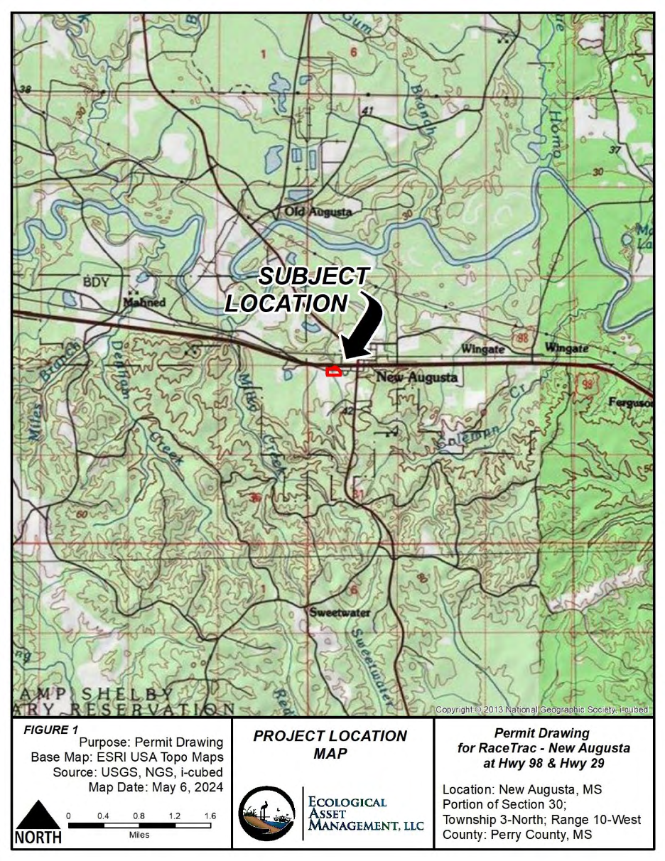
Figure 1. Project Location Map
FIGURE 1
Purpose: Permit Drawing
Base Map: ESRI
USA
Topo
Maps
Source: USGS, NGS, i-cubed
Map Date: May 6, 2024
0
.4
0.8
1.
2 1.6
Miles
PROJECT
LOCATION
MAP
ECOLOGICAL
A SSET
MANA
GEMEN
T,
LLC
Permit Drawing
for Race Trac - New Augusta
at
Hwy
98
& Hwy
29
Location: New Augusta, MS
Portion
of
Section 30;
Township 3-North; Range 10-West
County: Perry County, MS
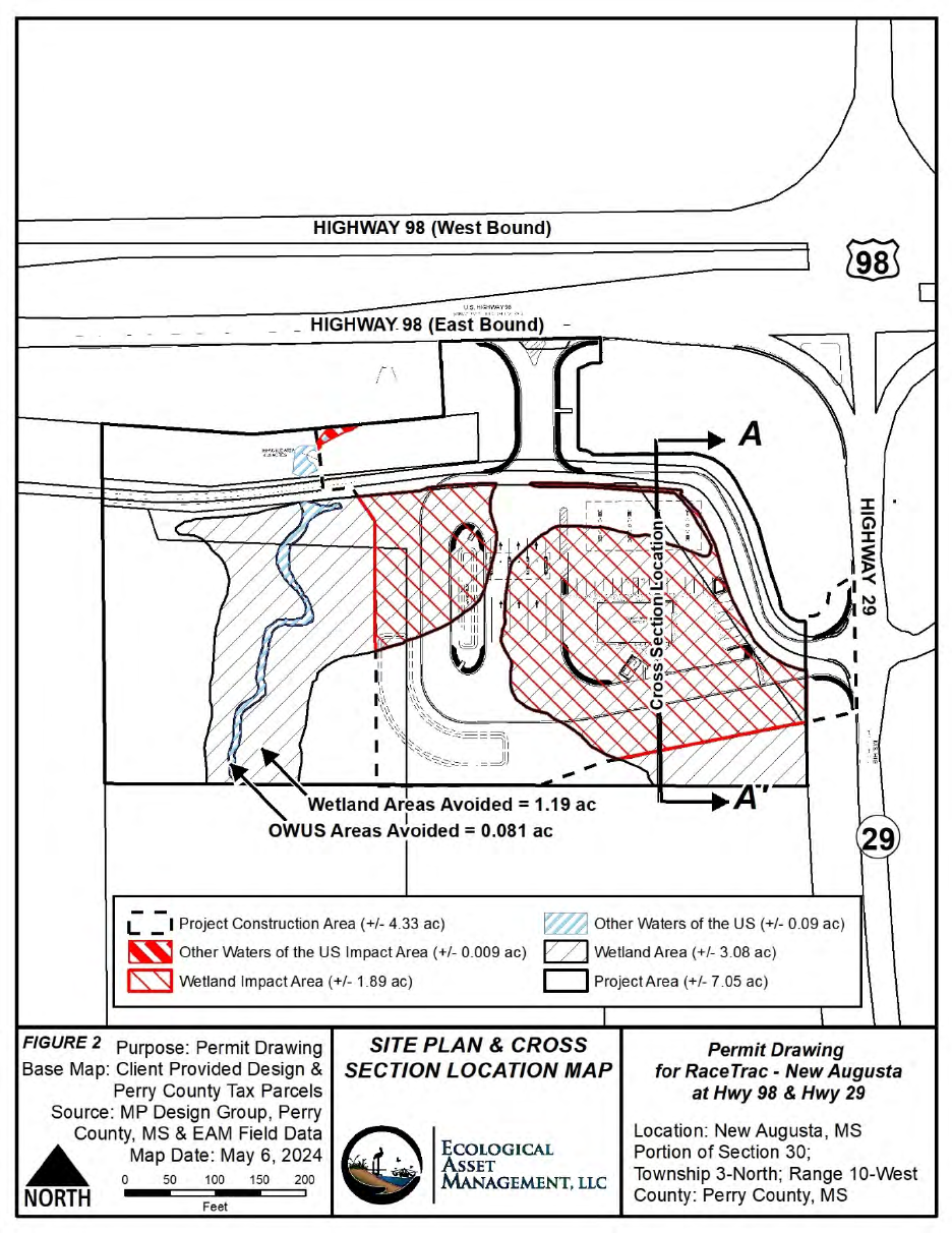
Figure 2. Existing Site Plan & Cross Section Location Map
HIGHWAY 98 (West Bound)
IJ$
1-
0:;;,
_ y _
HIGHWAY 98 (East Bound) -
(\
OWUS Areas AJoided = 0.
081
ac
L _ I Project Const
ru
ction
Area(+
/- 4.33 ac)
~
Other waters of
th
e US Impact
Area(+
/- 0.009 ac)
IS:sJ
Wetland Impact
Area(+
/- 1.89 ac)
~
Other waters
of
t
he
US (+/- 0.09 ac)
EZ]
Wetland Area
(+
/- 3.08 ac)
FIGURE
2 Purpose: Permit Drawing
Base Map: Client Provided Design
&
Perry County
Tax
Parcels
Source: MP Design Group, Perry
County,
MS
& EAM Field Data
..A.
Map Date: May 6, 2024
~
0
so
100 150 200
NORTH
Feet
c::J
Pro
je
ct Area (+/- 7.05 ac)
SITE
PLAN
& CROSS
SECTION LOCATION
MAP
E
CO
LOGICAL
A S
SE
T
MANAG
EMENT,
LLC
Permit Drawing
for
Race Trac -
New
Augusta
at
Hwy 98 & Hwy 29
Location: New Augusta, MS
Portion
of
Section 30;
Township 3-North; Range 10-West
County: Perry County, MS
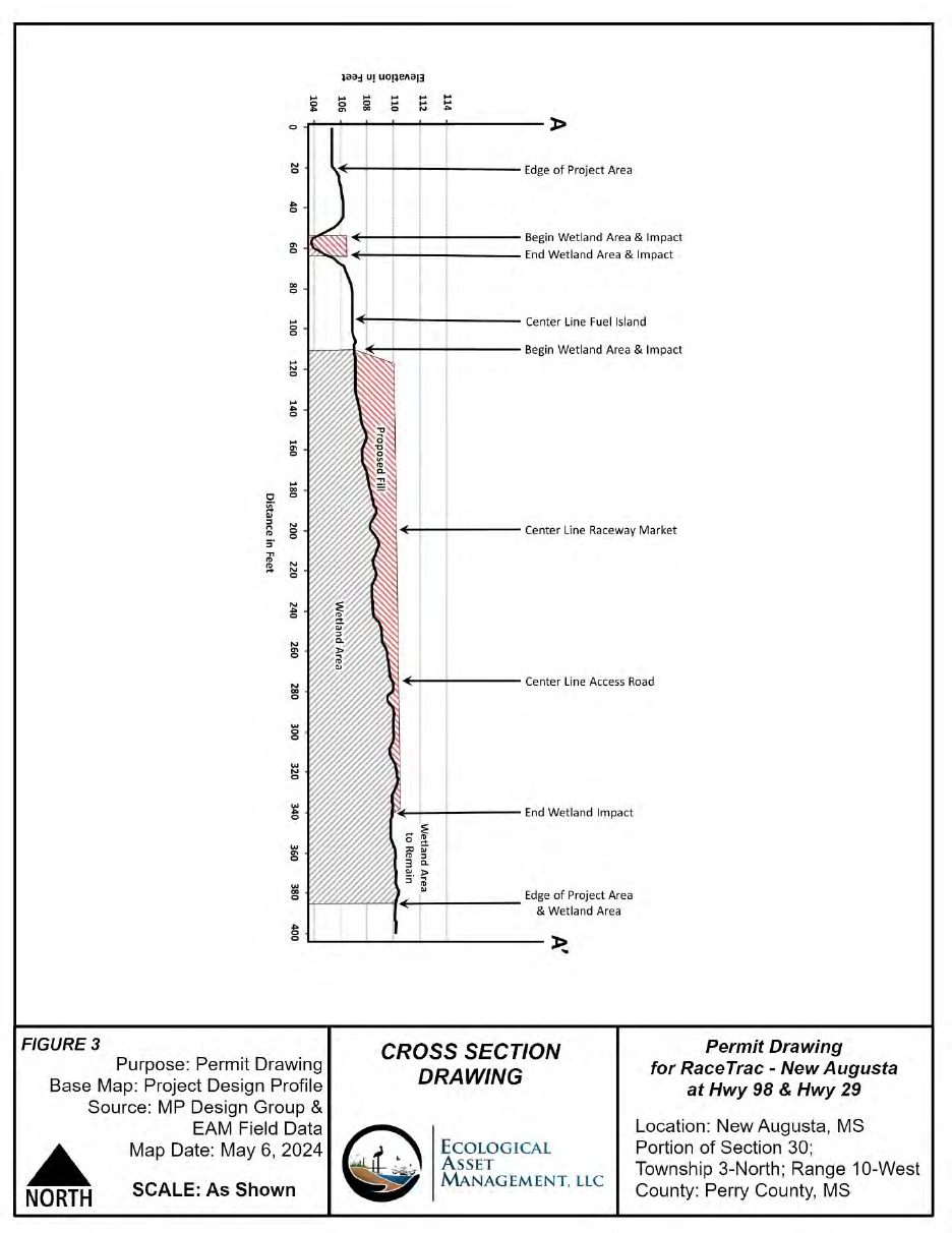
Figure 3. Typical Cross Section Drawing
__
..,....
____________
)>
15
:!l
N
15
FIGURE 3
Pu
rpose: Permit Draw
in
g
Base Map: Project Design Profile
So
ur
ce: MP Design Group &
EAM Field Data
Map Dat
e:
May
6,
2024
..
NORTH
SCALE: As Shown
,+--------
Edge
of Project Area
--------
Be
gin
Wet
l
and
Area & Impact
--------
End
Wetland
Area
& Impact
I+--------
Ce
nter
Line
Fue
l
Is
land
------
Center
Line
Raceway Market
------
C
enter
Line Access Road
~-
-----
En
d Wetland Impact
'+---
-
--
Ed
ge
of
Project Area
& Wetland
Area
CROSS SECTION
DRAWING
ECOLOG
I
CA
L
A SSET
MA
NA
GEMENT
,
LL
C
Permit
Dr
awing
for Race Trac - New Augusta
at
Hwy
98
& Hwy 29
Location: New Augusta, MS
Portion
of
Section 30;
Township 3-N
or
th; Range 10-West
Co
unt
y:
Perry
Co
unt
y,
MS
