Town of Denning
Comprehensive Plan
October 2, 2007

TABLE OF CONTENTS
TOWN OF DENNING -- COMPREHENSIVE PLAN
S E C T I O N T I T L E
P A G E
1.0 EXECUTIVE SUMMARY
…………...……..
1
1.1 How to Use This Plan
………….……… 1
1.2 Local Planning Context
…………………. 4
1.3 Long-Range Planning Vision for Denning
…………………. 5
1.4 Why Plan?
…………………. 6
1.5 The Planning Process
…………………. 7
1.6 Project Organization and Approach
…………………. 8
1.7 The Plans of Adjacent Communities
…………………. 9
2.0 OVERALL COMPREHENSIVE PLAN GOALS
…………...……..
10
3.0 PLAN STRATEGIES
…………...……..
12
3.1 Resources & Environmental Protection
…………………. 13
3.2 Housing & Public Health
…………………. 17
3.3 Land Use & Management
…………………. 19
3.4 Transportation
…………………. 23
3.5 Economic Development
…………………. 27
3.6 Neighborhood & Area Specific Strategies
…………………. 31
3.7 Community Building & Participation
….………………
36
4.0 ACTION PLAN: PROPOSED FIVE TO TEN
YEAR SCHEDULE FOR PLAN IMPLEMENTATION
…………...……..
38
4.1 Organizing for Action
…………………. 38
4.2 Implementation Matrices
…………………. 38
The technical appendix is on file with the Town Clerk as are will be included upon the
Maps referred to as contained in the appendix are.
This project is funded in part by a grant from the New York State Department of State

Town of Denning Comprehensive Plan
- 1 -
1.0 EXECUTIVE SUMMARY
This Town of Denning Comprehensive Plan (hereafter Plan) is the update to the Town of
Denning Master Plan, dated November 13, 2000. The Plan is developed pursuant to Section
272-a of New York State Town Law. The Town’s Planning Board has been charged by the
Town Board with compiling this plan. The Plan is a guide
for future planning and land use.
During the planning process, residents and property owners expressed appreciation for the
natural environment in Denning – this Plan provides a program to maintain a rural ambiance
and manage the growth that does occur so that it complements community character.
The Plan contains goals, objectives, principles, guidelines, policies, standards, and programs
for the immediate and long-range protection, enhancement, growth and development of the
Town of Denning. One major component of this Plan is a recommended program of future
land use regulation. The intent is to guide various potential future development, manage land
use, and guide community resource protection. Provided are a series of modifications to the
zoning, subdivision, special use permit and site plan regulations which prescribe the
appropriate potential use of property, and/or the scale, location and intensity of development
consistent with the long-range planning vision articulated for the Town of Denning. It also
includes policy recommendations intended to advance future economic development.
1.1 How to Use This Plan
This Plan should be consulted frequently and is intended to be a living document. It has a five
to ten year time horizon in terms of taking the actions presented. The Plan may require
amendment from time to time.
Implementation is the measure of a plan’s success. Elected and appointed members of
Denning’s Boards, Commissions and Committees should seek to consider the goals and
recommendations within the Plan and formulate future actions that will advance the
community’s vision consistent with this Plan. Landowners and developers should consult it as
should people interested in the community or starting a business.
The Comprehensive Plan is organized into four main parts:
• Executive Summary -- This section, or division, contains a description of the Plan
organization, the overarching themes facing the community, and describes the
planning process. Most importantly, it lays out the community’s planning vision and
the community’s planning goals.
• Recommended Strategies -- This section contains the overall Plan distilled to its core
measures. It provides a detailed rationale and approach for each individual planning
strategy. The discussion is presented with the various proposed actions grouped

Town of Denning Comprehensive Plan
- 2 -
according to different subjects. Some land use concepts are described for particular
areas of the community. Planning objectives are presented with a narrative on why
topics are particularly important and what these mean to future planning. There are
efforts to show similar cases from other communities. Figure 1, entitled Proposed Zoning,
shows the arrangement of the main zoning alterations proposed for adoption. Overall,
this division describes the planning program and potential focuses in order to help
manage growth, promote design, sustain natural resources, and achieve the desired
community and economic development.
• Action Plan/ Implementation Program – There are matrices of all of the various planning
strategies and policy steps that should be put into practice to achieve desired
outcomes. The Implementation Action Plan (Tables 1 -3) presents each main strategy
and it assigns responsible entities for guiding the particular action. The Implementation
Action Plan also prioritizes these strategies and shows possible sources of outside
assistance.
• Technical Appendices – This volume, bound separately, contains reference information
used in developing the Plan. It includes maps and some notes from public outreach
meetings. An early stage Inventory and Analysis memorandum can be found with a
detailed overview of community and regional conditions and trends broken down by
various main subject elements: Geography; Natural Resources; Demographics and
Housing; Land Use and Zoning; Community Facilities and Services; Transportation;
Open Space and Recreation; Economic Development; and Historic Resources.

Town of Denning Comprehensive Plan
- 3 -
Put FIGURE 1 – here

Town of Denning Comprehensive Plan
- 4 -
1.2 Local Planning Context
Historic development patterns resulted in the concentration of development along the three
river valleys and on adjacent hills. While the commercial thrust of tanning and tourism
influenced an economic peak in the 1800s, the community remains a special and important
place. A century ago, the state land acquisition commenced a prime influence on Town form.
Over the last 30 years housing has been
constructed on Red Hill and at the northern
section of Frost Valley Road. The Frost
Valley YMCA is a major community
institution – its diverse facilities include the
farm and Strauss Center in the East Valley.
YMCA assets also include undeveloped
scenic areas on Red Hill and the
concentrations of historic camps and
administrative buildings in the West Valley.
Interspersed along the Town’s roads are
single family and seasonal residences. Public services are centered in Claryville while Sundown
has a church. Extensive open areas exist all around Town. Over the last decade the New York
City Department of Environmental Protection (DEP) has exerted new influence on natural
areas stewardship and growth.
Within this setting, the major plan recommendations are to:
• Attain sensitive development that helps maintain scenic areas and habitat.
• Provide five acre ‘Rural Residential’ lot sizes and a new ‘Low Density’ zoning district in
the more remote parts of Town.
• Reinforce hamlet development potential by promoting investment and economic
development in the areas that are most suitable and that have services. It is proposed
to reconfigure the hamlets to remove lands that appear unsuitable for development
based on natural resource constraints (no new hamlets are initially proposed).
• Continue proactive planning and management of the road and drainage facilities.
• Achieve diverse housing opportunities.

Town of Denning Comprehensive Plan
- 5 -
1.3 Long-Range Planning Vision for the Town of Denning
A vision statement identifies the broad characteristics and values that the community seeks to
maintain and enhance as it looks toward the future. The vision statement is directional,
establishing a target toward which the community will continue to work. The vision provides
an overall framework for the policies and programs to be set forth in the Plan. Summarizing
the views expressed by the Denning community and its leaders:
Denning is a rural Catskill Mountain town defined by its rugged, magnificent natural areas.
Within Denning the contiguous forests, clean streams and views of the Catskill peaks and
valleys serve as a source of income and inspiration for local residents. These features also
sustain the regional economy. While the lands in Denning support year-round and summer
residents, they have a significant role within a larger area because Denning is among the
communities that serve as the source of New York City’s and other town’s drinking water.
Denning’s small population manages forests and the environment, works in tourism, and
migrates outside the Town for work. Residents know one another and seek to bolster their ties.
As the Town grows slowly within the framework of diverse natural resources and
environmental protection, its landscape will continue unfragmented as high quality habitat and
forested open space. While some change is inevitable, Denning is not a suburban community.
Nor is it a place with all modern conveniences. Accordingly, new housing will be carefully sited
to protect natural resources and enhance established neighborhoods and roads in, or adjacent
to, the hamlets in Claryville and Sundown, and also the settlements at Frost Valley, Red
Hill, Denning and Ladleton. Outside of these places, forestry and other physical development
should occur selectively, with consideration of the capability of the soils, slopes and streams to
support new development.
Small-scale economic development is most appropriate in the hamlets and possibly on the main
roads within the valleys. Through carefully planned and managed growth, Denning will
achieve some basic services, enhance the visitor experience, augment the fiscal base and provide
limited employment for future residents.
Since Denning’s rural character and healthy forest ecosystem are the basis for recreational
tourism and sustainable business, the Town will rely on its green assets as infrastructure.
Thus, there should be limited development of new infrastructure with most investment directed
to the existing roads and neighborhoods. Going forward, the community should promote
development that enhances the scenic beauty of the Town, and is compatible with natural
resource capabilities.
Town of Denning Comprehensive Plan
- 6 -
1.4 Why Plan?
Denning is at a crossroads. To most
people with ties to the community – it
is a very special place. But the very
things that make it special could be lost
without careful stewardship. The
community’s housing stock has been
growing, with seasonal homes being
converted to year-round uses and some
new homes under construction. The
Town, like many Catskill communities,
is a desirable place to visit and more
people are choosing to live in country
environments within the southern tier
of the State. Technological change is also allowing people to loosen their permanent ties to
central cities. Finally, Denning has somewhat convenient access to nearby population centers
in Ulster, Sullivan and Orange Counties, as well as the core New York metropolitan area
further south.
Without a future vision for managing change, development could adversely impact the
environment, public infrastructure, neighborhoods, government finances and the local
economy. For instance, with a large part of the Town currently covered by the three acre
minimum lot size ‘Rural Residential’ zoning district, there is some potential for cookie-cutter,
suburban style development within this very rural place. Existing strengths such as the scenic
landscape, the many open space and recreational assets should be viewed as foundations for
future success well worth protection.
This Plan identifies the community’s unique assets and discusses potential challenges. Using a
balanced approach it examines ways to build on recent accomplishments to ensure a long-
range pattern of growth and development that is beneficial, desirable and sustainable.
This Plan builds on the success of the 2000 plan and the actions that have been undertaken
since it was adopted. It recognizes those achievements and suggests that Denning can
continue to improve its prospects in the future.

Town of Denning Comprehensive Plan
- 7 -
1.5 The Planning Process
It must be understood that the new Plan does not reject or significantly alter the course
prescribed in the 2000 plan. In fact, much of what is contained in this document continues
with familiar themes that remain important within the community. For example, efforts to
protect critical environmental resources are already underway. The goals to bolster hamlets,
protect and manage scenic resources continue to be emphasized. This new Plan updates and
refines these recommendations and provides additional suggestions for achieving smart and
sustainable growth. It also addresses new challenges that emerged in recent years, ensuring
that the community can provide desired economic development and continue to successfully
manage its growth in the future.
It has been over five years since the Town completed its first comprehensive plan. Since there
are no simple solutions to addressing the variety of issues and opportunities that the Town
faces, this Plan provides a set of inter-related planning strategies which are intended to help
Denning retain and enhance its character, manage future growth and provide for sustained
economic development and public well-being. The Action Plan/ Implementation Program
lays out the steps that may be taken to implement the Plan.
Building on the dedication of community leaders and volunteers, Denning has achieved a
number of significant recent accomplishments. A telecommunication ordinance was
developed as were logging laws. There has been continued investment in the public works
equipment and the debt load is quite low. In 2006 the Town joined the State Greenway
program and it witnessed the occupation of the long-awaited addition to Town Hall. In early
2007 the new owner of the former Blue Hill Lodge provided significant reinvestment to
provide a new business use for this prominent Claryville property. There has also been success
constructing upgrades in the solid waste management at the highway garage. The Town’s web
page content is high quality -- the information that may be accessed there is comparable with
that of much larger communities.

Town of Denning Comprehensive Plan
- 8 -
1.6 Project Organization and Approach
This Plan is community-based. It was derived through much input from residents. Since
March 2006 the Planning Board has met every three weeks to review the components as they
were developed, discuss key topics and findings from public outreach. As the process has
progressed, the group reviewed the project design, strategies and recommendations.
As a part of early public outreach, in April 2006, the public was invited to a vision meeting.
More than 25 people met to review community conditions, discuss its strengths, weaknesses,
opportunities and threats. As another part of the planning dialogue, from March to June 2006
the Town’s consultant conducted interviews with elected and appointed public officials, staff,
regional officials, business persons, and non-profit leaders regarding the planning
environment and to gain understanding of community characteristics and trends. The people
interviewed were selected due to specific knowledge of the community, or familiarity with
systems, such as local or regional government, the environment, recreation, economy or
transportation. More than 15 interviews were completed, each approximately an hour.
In June 2006, a second outreach meeting reviewed a vision for the hamlets and
neighborhoods. Furthermore, a message board was established on the Town web page for
comments. In
August 2006, a Planning Board hearing outlined the Plan and the strategies
recommended for its advancement. Based on the feedback received, additional public
meetings were scheduled and there was refinement to the Plan and the planning process.
In late 2006 a detailed community survey was sent to Denning residents and property owners
in order to gauge public opinions regarding the Town’s needs and issues of concern. The
survey provided a way to examine areas of consensus and uncertainty. More than 200 surveys
were returned, representing over 30% of all distributed. The data and findings are available at
Town Hall. In a nutshell, almost 90% of the respondent supported a proactive approach to
managing growth; yet, there is not always clear support for specific steps to direct growth or
promote economic development that is compatible with the protection of the features that
people value.
Public process is essential to developing a long-range plan. As the Plan is implemented, there
will be public outreach to consider adopting modified land use laws.
As a continuing part of the public participation in Denning, there is an open invitation to
submit comments and questions on the Plan. The planning process in Denning has been
commendable in its efforts to involve a broad range of participants, and to incorporate their
concerns. The ideas contained in this document reflect the community’s input.

Town of Denning Comprehensive Plan
- 9 -
1.7 The Plans of Adjacent Communities
Adjacent to the Town’s border, the pattern of land use in the surrounding towns is similar to
that of Denning. A review of the long-range plans for the surrounding Towns shows that the
predominant zoning classifications for the adjacent towns are consistent with this Plan.
The boundaries with Hardenburgh, Shandaken, Olive and Rochester demonstrate similar
patterns of open space (public land), private forest and very low density rural residences. The
zoning in those areas is roughly equivalent, although Rochester allows a slightly higher density.
Wawarsing also demonstrates a slightly higher density of existing development and the zoning
is more permissive than that of the Town of Denning.
Denning’s main settlements at Claryville and Sundown straddle the Neversink boundary.
Travel on the main roads all go through Neversink, as do some routes to Red Hill. The
settlement pattern of houses on smaller lots is also evident in Neversink’s portion of Claryville
and Sundown. In Claryville, however, the existing use mix is more varied than in Neversink as
it boasts a post office, varied types of housing, a church and retail uses.
The Town of Neversink Master Plan
, 1991, is the basis for zoning along a large area to the
south of Denning. Its plan objectives are to protect the health and safety, encourage new
development to locate consistent with the limitations of environmentally sensitive areas,
provide a balanced mix of land uses, and provide commercial development where it is readily
accessible to major roads. In Neversink, Claryville is one of four hamlet focal points for any
commercial, public, and concentrated residential development (the zoning allows up to four
dwelling units per acre). Outside of these hamlets, Neversink’s rural areas are suitable for low
density and low traffic generating residential uses. Neversink’s Rural Conservation Areas are
designated as five acre lot areas for one and two family residences. Sundown is not listed as a
hamlet in Neversink -- it has three acre zoning for one and two family residences. All three of
the rivers flowing south from Denning form part of Neversink’s Floodplain zoning. Notably,
the plan shows intent to plan for and manage views and scenic areas.

Town of Denning Comprehensive Plan
- 10 -
2.0 OVERALL COMPREHENSIVE PLAN GOALS
This section presents the community goals. Denning’s Comprehensive Plan provides
numerous recommendations to help achieve these goals in the form of a variety of planning
strategies. The strategies are identified below in separate sections organized by subject.
Situated beneath the broad vision, the more specific community goals are formal statements
about the tact that Town of Denning hopes to take for the future and over the life of this
Plan. Goals serve as the basis for strategies, policies, and projects that are recommended in
this Plan. Goals provide focus for structuring actions that achieve the overall community
planning vision. The Plan’s goals, or guidelines, establish a frame for decisions regarding land
use, natural resources preservation, community and economic development. The specific
recommendations, such as the adoption or amendment of laws, programs and guidelines,
should be generally consistent with these goals in order to achieve the vision.
In no particular order, Denning’s goals are to:
• Maintain and preserve Denning’s natural beauty and rural character, such as its hillsides
and views
• Help keep land and housing prices affordable for residents
• Manage and improve the form and quality of existing neighborhoods to reinforce and
enhance community character
• Protect water resources
• Accommodate new growth within the traditional community settings and specific
designated areas. Minimize the conversion of undeveloped land in the remote mountain
areas and the outlying areas in favor of careful infill in and adjacent to the valleys and on
Red Hill. This will strengthen the community and its sense of place
• Ensure that development is compatible with natural resources protection by achieving site
development where buildings and access are separated from the most sensitive resources
• Allow for adequate, affordable housing in Denning, including some that meets the needs
of older seniors and those of more modest means
• By working collaboratively with the Town Neversink, plan for coherent growth which
straddles municipal boundaries and provides the desired mix
• Diversify and strengthen the Town fiscal base
• Promote a strong sense of community
• Foster systems of public communication which are informative and accessible in a variety
of forms so that anyone interested has access

Town of Denning Comprehensive Plan
- 11 -
• Recognize that various lifestyles make up the intrinsic character of Denning
• Emphasize maintaining and enhancing existing road and stormwater facilities before
adding new infrastructure
• Encourage and accommodate pedestrian options in hamlets and at large institutional
properties
• Encourage opportunities in technology and economic development that are compatible
with rural development and sustainable resource management
• Support tourism and cooperate with county- and state-level economic development
policies and programs
• Minimize the costs of municipal services, especially costs related to fringe development
• Recognize the limited potential for growth in the hamlets – that which occurs should
appear as small scale and should not be overly intensive
• Support businesses which practice the sustainable utilization of natural resources,
including forestry and farming
• Provide clear and effective land use laws that are specific to the type of land use activity
and its setting. Provide incentives in order to promote and achieve desired outcomes
• Promote public health and well-being by informing residents about how to minimize flood
hazards, and other risks, and describe how they should act in the event of a natural disaster
• Achieve the innovative application of energy conservation and production in order to save
public sector resources and sustain supplies

Town of Denning Comprehensive Plan
- 12 -
3.0 PLAN STRATEGIES
This section of the Plan provides the recommended initiatives. Topics are grouped by themes.
Also known as subject elements, the recommended planning strategies are grouped by topic:
o Natural Resources & Environmental Protection;
o Housing & Public Health;
o Land Use & Management;
o Transportation;
o Economic Development;
o Neighborhood & Area Specific Strategies; and
o Community Building & Participation
A community cannot undertake all of the proposed initiatives simultaneously and with equal
emphasis. Instead there can be assignment of priorities and examination of the actions that are
starting points. If accomplished, these will help build the system of planning and development
articulated within this Plan. Thus, the section ‘Action Plan/Implementation Program’ outlines
the steps that are suggested to implement the various Plan strategies.

Town of Denning Comprehensive Plan
- 13 -
3.1 NATURAL RESOURCES & ENVIRONMENTAL PROTECTION
3.1.1 Identify & Define Key Resources – Cataloging and describing the most
important natural resources within the community will promote awareness of the unique
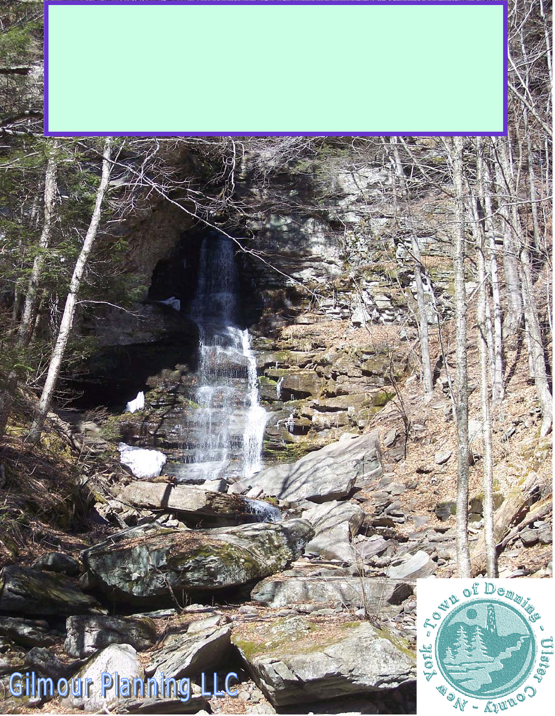
resources within Denning. These include the significant viewsheds, waterfalls, unique
landforms, key riparian corridors, and critical ecological areas including: unregulated wetlands,
unique ecology and special habitats. It will also help promote their protection. A process
whereby special places would be cataloged early in Plan implementation is crucial because the
information generated should guide the economic development initiatives set forth in this
Plan. Therefore, it is essential to generate information for all parts of the Town outside of the
DEC-owned lands so that future development may be promoted which fits-in with and
sustains the essential systems and features that are critical to the community.
A number of other Catskill and Hudson Valley communities have been involved in processes
of generating natural resource and special feature inventories utilizing a variety of approaches
and resources. State, County and non-profit resources and technical assistance should be
available to assist the endeavor. Resources, however, were not available to complete a
comprehensive inventory and evaluation at this time.
In more populated places, such as New Paltz and Gardiner, detailed open space plans have
been produced. Marbletown conducted more basic habitat assessment programs based on
local volunteers who were trained by Hudsonia, the Poughkeepsie-based non-profit.
Hudsonia’s program trains local volunteers to perform habitat assessment using field
observation combined with analysis of satellite imagery and other readily available data.
A process to generate special features maps
should be targeted for completion within a
year. The product could be a large scale
map, or a series of four to six smaller
maps, with annotations and delineations
showing key areas with some
accompanying descriptions. For example,
in some valley basins it might highlight a
key habitat area influenced by steep slopes
and microclimates formed by low
temperatures, high humidity and a low
incidence of direct sun. Then, any
proposed physical development should be
carefully planned so that it does not impact
the most important habitat areas.
Information could reside within Town Hall
with placement in some form on the web.
Town of Denning Comprehensive Plan
- 14 -
Other Plan strategies set-forth below could help identify and define key resources.
For example, a Rondout watershed initiative, just getting underway, is intended to
promote awareness of a regional approach to land management within the basin. If a
local group is formed to help generate an inventory, it could tie into the Rondout
initiative and that program may provide some resources for special features
delineation. Another option is partnering with the Ulster County Environmental
Management Council and non-profit organizations such as the Catskill Center for
Conservation and Development and/or the Frost Valley YMCA in order to take
advantage of their technical capabilities and a tremendous volunteer base.
Alternatively, the required information could be generated in conjunction with
stream corridor planning. Finally, forming a conservation advisory council could
provide a municipal body responsible for developing the local inventory and then
coordinating and consulting with the Town Board and the Planning Board on various
related measures. First, it is critical to generate information so that effective
methods for protection may be developed. The Technical Appendix provides an
Existing Land Use Map, a Hydrography Map and a Slopes Map (respectively Map
Figures 2- 4) which show of the extent of the existing inventories.
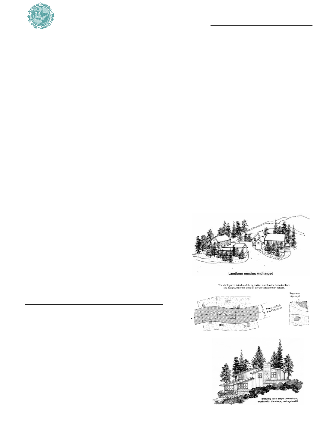
3.1.2 Institute Viewshed (AKA Hillside Protection) Overlay Zoning -- as
another tool to ensure that development blends into the landscape, such as through
building placement, height limits, and the
management of lighting. The Planning Board
should draft a special zoning regulation that
would be triggered when development is
proposed above certain elevations and/or within
an officially delineated view corridor.
Ridgeline protection model ordinances are available
from the Hudson Valley Greenway, including the
Town of Warwick’s Zoning Law. The Shawangunk
Ridge Conservation and Design Guidebook, 1993,
available from the Catskill Center, also shows ways
to protect mountainous areas.
The objective is to
avoid the potential for adverse impacts from
new development on the Catskills open space
environment. Viewshed protection should
minimize the visibility of new physical development
from public roads and hiking trails. Furthermore,
management techniques would require information
within permit submittals that define proposed
grading and landscaping plans in order to assess
building screening. Specifications would also be
required in order to evaluate the potential impacts of

Town of Denning Comprehensive Plan
- 15 -
building on the dark night sky. As noted above, forming a special features inventory
which identifies prominent views would aid this initiative.
3.1.3 Define Density Based On the Incidence of Constraints – in defining the
minimum allowed area of a lot in the Hamlet, no more than one quarter of the area
should constitute severe constraints such as steep slopes (greater than 15 percent),
wetlands, floodplain and wetland buffer. In the Rural zone the figure should be 50
percent and in the Low Density zone this figure should be 75 percent. This will
promote suitable buildable area within lots. Furthermore, there should be definitions
that require the identification of the proposed building envelope with a standard to
show that it is generally free of these constraints. This will prevent impacting and
disturbing these areas except for a very limited extent or in the case of a hardship.
3.1.4 Institute Floodplain Development Zoning – Inappropriate development
within floodplain can elevate the potential for damage to private property and cause
greater flood risk downstream. Clearly, the community is at risk from floods and
should have a flood mitigation plan (as part of a local hazard mitigation plan) -- this
is a prerequisite for receiving hazard mitigation grants. Fortunately, as it stands
now, some similar oversight of the area overlapping floodplain is provided by the
DEP’s regulation of riparian buffers.
A local floodplain management program could also be developed in conjunction with
local emergency management plan development. Also, the National Flood Insurance
Program (NFIP) provides a model system. The Community Rating System within the
NFIP also offers incentives to go beyond the minimum protections. One challenge in
Denning will be allocating resources and assigning an agent responsible for carrying
out regulation and enforcement on a daily basis. Usually, a building inspector serves
as the point person. A process to incorporate floodplain zoning may involve a number
of steps, ensure that stakeholders know about the process, and train staff.
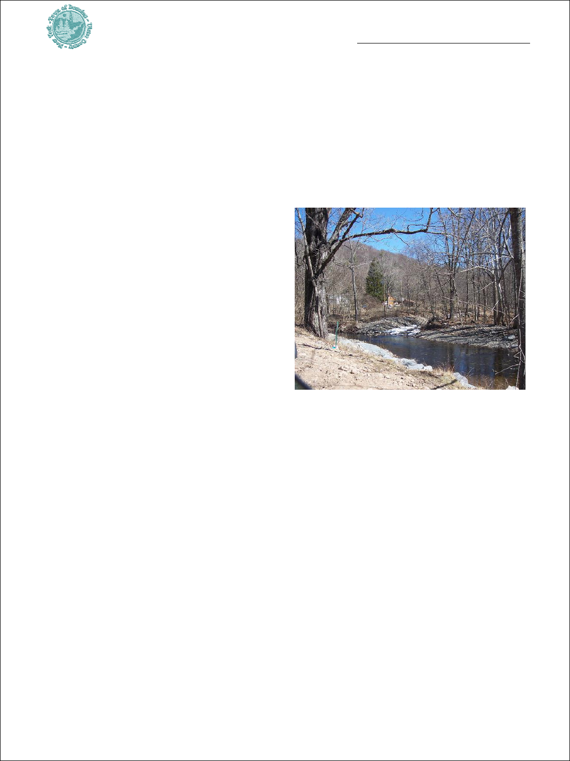
3.1.5 Consider Developing A Local Stream Management Plan – As a means to
protect and effectively manage water quality, aesthetics and habitat within and adjacent to
Denning’s tributaries, the Town could seek to partner with the NYC DEP in formulating a
local, or part-town, tree cutting and stream corridor management plan. This program would
characterize the corridors and could identify areas for restoration and improvement. For
example, there may be opportunities to enhance the riparian edge by the floodplain within
Claryville or Sundown. The process could identify potential sites for State or DEP investment
in stabilization improvements. In addition, it could aid road management and investment in
the river valleys and provide a venue for advancing public access to the rivers for enhanced
recreation.
Along roads that wind through these corridors, the edge is often close to the river, with
significant erosive potential that may result in road damage and stream deterioration. Due to
road layouts and age, these streets require frequent investment for repairs and there is some

Town of Denning Comprehensive Plan
- 16 -
sediment introduced to the waterways. It would be in the Town’s interest to pursue technical
resources to evaluate and promote methods for improving drainage systems. It may also
provide a way to advance capital facilities upgrades, such as by leveraging investment to
rehabilitate bridges and abutments or retaining walls. Another benefit would an increased
potential to provide floodplain management.
The Lake George Park Commission is consulting with the departments of health and
municipalities to plan regulations relative to stream corridor management, including standards
for the location of roads, stream channelization, stream crossings, and timber harvesting.
Denning could monitor this case and communicate with the DEP regarding a desire to
participate in a prototype program within the watershed.
3.1.6 Publicize Frost Valley Y’s Research & Resource Protection Programs –
The YMCA’s staff is trained in the state of the art in topics such as natural resources and
forestry protection. The YMCA should be requested to explore how it can aid the community.
There should also be efforts to build programs and policies that extend to wider applications,
especially so as to protect Town natural resources, enhance the education of local children and
minimize public sector expenditures. The YMCA should be encouraged to further build its
capacity as a local and regional education facility.
3.1.7 Provide Long-Range Monitoring of Lot-Based Septic & Water Systems
When a lot has a well and septic system, or a septic system nearby, there is a potential for the
well to become contaminated. County and State standards for minimum separation which may
not be up to date with the recommendations of health-science are mostly outside local
control. Nonetheless, some problems could arise due to septic system failures. The concern is
valid in all parts of the community due to varying soil capabilities. There do not appear to be
problems locally; however, the community could make the effort to occasionally examine new
information available which can aid understanding of this topic. Based on the findings, there
may be interest in exploring methods to promote well and septic separation or ways to plan
and promote the siting of small shared community on-site wastewater systems, small public
water systems, or a small sewer treatment plant to serve settled areas.
3.1.8 Take Advantage of the Hudson Valley ‘Greenway’ Resources – The
Greenway is an excellent conduit of funds to implement this Plan. The Greenway assists
community planning projects by a single community to address local needs, or by a group
working together to address regional issues. While maintaining the tradition of home rule for
land use decision-making, ‘Greenway Criteria’ provide a vision for:
• Natural and Cultural Resource Protection -- preserve and enhance natural and cultural
resources including open spaces, historic places, scenic areas and scenic roads;
• Public Access – develop a trail system with links to natural and cultural resources; and
• Heritage and Environmental Education -- promote awareness among residents and
visitors about the natural, cultural, scenic and historic resources.

Town of Denning Comprehensive Plan
- 17 -
3.2 HOUSING & PUBLIC HEALTH
3.2.1 Ensure Suitable Areas for Housing Which is Affordable to the
Community/ Local Workforce – the Planning Board expresses a preference for actions
that help keep land and housing prices affordable in Denning. Given that goal, the housing
needs in Denning are somewhat diverse. Various strategies may be used to promote the
maintenance and development of a supply of housing which matches the needs of persons
and families at different stages in the life cycle.
A small jobs base, and a lack of infrastructure or services should influence limits to the
amount of in-migration. In other words, relatively slow growth during the recent real estate
boom is probably evidence that not too many people will choose the lower cost land and/or
housing in Denning and longer commutes, as opposed to settling closer to jobs and/or retail
centers. There are, however, people living here now with modest incomes who will benefit
from housing choices. There appears to be interest in the community as a place to retire.
Finally, demand for seasonal residences will not diminish. Given these circumstances,
promoting a diverse supply of housing, promoting the upkeep of the existing stock, and
ensuring that there are adequate supplies of rental housing, and a range, or mix, of different
size lots and houses should help support different lifestyles and shelter needs.
Promoting adequate land for future development and community housing choices is
compatible with managing environmental quality. This Plan reduces, but retains the one acre
Hamlet zoning district so that there are alternatives to higher cost larger lots. Given the
amount of developable land in the Town, there should be opportunities for community
residents to access land for their housing needs in the foreseeable future. The Planning Board
should continuously monitor the local and regional housing market conditions. It should also
collaborate with the Town Board to provide public outreach and information on the different
ways to promote community housing. If land prices continue to escalate rapidly, the Board
should consider evaluating the proposals for one or more additions to the Hamlets.
Furthermore, the Town should request the DEP to forego formal actions to restrict future
development potential and implement land conservation within the Hamlet zoning district.
A variety of reasonable strategies can help protect and diversify Denning’s housing stock.
Regional non-profits and the USDA have programs which aid the repair and rehabilitation of
housing for moderate income homeowners, older persons and renters. Also, it is necessary to
extend the housing types allowed so that it is feasible to have a range of housing styles and
sizes. The rental housing stock, at 19% of total occupied housing is probably insufficient
given the characteristics of the local population. For instance, the main employer, Frost Valley
YMCA has a sizable year-round workforce, which swells significantly during the summer.
Ulster County Planning estimates workforce increases of approximately 100 to 350 jobs over
the next 20 years. With continued job growth at the YMCA, they should consider strategies to
ensure that their supply of seasonal and permanent housing grows commensurate with the
Town of Denning Comprehensive Plan
- 18 -
workforce. Otherwise, there is likely to be increased pressure in rental market prices as a larger
pool competes for fewer units. Since the workforce and economy fluctuate, having rental
housing stock besides that controlled by the YMCA will allow people to avoid placing very
large amount of their total equity into the purchase of homes.
3.2.2 Develop a Local Hazard Mitigation Plan. This type of plan is intended to
reduce or eliminate the risks to public health and property from known hazards. Hazard
mitigation planning is an important aspect of emergency preparedness and smart, sustainable
growth. In Denning this planning initiative should focus both on improving the protection of
existing settlements and future development. It
is important to continuously consider ways to
reduce hazards that may arise in a natural
disaster or severe storm. A main ingredient of
a hazard mitigation program in Denning
should be building consensus regarding how
the community is vulnerable, based upon
detailed analysis and dialogue among key
stakeholders. Second, there should be
identification of the ways to mitigate potential
risks, with active integration of corrections and
protective measures in the Town planning and
road management programs.
The development of a hazard mitigation plan should be done in conjunction with the
formulation of a local emergency management plan. Furthermore, policies should be
developed in conjunction with the Town of Neversink, Ulster and Sullivan Counties, and the
local Fire Companies. One particular risk to consider is the potential for a particularly large
flood due to freezing and thaws. This initiative should be linked with the local emergency
management communication planning presented further on. New federal law requires a local
hazard mitigation plan in order to qualify for federal funds which underwrite the bulk of
improvement costs.

Town of Denning Comprehensive Plan
- 19 -
3.3 LAND USE & MANAGEMENT
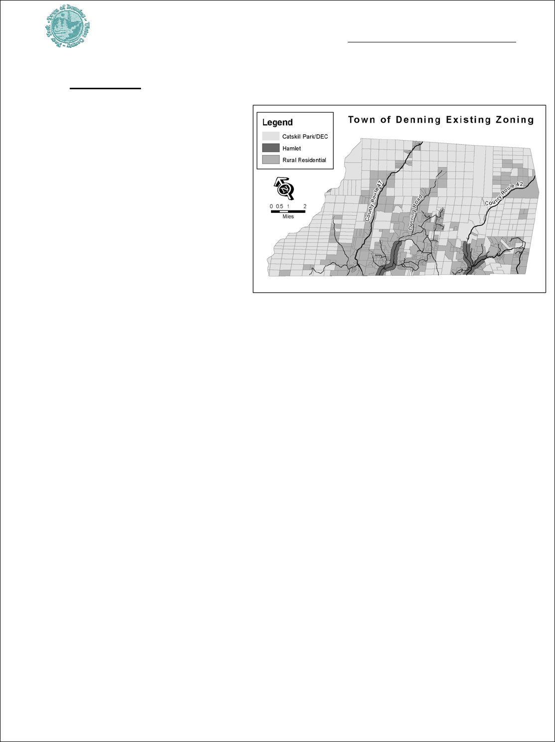
3.3.1 Establish Low Density Zoning (See Proposed Zoning Map Figure 1) –
Denning has two base zoning districts, the three acre ‘Rural Residential’ zone and a much
smaller geographic area within the one acre ‘Hamlet’. Given this zoning, on the nearly 20,000
acres (almost 1/3 of the Town) outside of State lands, there is considerable development
potential. It is roughly estimated that on the order of 900 new lots could be formed under
present zoning. If this development were realized, the character of the Town would change
dramatically. As an alternative, it is strongly advised to manage growth by requiring lower base
densities commensurate with the level of public road service and other factors. The Proposed
Zoning map (Map Figure 1 above) modifies minimum lot size for the most rural, outlying
parts of the Town from three to ten acres though the creation of a ‘Low Density’ zoning
district. Significant future development potential would be retained in Denning under the
overall proposed zoning program (a pattern of one, five and ten acre minimum lot sizes),
including this proposal for larger lots on the periphery of the State lands and built roads.
Many of the existing roads within this new proposed district have limited capacity based on
their age. Unless growth is managed, road deterioration could escalate, inflating the already
high cost of maintaining the infrastructure. For example, research shows that a model density
for maintaining a high quality gravel road’s capacity is nearly seven acres per dwelling unit. On
poorer quality gravel roads, meaning ones which are narrower, have inadequate drainage,
constrained road widths and problematic alignments, even lower densities would be needed to
avoid road wear and deterioration due to growth. Similarly, since most of the outlying Town
roads that are paved are steep, and not up to contemporary standards, a similar rationale
would point to managing the future development in order to sustain the infrastructure.
These areas proposed for larger lot zoning have prevalent steep slopes and high incidences of
forest coverage. They also demonstrate very low densities of existing land use. Finally, while
introducing larger lot zoning closer to urbanized areas may contribute to regional sprawl, in
Denning, the action to direct growth back towards the much smaller, reconfigured Hamlets
and the remainder proposed five acre ‘Rural Residential’ zoning should promote the retention
of high quality forested areas while still allowing for future growth. Numerous communities
have large lot zoning. Neversink has had five acre zoning for over a decade, as do towns
within the Adirondack Park, a region comparable to the Catskills.
This Plan recognizes that new surveying techniques may have altered lot sizes slightly from
that which owners originally thought they had. In ascertaining whether a variance will be
considered in subdividing property, the oldest deed available in the name of the current
petitioners should be used to determine eligibility in granting permission to subdivide.
There is a reasonable basis for going with lower zoning densities. As already discussed, there
should be monitoring for increased rates of road deterioration. Decline is a basis for further
Town of Denning Comprehensive Plan
- 20 -
action. Moreover, with the use of incentive zoning, such as allowing somewhat higher
densities in return for open space and recreation, affordable housing, the construction of ultra
energy efficient housing, or other dedications, dropping the base density further, such as to 12
to twenty acres, can allow additional density increments to be recovered as incentive.
3.3.2 Promote Coordinated Land Use on Estates & Non-Profit Lands - Given
their large land holdings the Frost Valley YMCA should be directed to prepare a Generic
Environmental Impact Statement prior to it pursuing any major development programs. A
specific proposal to develop a major facility, such as structures covering more than 10,000
square feet of floor area, and any subdivision involving four or more lots should cause the
formulation of an Environmental Impact Statement (EIS). This approach is recommended on
all large estates and camps, such as when these thresholds are exceeded.
3.3.3 Clarify/ Refine Use Schedule, Standards & Site Plan Approval Process
– As discussed in other places in this Plan, there should be enhanced standards, review criteria
and conditions of approval for many types of development.
Currently, some uses are either allowed by-right or have very
basic regulation. Modifying the ‘Use Schedule’ will enhance
and clarify the mix of allowable uses. For example, there
should be guidelines for developing a bed and breakfast and
the use should require site plan approval. Similarly, standards
should be provided for a veterinary clinic. Rather than
manage all uses uniformly, it is also advantageous to provide
larger lot and/or special use standards for some potentially
heavier or noisome uses like Gasoline stations or places of
automobile repair.
3.3.4 Clarify the Subdivision Plan Review Process & Standards – Subdivision
review is the process whereby the Planning Board reviews a proposed division of land for
development, such as dividing a parcel into lots and providing new road(s) to the site.
Subdivision regulations include standards for defining natural features and assessing the
capabilities of the land proposed for development, the layout of lots and utilities.
Problematically, Denning’s subdivision laws are over 30 years old. These laws need to be
brought up to date, clarified and re-codified consistent with this Plan, current New York State
Town Law and General Municipal Law, as well as Ulster County policies.
While enhancing the subdivision review procedure was a main recommendation of the 2000
Master Plan, there has been no progress with this objective. It is possible to revise regulations
to protect natural resources while providing an understandable procedure for land owners.
State enabling laws concerning subdivision review include §276 and §277 of Town Law.
Critical to establishing an effective land-use oversight system are strong standards, precise
evaluation criteria, clear guidance and flexible, powerful regulations that are unambiguous to

Town of Denning Comprehensive Plan
- 21 -
the public, applicants and interested parties. By defining the desired types and forms of
development, allowable exceptions and the criteria by which to evaluate waivers within
bolstered subdivision regulations, it should be possible to process applications which do not
require waivers without much delay.
In addition, in order to promote efficient reviews, a stronger emphasis should be placed on
the process of encouraging early stage consultations. Applicants for major subdivisions should
be required to provide a basic area-level analysis. Submittal of secondary source information
could be delineated on an aerial photograph, showing features such as floodplains, other
wetlands, and riparian corridors, soils, slopes and other key features. This will build familiarity
with a site and its surroundings and provide a good lead into SEQRA and the rest of the
permitting process.
Clarifying the process and including site-specific considerations will take time and dedicated
effort. The revision process should include the following steps:
• Clarify definitions.
¾ ‘Resubdivision’ should be clarified. Members of the Planning Board express
concern that under current procedure, loopholes provide a potential for repetitive
actions to create additional lots from one main tract which was previously altered.
Rather, after the first re-subdivision, any additional parcel proposed should trigger
full subdivision review so there is not a routine cleaving of lots off of the same site
without more oversight.
¾ Numerous other clarification are also recommended, including: standards for cul-
de-sac (dead-end street) and their maximum length; vested rights; specific meaning
for condominium development and division by deed; and the meaning of standards
for open space development, also known as cluster development.
• Modify and incorporate the enforcement ordinance into the subdivision law – An existing ordinance
pertaining to violations of the subdivision regulations should be incorporated within
the main law and should be upgraded consistent with it. A subsequent re-codification
of all of the subdivision regulations should provide clarity.
• Provide Design Standards & Graphic Depictions of the Desired Forms of Development. Pictures
and diagrams that describe options and approaches for new road layouts, driveways,
curb cuts and appurtenant drainage systems should recognize the unique features
within the Town and define the preferred approach for construction. Promoting
consideration of the desired development form in accordance with the natural resource
capabilities will ensure that new infrastructure will hold up over time and perform
optimally under extreme weather.
• Develop subdivision and local law standards for the design, construction and
performance for new public and private roads. Review the standard for ‘frontage’ and
Town of Denning Comprehensive Plan
- 22 -
‘suitably improved road’ in order to clarify what constitutes a suitable means of access
and acceptable frontage.
3.3.5 Provide Basic Design Guidelines – Design
guidelines are a tool for informing applicants, agents and
the permitting body of desirable building and site planning
before plans are submitted. Guidelines can inspire inventive
ways to blend projects, building additions and site access
with the neighborhood and natural features. The Greenway
Principles for Dutchess County show approaches to various
elements of site development. Organized by topic, such as
landscaping, parking, lighting, signage, these standards of
best practices provide examples of quality site and building
development. Since a picture can be worth many words,
situating them within Town codes will promote a common
language regarding site planning preferences. It will also
show how to integrate the parts of a development into a
cohesive whole. Design guidelines can define ways to
achieve growth while maintaining the rural character and
appealing visual quality of the hamlets and adjacent areas.
3.3.6 Achieve Open Space Design -- One reason for building a better early stage
evaluation process is that it should lead to an efficient process of achieving quality
development. As a key means to protect special site features, the Planning Board, should
immediately work towards the adoption of Open Space Design permitting process. This
technique is gaining increased attention throughout the region. The process emphasizes the
pre-application stage of a development proposal. It identifies special features of a site and
promotes a layout of the site-level
development so as to maximize the
retention those special features. In a
rural community such as Denning,
open space design should not be
construed as requiring residential
minimum lot sizes of less than 1.5 acres
outside of hamlets. Rather, it should
provide flexibility in the arrangement of
lots, and allow somewhat smaller lot
sizes than the minimum provided for
within the underlying zoning district.

Town of Denning Comprehensive Plan
- 23 -
3.4 TRANSPORTATION
3.4.1 Develop a Capital Improvement Plan -- A capital improvement plan (CIP) is a
long-range plan that is updated annually. This economic development tool identifies needed
purchases, construction, major repairs, or reconstruction of facilities such as roads, bridges,
utility systems and buildings that have a long useful life. Containing a five to seven year time
horizon, in Denning, the document would be focused on roads, drainage and highway
equipment needs. It should also identify other public investments, such as in buildings, parks
and land acquisition, and possibly computers or needed planning studies. One advantage
would be the link it provides to comprehensive plan implementation. The Town Board would
lead a process of capital planning. Annual consideration of the capital budget for the next year
would constitute part of the process of adopting an overall operating budget. Pursuing a CIP
process fosters awareness of long-range planning needs, providing perspective to elected
officials and the public. It helps coordination with external agencies, and influences quality
development within the community. Importantly, it promotes both avoidance of costly
mistakes and the cautious use of tax dollars by establishing a focus on this segment of
planning and expenditure as it relates to community needs and capabilities.
In Denning, capital planning currently occurs within annual budgeting. The Town does a
good job budgeting funds annually for road management and improvements, but the
extensive public road network requires constant attention and growth can produce stress.
Denning, however, does not formally evaluate or forecast upcoming needs over the long term.
The school budgeting and planning process is separate from Town administration, and the
volunteer fire departments receive revenues from a separate taxing structure. As part of a
program of managing growth, the Town Board should request participation from the fire
departments and the school. The latter objective would require coordination with the School
Board and the other municipalities in the District. By showing the preferred infrastructure
upgrades within a CIP, competing facility needs could be listed over longer horizons, which
could aid forecasting and budgeting for major purchases so that the different investment
needs may be evaluated, compared and synchronized.
3.4.2 Achieve Enhanced Road Planning & Management -- In order to promote
enhanced capabilities for road management, the community should consider using software,
either through a local purchase or in
collaboration with adjacent municipalities and
counties. Specifically, instituting a pavement
management system would allow better use of
facilities data to guide decisions. A challenge is
allocating resources to collect data and ensuring
that use of the system does not become a low
Town of Denning Comprehensive Plan
- 24 -
priority over time. An advantage is that there already is an inventory of drainage structures
within the County road system which can be used. This database could be augmented over
time and it could aid emergency management planning.
The advantage of a pavement management system is that it helps define cost-effective
investment in roads. For example, by identifying roads that are on the cusp, but not
deteriorated to the point of requiring major reconstruction, it is possible to define the highest
returns on the investment of public funds. It identifies the potential to institute repairs and
stabilization that are far less expensive than when the road is so degraded that it requires full
rebuilding. This strategy jibes with other recommended initiatives to perform long-range
capital planning and adopt an official map. It could play a role in understanding the potential
impact of specific development proposals.
Finally, a major related policy that should be faced in Denning surrounds a series of decisions
whether to invest in dirt roads and provide pavement. There clearly is a role for dirt roads, but
if it is an imperative to allow more development on some of these roads, then paving should
be considered. An example of a road that likely will achieve a far higher level of use in the
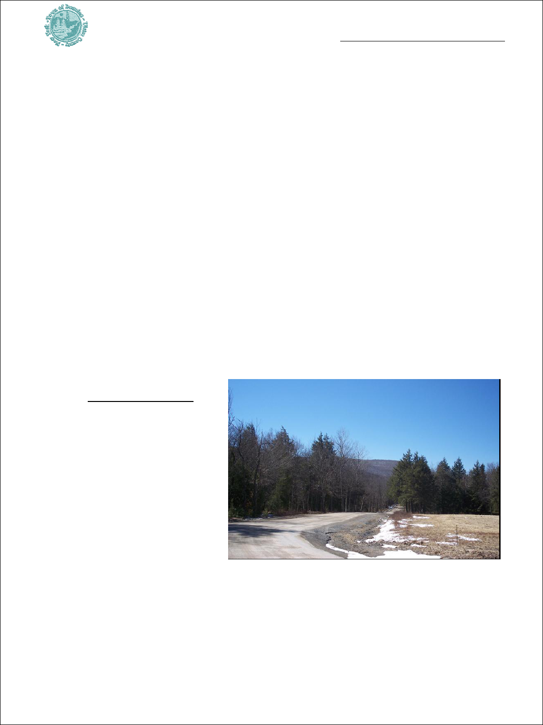
future and could deteriorate if not managed is Red Hill Road. The Town should seek external
technical assistance, from the County, and set aside funds to study of road performance.
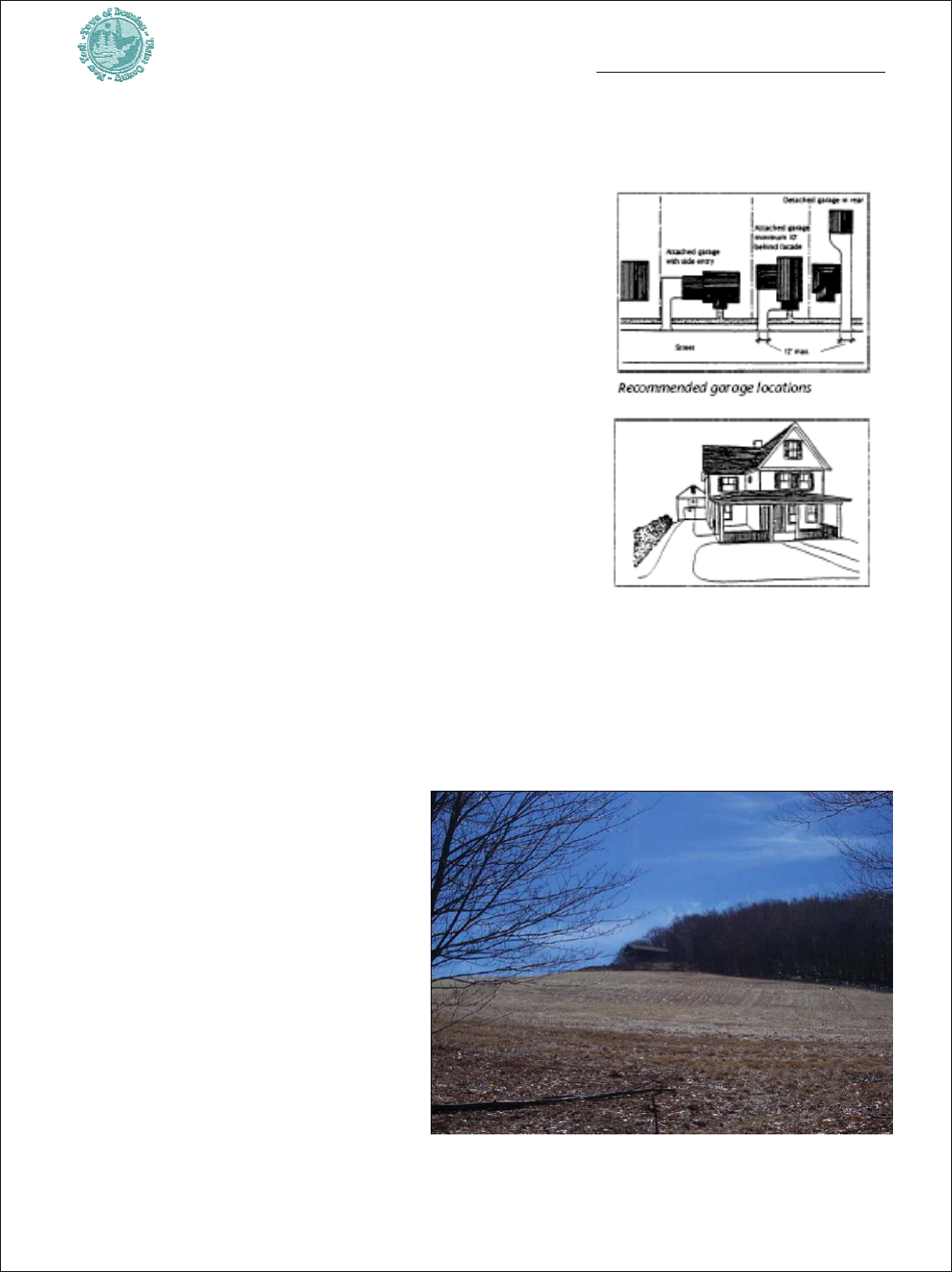
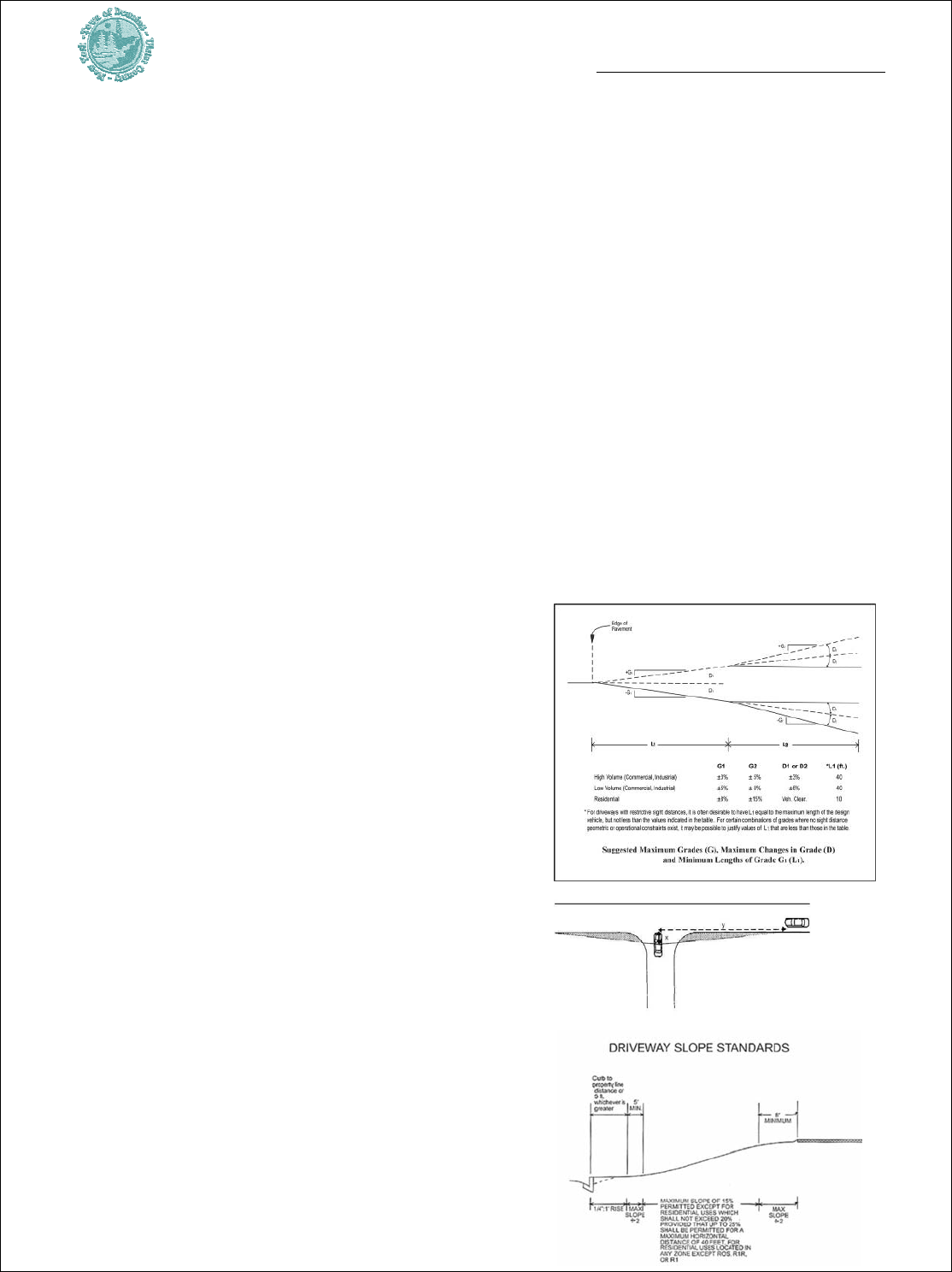
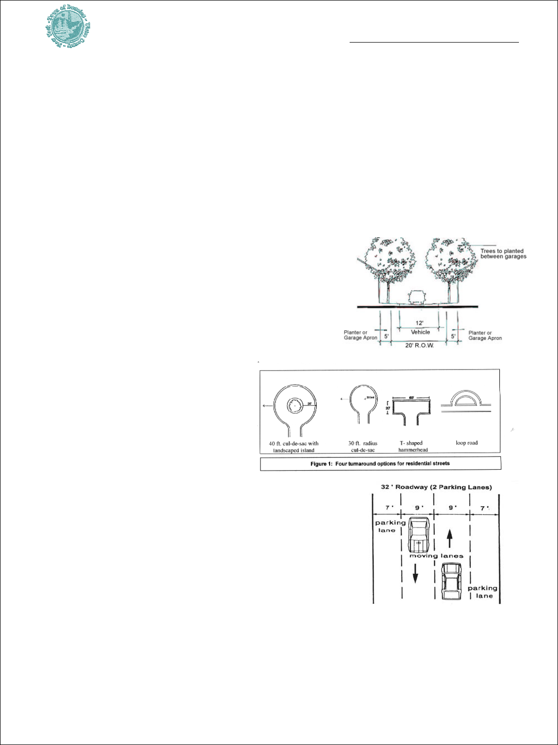
3.4.3 Adopt Driveway & Common Driveway
Standards – Clear standards for the development
of individual driveways should be adopted to ensure
they meet public safety and natural resource
protection objectives. For example, there should be
minimum and maximum widths and limits to the
maximum length and grades of new driveways. There
should be pullovers at adequate intervals, clear
identification of address numbers at all driveway
intersections, submission of basic construction
specifications, with consideration of the stormwater
impacts from driveways on public roads, and
management of driveway spacing and design,
especially on main thoroughfares. The Town of
Gardiner recently adopted a local law managing
driveway layouts. Recommended components are:
• Roads and driveways shall follow the natural
topography to the greatest extent possible to
minimize the cutting and grading of critical
slopes. As a means to minimize the potential
for excessive disturbance and stormwater

Town of Denning Comprehensive Plan
- 25 -
impacts due to driveway design or construction, driveways should have maximum
slopes less than 10 percent. Plan submissions shall provide profiles and typical cross-
sections of any proposed driveway.
• The Town Highway Superintendent should be required to review all driveway designs
adjoining Town roads to insure that stormwater flow is managed in relation to the
public way and the roadside drainage system has
adequate capacity, and to ensure adequate sight
distances.
• The respective Fire Chief should have a role reviewing
the proposed driveway to ensure the design provides for
adequate emergency response.
• Achieve 500 foot separation between driveways on County roads and allow 200'
distance between driveway cuts on local and private roads.
• Anyone needing a driveway on a County road should be required to provide a copy of
the County Highway Department approval to the Town to ensure that driveway
proposals were reviewed to ensure that there is adequate turn around space within a
property, and the layouts are optimized to prevent conflict with traffic on the road.
Long and wide driveways may be necessary in some cases to provide access to a steep slope
lot. In those instances, there should be exploration of alternative access in order to improve
design options, including the feasibility to join into an existing adjacent driveway. New, shared
driveways may be explored as an option to reduce impacts. Similarly, shared driveways may be
promoted to manage traffic on main thoroughfares. In low density areas and hamlets, this
could provide an alternative to requiring the development of new public and private roads
that serve very small numbers of homes, and which could be difficult to maintain or provide
excessive impervious (non-porous) paved area.
The Town could provide a process to permit common driveways when it is shown that the
design will ensure safe and adequate access, compliance with standards for driveway design,
emergency access, and routine maintenance. Clear deeds and covenants would ensure rights
for all involved parties to use the driveway. Permanent maintenance covenants and
requirements would be executed by the parties that own and have access to the driveway.
3.4.4 Modify the Local Logging Law -- There is a current law which provides local
oversight of logging. A principle of this Plan is that the Town supports the right to practice
forestry. Forestry, based in the science of silviculture, is the process of controlling the
establishment, composition, and growth of renewable forest resources, and harvesting
(logging) is an important and necessary part of this process. A concern articulated in the
public process to formulate this Plan is that trucks and equipment aiding lumbering have been
known to damage Town roads. The law should be updated to require a performance bond or
guarantee placed on file with the Town to recover the cost of possible damage an operation
Town of Denning Comprehensive Plan
- 26 -
may do to Town roads. Where logging trucks enter Town roads from logging jobs, the
driveway entrances and access locations must be approved and constructed to prevent traffic
hazards or damage to Town property. If additional limits/restrictions are established to
manage the impact from logging truck operations on Town roads (seasonally, condition
based, or otherwise) the rules should be equitable. For one, fees imposed should be
proportional to the number of heavy truck trips associated with the logging application,
compared with the rate of all heavy truck trips. Clearly the Highway Superintendent will have
a main role in updating and implementing this procedure. There should also be requirements
that logging operations conform to New York State and Watershed Agricultural Council Best
Management Practices (BMPs) in all timber harvesting operation within the Town.
3.4.5 Clarify Road Policies – the subdivision
regulations and zoning should be clarified regarding the
minimum frontage requirements and road improvement
standards (public and private roads). This would define
suitable frontage and would explain how to apply to
make a private road public. As discussed above, there is
also a need for road construction standards and guidance
as to when it may be possible to build to a reduced
standard. Land use incentives should be examined as a
means to achieving desired
maintenance and development on the
existing public road network.

Town of Denning Comprehensive Plan
- 27 -
3.5 Economic Development
3.5.1 Consider a Right to Forest & Farm Law – Denning’s economy depends on
natural resources-based industry, particularly forestry. As the community grows there may be
opposition to harvesting, based on perceptions that these activities provide noise or traffic. As
part of a Planning Board program to visit the performance standards for forestry, the Town
Board should adopt a resolution reaffirming the right for foresters to operate, provided they
comply with local regulations. Done in conjunction with the right to farm law, this would help
protect the future of forestry operations.
3.5.2 Encourage Community Supported Agriculture (CSA) – local agriculture can
enhance food security and community character through the use of prime fields and open
space. There are many CSAs in the region, including the Phillies Bridge Farm Project. State
funds could help a private individual or a non-profit obtain a farm site if one can be identified.
3.5.3 Support Parks Programming & Playground
Development -- The Town Board should explore restoration of
Denning’s participation on the Neversink Recreation Commission
to promote options and healthy lifestyles for children. As part of
this process, the Town should consider potential recreation needs
of the community and monitor demand. Based on the findings,
the Town might explore the potential to provide a small passive park, and a multi-purpose ball
field somewhere within the Town, and possibly a small playground in Claryville.
3.5.4 High Performance Building – The Town should require
energy efficient construction in public buildings as a way to avoid
high operating costs do to increased energy prices. The Town should
also strongly encourage the School District to reduce its energy
consumption as a way to promote savings in operations and ultimately
minimize expenditures, especially outside of the core mission of
education. The latter objective could also aid education regarding new
sustainable technologies. Finally, in adopting an incentive zoning system,
there should be rewards, such as an allowance for a higher zoning density, for
constructing buildings utilizing energy saving techniques, for the installation
of significant energy saving measures (high performance buildings), and using
high proportions of local materials in construction.
3.5.5 Promote Better Phone & Cable Service – Many residents would like better cell
phone service, but many also prefer that new infrastructure is compatible with scenic

Town of Denning Comprehensive Plan
- 28 -
resources to the extent practicable, such as though the use of repeaters or other technology. It
should also be verified that when a new service is proposed, it is because of gaps in coverage
(meaning that there is not already service in an area), that there are not collocation
opportunities, or that the request comes simply because a specific carrier is not operating its
own site in the local market. The Town Board should outreach to telecommunication and
cable utilities in striving to achieve better telecommunications and television services,
including moderate to high speed internet access. There should be exploration of how
Claryville or Sundown might benefit if new infrastructure is planned for Frost Valley.
3.5.6 Furniture Crafting Guild – In public meetings when discussion turns to Denning’s
economic future, a frequent topic of discussion is how to achieve a high quality furniture
crafting business, or cooperative, as a way to add value to local timber harvests, create
community jobs and diversify the economic base. There is a furniture and arts guild in New
York City. In Tennessee, the Cumberland Furniture Guild is an excellent example and in
Florida and Georgia there are also comparable initiatives.
The Catskill Watershed Corporation (CWC) studied potential financing to promote
economic development within the DEP watershed. While some programs were
established, currently most programs are unfunded because initial funding was
expended. Accordingly, the Town Board could advocate for new funding. It should
monitor other potential to apply for technical assistance, possibly pursuing a Greenway
grant if this is a high economic development priority.
3.5.7 Water Company or Cooperative – Consider a small-scale water-based industry,
such as a bulk export operation or consumer-focused operation, which would be based on a
sustainable yield of high quality ground water. The idea would be to provide a value-added
service to a local resource. A similar case of a water withdrawal operation occurred recently in
Shandaken. If organized as a cooperative, if profits are achieved, these could be directed to
serve as school tax relief or be invested in other economic development initiatives.
3.5.8 Join with Frost Valley YMCA in Economic Development Programming -
- Partnering with Frost Valley YMCA to plan for and achieve new and expanded service
offerings that are compatible with the Y’s non-profit mission and which aid Denning’s
economic development is a win-win approach. For example, if there were an opportunity to
use the YMCA farm for community-supported agriculture, it could aid local food security.
Similarly, developing a trades-based school dealing with topics such as furniture making,
forestry, or ecology would be a good match with the laboratory that Denning could provide.
3.5.9 Explore & Promote Distributed Generation Potential – The Town needs
land use management standards for newer energy technologies. There are no zoning standards
now, which may put the community at risk. It should add windmills, photovoltaic, and small
hydroelectric facilities as special permit uses and plan for a compatible installation. As threats
Town of Denning Comprehensive Plan
- 29 -
associated with climate change elevate, there is more support for alternative energy.
Furthermore, more technologies are evolving to new levels of sophistication with lower costs
per unit of energy. Distributed generation is a technique becoming more widespread – it
involves the siting of a small power facility (there are many types such as geothermal and
cogeneration) which serves a small, local population. Since there is ample land in Denning, it
may be feasible to identify an area which could be screened from the public. There are
numerous steps that would be needed to achieve this strategy, including the development of
adequate local regulations for oversight and the receipt of outside funds, such as foundation
or State grants to underwrite feasibility planning and marketing.
3.5.10 Consider an ‘Official Map’ – Working with the Highway Superintendent
and Planning Board, the Town Board should formally prepare and adopt an Official Town
Map. An official map shows public road layouts and needed road improvements, such as
problem intersections, parts of roads requiring upgrades, new bridges or ones needing
improvements, drainage improvements, possible sidewalks/shoulders, and other major
desired Town infrastructure investment, such as potential parks. An official map for the Town
of Denning should also indicate the desired sites for possible future roads, public buildings or
other public works. The map would form part of a proactive local program of managing
existing infrastructure, directing growth to suitable areas, and encouraging sustained
investment in existing public roads. It would also fit with the program underway by the Town
Board to formally clarify the extent of the public road network.
The New York Zoning and Practice
Report The Official Map
by
Phillips, May 2005, examines this
mapping technique used for years as
a local method to represent the
location and width of streets, parks,
and drainage systems that exist as
well which are planned. While a
challenge is obtaining and/or
allocating funds that can underwrite
the production of this tool, it can be
used to capture the costs of new
development and guide future
growth and investment. The scale and dimensions found on an official map are precise, based
on conclusive surveys as opposed to rough estimates. Since Denning has numerous public
ways, a step-wise approach should be considered wherein portions of the map would be
developed in pieces over a series of three to five years, until the project could be completed.
As an extension of the comprehensive plan and zoning map, an official map provides the
capacity for the municipality to designate infrastructure development priorities. It provides a
basis to consider the impact development could have on road and drainage infrastructure. The

Town of Denning Comprehensive Plan
- 30 -
official map also provides a way for applicants to consider the impacts that their potential
development could convey upon public systems. The Town would have a capacity to regulate
land development that is not accessible by a mapped street, and it could deny permits for
development proposed in a future park or a future road.
A public hearing by the Town Board is required to adopt the official map and amend it. The
municipality can’t approve a subdivision that would have an adverse impact on proposed
future improvements shown on the official map unless there is adherence to the statutorily
proscribed procedure for amending the official map through the plat approval process. By
doing this, the municipality can ensure that subdivision controls and the official map operate
in concert to implement the Comprehensive Plan. Once it is adopted, the planning board may
require compliance as a condition of plat approval in order to safeguard the integrity of the
official map. Adoption of an official map does not prevent a developer from proposing new
streets or parks in a subdivision, nor does it create an “insurmountable barrier” to the
approval of a plat that shows some deviation from the adopted plan. In order to have an
official responsible for map, it may be advantageous to provide the Highway Superintendent
with the responsibility of leading a process to revisit the official map in collaboration with the
Town Board’s annual capital facilities budgeting.
3.5.11 Advocate for Property Tax Reform – In a sense, Denning is property
rich but cash poor. Even though there is a large land base in the Town, most is State-owned
and much of the remaining places are by non-profits, large estates, active forest lands, and the
NYC DEP. As a result, a significant tax burden falls on a very small set of households. These
properties bear a significant burden financing local government, schools and County
administration. Plan strategies promote growth that can diversify the tax base, provide new
revenues, and ensure that new development pays its fair share for the public services it will
consume. While these steps should prevent erosion of public finances, the State property tax
framework mean that these initiatives may have only limited benefits. A state-wide movement
encouraging major modifications in State law, such as the adoption of a uniform state-wide
income tax-based method for financing public services appear to provide a more stable and
equitable source of revenue. The Town of Rochester is one community involved in the
process. The Town Board should consider convening a meeting with other elected officials
from the area to consider whether and how to coordinate discussion on this subject. One step
could be a resolution in support of this objective.
3.5.12 Promote Predicable/ Reasonable Revenue Streams from Non-
Profits & State Lands -- Local residents, specifically people owning smaller properties,
should not carry an unfair burden in supporting open space preservation. The Town should
formalize its procedures and encourage negotiations with non-profit landowners. The
objective would be to enter into long-range agreements which will ensure steady, reasonable
resource flows commensurate with the demand and impacts that these organizations convey
upon local government. This can include longer duration (five year) payment in lieu of tax
(PILOT) agreements. Furthermore, since there is such a large proportion of open space

Town of Denning Comprehensive Plan
- 31 -
within the Town owned by the State, additional fiscal relief should be sought to assist with
financing school operations.
3.5.13 Form a Local Consumer ‘Buying Club’ – Denning’s rural location
means that trips for basic services require lengthy travel to Woodstock, Liberty, Ellenville, or
beyond. As an alternative, some residents expressed a desire to form a buying cooperative
which could pool the purchasing power of residents and conserve fuel. In Denning such an
club could be formed whereby certain goods, like food or dry goods, can be purchased in
advance, and then one person delivers a bulk order, with the goods distributed to the
participants at a set time and place. There might be a warehouse delivery once per month. In
the public outreach conducted regarding the Plan, there was very limited support for
establishing other than the most basic commercial or retail services in the Town. Conceivably
then, there may be support for this type of mechanism. There does not appear to be a direct
role for local government in achieving this objective, but the group might be allowed to use
the Town web page in its organizing.
3.5.14 Inventory the Business & Worker Base – Denning’s economy is very
small and informal. Local workers may include traditional service workers as well as artists,
artisans, and people involved in specialty trades, such as ones involving forestry, wood
products or related services. Many people may work from home or are not directly counted as
“in the workforce” because they are not involved with larger firms or formal businesses. From
the standpoint of cultivating future economic development, these workers and businesses are
a base. Community-based economic development initiatives could seek to aid and incubate
such small businesses.
3.6 Neighborhood & Area-Specific Strategies
Public outreach surrounding Plan development showed opposition to new Hamlet zoning
additions in Ladleton and on a 25 acre Frost Valley site. As a result, the overall area in
Hamlets is reduced since parts of some current Hamlet areas that are deemed unsuitable for
higher density development are changed to Rural Residential. In redefining the Hamlet
zoning, approximately 525 acres, or 43%, of the existing Hamlet acreage is proposed for
adjustment to the lower density Rural Residential zoning designation. One main reason for
reducing the existing Hamlet acreage is recognition that conservation easements (legal
restrictions on the way land may be used and developed) are already established on a number
of parcels in and around the Sundown, Ladleton and Denning hamlet areas as a means for
protecting water quality. These controls effectively remove, or prevent, these places from
potential future development. Secondly, many areas previously designated Hamlet have highly
constrained steep slopes that should not be developed consistent with public health
protection.
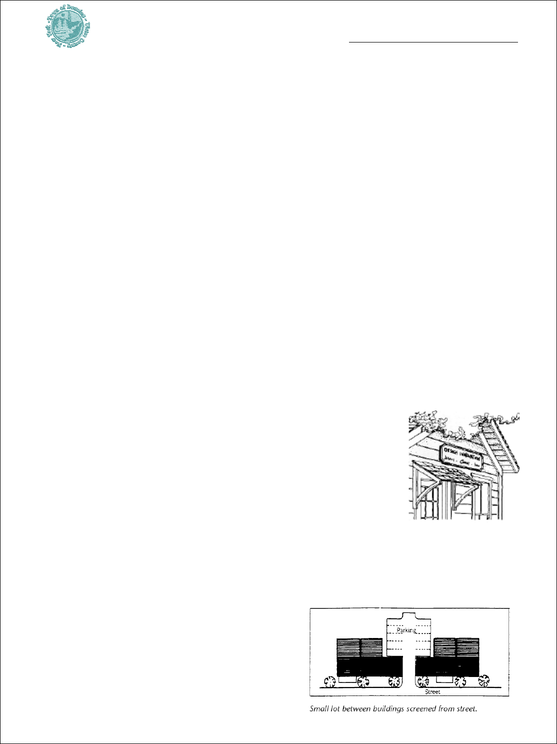
Town of Denning Comprehensive Plan
- 32 -
It is not the intent of this Comprehensive Plan to reduce the total number of acres designated
as Hamlet over the very long-term. In other words, there should be strong consideration in
the future of adding new Hamlet areas that are suitable and complementary of this form of
development, since the Town obviously needs the ability to provide housing on small (one
acre, minimum) lots for the needs of businesses, our children who need affordable housing,
and the need for a center of commerce and culture. Careful study and community dialogue
can identify areas that may be most suitable for future hamlet extensions. Study should
consider the regional trends and housing market conditions. This Comprehensive Plan
recognizes the need for future Hamlet acreage to replace what has been lost through New
York DEP conservation easements and impossibly steep slopes. In deference to the clear
desire at this point of the general population of Denning to refuse to consider future possible
Hamlet nodes, this Comprehensive Plan merely points out the very real future need to deal
with this question, and leaves this necessity to future Comprehensive Plans.
A few additional strategy recommendations follow that apply to specific locations.
3.6.1 Sundown & Peekamoose -- Reconfigure the Hamlet zone based on geographic
conditions. Provide five acre ‘Rural Residential zoning on the highly constrained lands around
sundown. Focus on reinforcing the historical and existing development patterns and removing
these lands encumbered by high levels of constraints. This will help promote community
character by emphasizing activity nodes in the valley which are most suitable for future
residential development. Town officials should also be aware that residents here do seek more
flexible ways to deal with solid waste disposal.
3.6.2 Claryville
3.6.2.1 Create a More Focused Hamlet Node – This will help
direct neighborhood growth within suitable areas. Transferring a part
of the existing Hamlet zoning district to the lower density Rural
Residential zone will promote open space and rural character.
Performed in conjunction with upgraded land use laws, it will provide
a basis to promote and encourage focused economic development and
infrastructure investment around Claryville.
3.6.2.2 Provide Basic Hamlet Design Guidelines/Illustrations to Explain Desired
Form & Land Use Practices – Hamlets are locations of significant public investment. It is
essential to guide new building so its layout
compliments community character. Formulating
basic design guidelines accompanied by
illustrations and examples will show stakeholders
how to achieve new development that is optimal.
Specifically, illustrations can show what is desired

Town of Denning Comprehensive Plan
- 33 -
for building setbacks, the layout of signs on sites, methods for landscaping, lighting,
stormwater management, driveway access and parking. Ultimately, these tools promote high-
quality sites. It can show how to fit new development within the existing settlement pattern
and through good quality design, cultivate support for other compatible economic
development.
Clearly, the numerous planning strategies that seek to enhance the tax base and provide jobs
depend on some new development in the designated hamlets. Public opinion favors steps to
direct growth or promote economic development that will be compatible with the protection
of very small town features that people value.
The incorporation of pictures and diagrams into the Town code will help make it easier to
use. In conjunction with developing design guidelines, it is also proposed to update the mix of
uses requiring a special use permit. Introducing performance
standards can ensure that the aspects of a use meet the minimum
objectives for building layout, appearance, massing, screening,
setback, height, noise and traffic management or site appearance.
Those uses that require a special use permit have to meet the
terms and conditions specified under the zoning code and as
required by the permit granting body, while site plan review will
help ensure that new development is sited and carried out so
that it does not detract from public health and safety.
Achieving some new development in the hamlets is one
component of enhancing the fiscal base of the Town. It is also
the mechanism through which there can be some expansion of
the basic mix of services available in the community. However,
in order to successfully guide new development to these centers,
good quality layouts need to be achieved in order to build
support for additional investment. Illustrative design guidelines
should help provide a framework within which to evaluate new
proposed development in the Hamlets.
3.6.3 Frost Valley & West Part of Denning
3.6.3.1 Promote Education on the History of Frost Valley --
While Denning is primarily
defined by its natural character, its history is remarkable. An important aspect of future
economic development centers on achieving growth that fits with and enhances the quality of
existing places so as to reinforce community character and maintain an attraction for visitors.
Part of a process of identifying how to achieve new development that is sensitive to existing
resources is defining and describing what is unique and important in the community. Since
Denning’s recreation economy centers on the 40,000 annual visitors to the Frost YMCA and
people traveling up Frost Valley Road on their way to the Catskill High Peaks, the visitor

Town of Denning Comprehensive Plan
- 34 -
experience could be enhanced if there were greater awareness and understanding of the
Valley’s history, particularly that as former great estate.
Frost Valley YMCA’s west valley campus has a remarkable building fabric and history.
German wool industrialist Julius Forstmann, who had a 2,200 acre estate on the site in
the late 1800s, was the person who introduced deer to the Catskills. Among potential historic
resources on-site are the ‘Castle’, the building used for visitor intake, remnants of the late
1800’s deer fence, other period camp buildings, and stone walls. Since the YMCA has an
educational mission and the organization is a major land owner, the large contiguous area it
controls in the West Valley combined with the YMCA’s institutional resources make the
campus a good candidate for defining and publicizing the history of the site.
An example of a planning success story in Denning was the effort surrounding the
preservation of Red Hill Fire Tower. The tower is on the National Register of Historic Places
and it is provided on-going stewardship by a local non-profit group. The tower is a defining
feature of the community. Likewise, the YMCA has a remarkable campus. And as the YMCA
defines its future development plans, information on the history of the site should be made
available and used to inform possible mitigation against the impacts of physical development
on the various resources on- or adjacent to the site. If the YMCA places its facilities on the
National Register, that could serve as a draw for more visitors.
Other portions of Frost Valley are also candidates for historic preservation planning. Similarly,
there are remarkable buildings in other parts of the community, including all along Denning
Road. The Town, however, would benefit most by incrementally developing its efforts at
promoting historic preservation. Recognizing that the community has a small population,
there likely would be limited volunteer resources. There are limited state funds available to
assist preservation planning. Small steps should be taken to explore the potential and desire
for additional preservation in-Town.
3.6.3.2 Consider a Very Small, Contained Hamlet in the Central Frost Valley – As
part of long-range
economic planning it may be beneficial to provide a very small Hamlet
zoning designation, constituting roughly 20 acres on the Frost Valley Road midway between
the bridge to Denning Road and the main Frost Valley YMCA campus. This location with
scenic surroundings has some generally flat areas and gentle slopes rising out of the floodplain
further east. This site may be suitable for carefully planned residences and service type uses. It
could be arranged with an integrated pattern of buildings and landscaping, compatible with
the existing building fabric. It could have open space, and be carried out with limited frontage
and controlled access/egress out onto the Frost Valley Road.
During public comment on the Preliminary Plan, there was divided opinion on additions to
the hamlets. As a result, the area in Frost Valley was defined as a ‘Potential Future Hamlet’.
This means the location may possibly
be suitable for neighborhood style development at some
point, although it is not proposed to change the zoning to Hamlet when the Comprehensive

Town of Denning Comprehensive Plan
- 35 -
Plan is approved. By identifying spots for new potential hamlets, the notion is to encourage
analysis regarding the impacts if these areas were added to the hamlet zone at an undefined
point. In other words, while the spot may potentially be suitable as a Hamlet addition in the
future, the topic requires more details. Products that could aid this deliberation are diagrams,
concept plans, discussion documents and analyses about the alternative types of growth that
may occur, how laws and public review would be structured, buildings and infrastructure
placement, appearance, screening and integration with the natural environment.
Visitors traversing County Route 47, conducting trips to the YMCA or the high peaks may
provide market support for small-scale bed and breakfasts, a restaurant and other limited retail
needs. A process to advance a potential hamlet would require supplemental analysis under
SEQRA. At this spot it would be critically important for any development to have a partial
grid street system for mobility within the site, while providing careful traffic controls at Frost
Valley Road. Finally, it must be clear that any future proposed zoning amendment considered
for this area should be of limited scope, preferably no larger than 25 acres, and in no case
encompassing more than 20% of the total designated hamlet zoning area within the Town.
This will help to ensure that any growth will be compatible with its rural and scenic charter.
3.6.4 Ladelton and Denning - Like item 3.6.3.2, it is recommended that places within
these areas may potentially be suitable for hamlets at some point in the future. However, these
notions, or concepts, are not recommended for action early-on. A main topic of dialogue
regarding the Plan has been the proposals for possibly encouraging some new hamlets. The
split of opinion is evident in the responses to Question #26. The fact that more than 1/3 of
respondents were either undecided (30%) or did not answer the question (5%) would seem to
indicate that people want more information, descriptions and details. Alternatively, they may
not feel that it is feasible for the public sector to manage new development so that it can be
balanced and integrated with the very small town, rural qualities they cherish. They may seek
more pictures, diagrams, concept plans, discussion documents and analyses about the types of
growth that may occur, how laws and public review process would be structured, where
buildings could be placed, their appearance, how these would be screened and integrated with
the natural environment, and how the excellent quality of the streams and adjacent forest
would be protected should this development be contemplated.

Town of Denning Comprehensive Plan
- 36 -
3.7 COMMUNITY BUILDING & PARTICIPATION
Denning’s small population, relative inaccessibility, and low density geography on the
County’s edge, combined with many seasonal residences and limited newspaper coverage, are
all aspects of the challenge of building community and fostering communication. Still, the
Town should take pride in how its affairs are publicized and made accessible to the interested
public at Town Hall and via the internet. Given the intent to forge a sustainable future based
on carefully planned and managed growth, the local public sector should benefit from even
greater efforts to foster broad outreach on policy development. Continuous efforts to keep
the public abreast of public affairs will ensure that everyone has the opportunity to know
about various initiatives and participate-in and shape the community’s future.
The process to develop the Comprehensive Plan has been inclusive and may serve as a model
for public outreach. The proposed Plan was available on the internet, as well as the Library
and High School. A more basic means of getting the word out on the planning process was
the distribution of flyers regarding upcoming public outreach meetings at the Town’s solid
waste facility. Encouraging feedback on the proposed plan through the Town’s web message
board is an innovative communication medium.
Assuming that a well informed and interested populace is critical to achieving various
proposals in the Plan, the Town Board should identify how to bolster the overall public
processes, including plan implementation, by continuing to proactively share information
crucial to decision-making. Providing enhanced public communications, such as routine
reports on events or issues within the Town, either in print or through the Town web page
can easily become stagnant or a low priority. Therefore, the Town Board and its assignees
should carefully monitor and evaluate the relative successes of various outreach initiatives.
What follows are recommendations for enhancing public information and outreach.
3.7.1 Promote Community & Communication Through an Event – Holding an
annual community-oriented event that fosters civic pride would help build local identity,
enhance communication and promote familiarity with issues. The monthly pancake breakfasts
at Claryville Fire Hall are a community-building event. As a means to promote knowledge of
public officials and interaction among residents, the Town Board could consider hosting a
community-wide gathering around July 4 or Labor Day each year. Geared towards celebrating
local heritage and civic pride, as well as promoting social interaction among residents, the
event could also publicize important topics in the public sector. A regional bank or other
institution may be asked to donate goods and services, with local non-profit groups assisting
in organizing and carrying out the event.
3.7.2 Continue Pushing Public Communications -- 50 years ago Denning’s hilly
topography influenced innovation when local entrepreneur, Fred Ahernts, ran a cable from
Wildcat Mountain to local homes, initiating an early form of cable television, and overcoming

Town of Denning Comprehensive Plan
- 37 -
an obstacle to receiving news. It should be possible to achieve easier access to information.
The limited budget of the Town means that Town Hall is open limited hours per week.
People’s activity patterns vary greatly – some persons have obligations during traditional
business hours, others may keep different hours than those of Town Hall. The Town Board,
working with Town Clerk, should develop protocols for electronic posting of public records.
The Town has already invested in much of the needed technology. What is required is thought
as to priorities. For example, since physical development could affect the community’s future,
formal procedures could be developed to require applicants for larger subdivision, site plan or
special permit applications to submit an electronic copy of permit applications. This would
allow the information to be posted on the web page for general viewing and possible
comment. Similarly, proposed budgets could be posted for review prior to action. Recent
changes in the New York State Environmental Quality Review Act already require that any
Environmental Impact Statement shall be posted on the internet. Therefore, actions to
promote enhanced access to information are likely to jibe with the public interest as well as
improve the accuracy of submissions and the ease of processing by municipal staff.
3.7.3 Bolster Emergency/ Hazard Plans & Communications – Natural disasters,
such as severe rain, snow or wind storms, could threaten or isolate parts of the Town for
significant periods and pose a public health concern. Detailed local emergency plans should
define and prepare for different types of emergencies and describe actions in the event these
arise. Clearly, the responses to past events, such as the rain storms and flooding in 2002 and
2005, were well coordinated between the County Emergency Management Agency, local
volunteer fire departments and the public sector, including the Highway Department. A
question remains how to enhance planning and preparation for various potential emergencies,
including how best to execute plans and achieve clear, consistent and thorough
communications during an incident.
As part of a system of enhanced public communications, it would benefit community
residents if the process to develop and publicize local and regional emergency response plans
is broad and inclusive. The Claryville Fire Company is actively involved with Ulster County in
developing its emergency response plan for the area covered by the Company. In Denning,
challenges include: coordinating responses across multiple jurisdictions since these are likely to
involve Sullivan and Ulster County officials, Neversink and Claryville Fire Companies and
determining approaches to effectively broadcast emergency plans and foster communications
with vulnerable populations during an event. There should be procedures developed for
communicating with elderly residents about how to prepare for and act in an emergency. As
the Town strives to enhance its telecommunications systems, particularly providing cellular
phone coverage and higher speed web access, phone and cable companies should be
encouraged to define what services they may be able to offer the community in order to
enhance emergency communications. The steps above should bolster the social networks,
help cultivate both the formal and informal safety network, and promote safe living situations
for elderly people and families.

Town of Denning Comprehensive Plan
- 38 -
4.0 ACTION PLAN: PROPOSED FIVE TO TEN YEAR
SCHEDULE FOR PLAN IMPLEMENTATION
Plan development is the first step in a longer process. The power of a plan rests in its
implementation. By involving the community in the development of this Plan, it is hoped that
its members will work together toward achieving the vision and goals outlined herein.
4.1 Organizing for Action
An important part of plan implementation is coordinating with regional elected officials and
public administrators outside of the community to gain programmatic support and financial
assistance. The Ulster County Department of Planning, in particular, would be a necessary
partner in implementing the Plan. Similarly, non-profit organizations and businesses should be
engaged in an attempt to build collaboration and partnerships that will effectively form
programs and steps that can advance community development – the Frost Valley YMCA and
the Catskill Watershed Corporation are key partners in that arena.
Although the Town is ultimately responsible for implementing the Plan, cooperation by
citizens, land owners, business owners, and others will help shape the future of Denning. The
Town should encourage community participation at all stages of the subsequent planning
process, including them as partners on certain projects and programs. In Tables 1 – 3, which
collectively form the overall Action Plan, specific steps to act on the Plan are listed and
prioritized. In each case responsibilities are assigned. Some actions have multiple steps to
achieve the strategy.
4.2 Implementation Matrices
The Plan provides guidance and recommendations to help maintain the desired community
character, address needs and opportunities. There are approximately 50 main actions that are
identified in the ‘Recommended Strategies’. Potential funding and technical assistance sources
are identified to help achieve each action. The Action Plan is intended as a practical guide for
implementing the Plan over roughly the next ten years. The following Tables (or matrices) are
meant to serve as a reference and a starting point for the effort ahead, and should be amended
and revised as a working tool throughout the next several years. In the following tables:
• Proposed Actions/ Strategy -- lists the actions necessary to achieve the Plan vision
and its goals (a ‘key’ is provided below identifying the acronyms and abbreviations used
in Table 1).
• Project Lead -- is the elected or appointed body that is suggested to take principal
responsibility for initiating a particular Plan strategy or action.

Town of Denning Comprehensive Plan
- 39 -
• Supporting Groups/ Agencies are the various entities identified that support the
project lead.
• Resources -- Possible sources of support, such as technical expertise or financial
assistance are also identified in most instances.
• Priority – presents suggestions about the actions that may be advanced earlier or later
within the specific subset contained in a particular table.
Basically, Table 1 provides actions that are recommended as the building block first steps or
higher priorities. The time frame for Table 1 is one to two years. Table 1 includes a suggested
public process to update the Town’s zoning consistent with the main zoning and land use
regulation upgrades recommended in the Plan. As this Plan is a program, or a guide, for the
long-range community development, there would be a unique public process, including
hearings, to consider various local code proposals and officially adopt these new laws or
regulations. Table 2 presents secondary objectives, including actions that build on the
precursor actions set up during the first two years. Table 3, likewise contains more
complicated objectives, as well as planning strategies that may have less solid support.

Town of Denning Comprehensive Plan
- 40 -
KEY: Acronyms & Abbreviations Used in the Action Plan Matrix: Tables 1 - 3
Ag & Markets = NYS Dept. of Agriculture & Markets
CCCD = Catskill Center for Conservation and Development
CCE = Cornell Cooperative Extension
Chambers = Local/regional Chambers of Commerce
CWC = Catskill Watershed Corporation
DEC = New York State Department of Environmental Conservation
DEP = New York City Department of Environmental Protection
Foundation = non-profits organized to aid research/ education on set topics
FVYMCA = Frost Valley YMCA
GOSC = Governors Office for Small Cities (NYS)
HRVG = Hudson River Valley Greenway
LTAP = Local Technical Assistance Program grant of CWC
NA = Not Applicable
NFIP = National Flood Insurance Program
NY DOS = New York Department of State
WQPIG = Water Quality Planning Implementation grant awarded in 2006
NYAG = New York Attorney General's Office
NYC DEP = New York City Department of Environmental Protection
NYDEC = New York State Department of Environmental Conservation
NYOSC = New York State Office of the State Comptroller
NYOFT = New York State Office for Technology (under the Executive branch)
NYS = New York State
NY SEMO = New York State Emergency Management Office
NYS EPA = New York State Environmental Protection Act Parks Program grants
NYSERDA = New York State Energy Research Development Authority
NYS GML = New York State General Municipal Law
NYS Qualities Community = New York State Quality Communities Grant program
NYS TL = New York State Town Law
OPRHP = Office of Parks Recreation Historic Preservation (NYS)
RCAP = RCAP Solutions (a regional non-profit, formerly RHI, Inc.)
RUPCO = Rural Ulster Preservation Company (regional private, non-profit housing organization)
Sherriff = Office of the Sheriff Ulster County
SC = Sullivan County
School Dist. = Tri-Valley Central School District
TA = Technical Assistance
ToN = Town of Neversink
Town Bd. = Denning Town Board
UC = Ulster County
UCDC = Ulster County Development Corp & Industrial Development Authority
UCEM = Ulster County Emergency Communications / Emergency Management Dept.
UCEMC = Ulster County Environmental Management Council
UC Health = UC Health Dept.
UC Planning = UC Planning Board &/or UC Planning Dept.
USDA = U.S. Department of Agriculture/ Rural Development Agency programs
Utilities = local telephone and electric utilities
VFDs = Volunteer Fire Departments (Including Claryville Fire District & Neversink Fire Co.)
WAC = Watershed Agricultural Council

Town of Denning Comprehensive Plan
- 41 -
Table 1 -- Action Plan Matrix: Recommended Early Stage Actions
Item Proposed Action / Strategy
Project
Lead
Supporting Groups/Agencies
Resources
(
Funding or Technical Assistance)
Priority
-
Join Hudson River Valley Greenway
Town Bd.
NA -- ACTION IMPLEMENTED
-
-
Promote Reuse of Blue Hill Lodge
Town Bd. Planning Bd.; FVYMCA
NA -- ACTION ACHIEVED
-
3.1.4
Define density based on the incidence of constraints
Planning Bd. Town Bd.; County Planning NYSDOS WQPIG
1
3.4.4
Modify Logging Law
Town Bd.
Highway Superintendent; Planning Bd.;
Building Inspector; Town Clerk WAC and CCE technical assistance
1
3.5.1
Consider a Right to Forest & Farm Law
Town Bd. TA requests: WAC; CCE
1
3.7.3
Bolster Emergency Management Plans & Hazard
Communications
VFDs
Town Bd.; UCEM; SC; ToN; Phone &
Cable Cos; Sherriff; NYS; Utilities
NYSEMO Local Emergency
Operations Planning Prog.; Pre-
Disaster Mitigation Prog.; NY OFT:
Statewide Wireless Network
1
3.1.1
ID & Define Key Environ. Resources – Catalog special
features, natural resources to promote protection
CAC
Town Bd.; UCEMC; Hudsonia; FVYMCA;
County Planning; CCCD;
NYS DEC Hudson River Estuary
grant; UCEMC; County Planning; an
interested Foundation
1
3.1.1
Consider establishing a local Conservation Advisory
Council (GML 239-x)
Town Bd. UCEMC; FVYMCA; Planning Bd.
UCEMC; Hudsonia; Hudson River
Estuary Grant; possibly Foundation
financial assistance
1
3.1.2
Institute Viewshed Overlay Zoning
Planning Bd. Town Bd. NYSDOS WQPIG
2
3.3.1
Establish Low Density Zoning
Planning Bd.
Town Bd.; UC Planning Board; possible
also UCEMC if need supporting data NYDOS WQPIG
2
3.3.2
Promote Land Use Coordination on Estates
Town Bd. FVYMCA; Planning Bd FVYMCA
2
3.3.3
Clarify/Refine Use Sched., Standards, Site Plan Process
Planning Bd. Town Bd.; UC Planning Bd. NYDOS WQPIG
2
3.3.4
Clarify the Subdivision Plan Review Process & Standards
Planning Bd. Town Bd.; UCPB; Highway Superintendent NYDOS WQPIG
2
3.1.3
Achieve Open Space Design (AKA conservation design)
Planning Bd.
Town Bd.; Co. Planning; Highway Super;
CAC; CCCD; (also plan with non-profits,
Open Space Instit., Nature Conservancy).
NYDOS WQPIG
2
3.4.2
Seek external funds/ tech assistance for detailed study of
road performance
Highway
Super.
Town Bd.; Planning Bd.; UC DPW; UC
Planning; DOT
NY Quality Communities Grant;
Maybe NYDOT Regional Office
2
3.4.3
Adopt Driveway & Common Driveway Standards
Highway
Super
Town Bd.; Planning Bd.; UC DPW; UC
Planning
NYDOS WQPIG
2
3.3.4
Clarify zoning & subdivision regs. Re minimum frontage
requirements and road improvement standards
Planning Bd.
Town Bd.; Highway Super.; VFD Chief; UC
Planning NYDOS WQPIG
2
3.4.5
Clarify Road Construction Policies/Standards
Planning Bd.
Town Bd.; Highway Super.; VFDs Chief;
UC Planning
NYDOS WQPIG
2
3.5.4
Promote high performance public building and
incentivize these buildings in the private sector
Planning Bd.
Town Bd.; School Bd.; FVYMCA;
NYSERDA
NYDOS WQPIG; NYSERDA;
USDOE
2
3.6.3
Reconfigure (Reduce) the Hamlet Zones and Provide
Basic Hamlet Design Guidelines & Illustrations
Planning Bd. Town Bd. NYDOS WQPIG
2
3.5.9
Adopt Land Use Management Standards for windmills,
photovoltaic, small hydro, small cogeneration
Planning Bd. Town Board; NYSERDA NYDOS WQPIG
2

Town of Denning Comprehensive Plan
- 42 -
Table 2 -- Action Plan Matrix: Recommended Mid-Term Actions
Item Proposed Action / Strategy
Project
Lead Supporting Groups/Agencies
Resources
(Funding or Technical Assistance)
Priority
3.5.11
Promote Predicable/Reasonable Revenue Streams
from Non-Profits & State Lands
Town Bd. NYAG; NYOSC; Planning Bd.
NY DOS WQPIG; CWC LTAP; Quality
Communities; GOSC Strategic Planning grant
3
3.2.2
Formulate a Hazard Mitigation Plan
Town Bd.
Planning Bd; VFDs; UCEM; SC; Sheriff;
NY SEMO
NY Hazard Mitigation Grant Program; Flood
Mitigation Assistance Program (FMA) grants
3
3.2.1
Provide outreach & information on the ways to
promote community housing
Town Bd. Planning Board; UC Planning County Planning
3
3.4.1
Develop a Capital Improvement Plan
Town Bd.
Highway Superintendent; Planning Bd.;
VFD, School Super.; School Bd., Other
Towns in the School District; Library
GOSC Strategic Planning Grant
TA, like: NYDOS; Office of State
Comptroller, Div. of Local Gov. Services
3
3.5.14
Inventory the Business & Worker Base
Town Bd. UCDC; CCE; Ag & Markets
GOSC Strategic Planning grants. Request
technical assistance, such as from Marist
College Bureau of Economic Research
3
3.5.2
Evaluate agricultural opportunities in Denning,
feasibility of small-scale agriculture
CAC
Town Bd.; FVYMCA; UC Coop.
Extension; UC Planning
Grow New York programs (See NYS Dept. of
Agriculture & Markets)
3
3.5.5
Promote Better Phone Service -- outreach to utilities
for telecomm & cable service, high speed internet
Town Bd.
FVYMCA; Empire State Development;
Utilities; Regional Chambers of Commerce
USDA; NYSERDA; Monitor NYS 'Universal
Broadband Initiative
3
3.5.8
Partner with FVYMCA in Economic Development
Programming
Town Bd. FVYMCA
GOSC Strategic Planning grants; USDA
programs.
3
3.5.9
Explore Distributed Generation Potential - examine
feasibility, financing, provide public outreach and
plan for compatible installations
Town Bd. NYSERDA
NYSERDA TA, grants, loans; USDA;
foundations; carbon offset programs
investments
3
3.5.10
Consider an 'Official Map' developed sequentially
over 3 - 7 yrs
Town Bd.
Highway Superintendent; Planning Bd.;
UC Highways and Bridges Dept.
NYS EPA grant; GOSC Strategic Planning
grants; LTAP; Quality Communities; US Land
& Water Conservation Fund.
3
3.7.2
Enhance Public Communications – Develop
protocols for electronic posting of public records
Town Bd.
Town Clerk, Planning Bd.; Neversink
Library; possibly also School District
NYS Archives Grant
3
3.5.2
Encourage Community Supported
Agriculture/organize a cooperative
Interested
Residents FVYMCA; CAC; WAC
CWC; Foundations; CCE; CCCD; NYSA&M,
UC Purchase of Development Rights; WAC
4
3.6.3
Promote Education on the History of Frost Valley
FVYMCA
Planning Bd.; OPHRP; Red Hill Fire
Tower Group; CCCD
OPRHP technical assistance; Foundation
(financial assistance)
4
3.2.1
Monitor local and regional housing market
conditions
Planning
Bd.
County Planning; Town Board; Building
Inspector GOSC Strategic Planning grant
4
3.1.5
Institute floodplain development zoning
Building
Inspector
Planning Bd; Town Bd.; NYC DEP, UC
Planning; UCEMC NYC DEP, NFIP; LTAP
4
3.7.1
Promote Community/Communication with Event
Town Bd.
Regional Bank; local community orgs or
non-profits NA
4
3.2.1
Aid the repair/rehabilitation of housing for moderate
income homeowners, older persons, renters
Town Bd.
County Planning; Planning Board; Building
Inspector; NYS DHCR; RUPCO; RCAP;
local contractors
DHCR Housing Grants and loans; USDA
grants and loans; local banks
4

Town of Denning Comprehensive Plan
- 43 -
Table 3 -- Action Plan Matrix: Recommendations For Later Stage Actions
Item Proposed Action / Strategy
Project
Lead
Supporting Groups/Agencies
Resources
(Funding or Technical Assistance)
Priority
3.2.2.
Apply for hazard mitigation grants
Highway
Superint. Town Board; VFDs; UCEM; NYSEMO
NYSEMO Flood Mitigation Assistance
Program (Flood Mitigation Assistance,
Repetitive Flood Claims, Severe Repetitive
Loss); Pre-Disaster Mitigation Program
5
3.5.7
Publicize the FVYMCA's Research and Resource
Protection Programs
Town Bd. FVYMCA; CAC (if established) NA
5
3.5.13
Aid establishment of a local consumer 'buying club
Interested
Residents Town Bd. NA
5
3.4.2
Institute pavement management system/ consider
using software, local purchase or with adjacent
towns, for a pavement management program
Highway
Superint.
Town Bd.; Planning Bd.; UC DPW; UC
Planning; DOT; ToN
Quality Communities grant; Water Quality
Improvement Project grant; NYS Clean
Water/Clean Air Bond Act (nonpoint)
5
3.4.2
Choose between dirt roads or pavement on roads
Town Bd.
Planning Bd.; Highway Super.; UC DPW;
UC Planning
5
3.2.1
Ensure Suitable Options for Future Housing
Planning
Bd. Town Bd.; County Planning; FVYMCA
DHCR; LTAP; Quality Communities; GOSC
Strategic Planning grant
5
3.5.6
Explore feasibility, methods of organizing a
Furniture Crafting Guild/Cooperative
Town Bd. CWC; UCDA
CWC resources: Natural Resource-Based
Industry Grant; Regional Economic
Development Initiative; Job Creation &
Retention Grant Prog. Greenway Grant prog;
GOSC Strategic Planning grant
5
3.5.11
Advocate for State Property Tax Reform - draft &
pass a resolution in support of this objective
Town Bd.
Other Elected Officials, adjacent
municipalities (esp. the Town of
Rochester)
5
3.2.1
Consider Hamlet additions: Denning, Ladleton and a
small, contained Hamlet in Central Frost Valley
Town Bd. Planning Bd.; UC Planning LTAP; Quality Communities grant
5
3.5.3
Explore a small passive park, multi-purpose ballfield
in Town; possibly small playground in Claryville
Town Bd. OPRHP: Environmental Protection Fund
5
3.1.6
Develop a Local Stream Management Plan
Planning
Bd.
NYC DEP, Highway Superintendent;
Planning Bd.; DEC; UCEMC
NYC DEP, Water Quality Improvement Proj.
Grants, NYS Clean Water/ Clean Air Bond
Act (resources for nonpoint source abatement)
6
3.1.8
Provide long-range monitoring of lot-based septic &
water systems
Building
Inspector
NYC DEP; UC Health Dep.; Town Bd.;
Planning Bd.
NYCDEP
6
3.5.3
Restore Denning participation Neversink Recreation
Comm. to promote healthy lifestyles for children
Town Bd. ToN; School Dist.
6
3.5.7
Water Bottling Co./Cooperative - encourage small-
scale industry based on a sustainable yield;
possibly with profits directed to tax relief
Town Bd. UCDA; CWC
Greenway Grant; USDA; GOSC Strategic
Planning grants
6

Town of Denning Comprehensive Plan
- 44 -
In order to guide implementation of Denning’s Comprehensive Plan, it is suggested that a
Comprehensive Plan Implementation Committee be established to oversee progress following up
on the recommendations within the Plan. In an era of many issues and competing demands, it is
important for the various actors in the Town administration to work together on a wide range of
issues to communicate, determine shared objectives, and identify how different actions can be
coordinated to advance the goals of the Plan.
4.3 Keep the Dust Off This Plan
A Plan implementation process should involve periodic reviews and updates, as well as the
identification of alternatives if any recommendations prove to be unattainable. Key players include
the Town Supervisor and the Town Board, most Town departments, various Boards,
Commissions and Committees, the interested public, land owners, non-profits, and partners at the
regional level. Plan realization will require effort and cooperation among many parties -- lead
implementation entities are encouraged to identify broad sources of support. This Plan should
serve as a reference and as a starting point for the planning effort ahead, and it should be amended
and revised as a working tool throughout the next several years.
